The History of Agriculture 농업의 역사
1. Hunting and Gathering (Pre-Agricultural Era) 수렵·채집 (농업 이전 시대)
Characteristics: Humans lived in small, nomadic bands (typically fewer than 50 people), constantly migrating to follow seasonal game and plant availability.
특징: 인간은 작고 유목적인(nomadic) 무리(band; 보통 50명 미만)로 살았고, 계절에 따라 달라지는 사냥감과 식물을 따라 끊임없이 이동했다.
Environmental Dependency: Population growth was strictly limited by natural carrying capacity, as food could not be stored in large surpluses.
환경 의존성: 식량을 큰 잉여로 저장할 수 없었기 때문에, 인구 증가는 자연의 수용력(carrying capacity)에 의해 엄격히 제한되었다.
2. Agricultural Hearths (Carl Sauer's Theory) 농업 기원지(hearth) — 칼 사워의 이론
An agricultural hearth is an origin center where the domestication of plants and animals first independently occurred.
농업 기원지(agricultural hearth)는 식물과 동물의 가축화·작물화(domestication)가 처음으로 독립적으로 일어난 기원 중심지이다.
The Bountiful Hypothesis: Geographer Carl Sauer argued that agriculture did not begin out of desperation or starvation. Instead, it started in bountiful environments—areas rich in natural resources where hunter-gatherers had the leisure time and security to experiment with plant breeding.
풍요 가설(Bountiful Hypothesis): 지리학자 칼 사워(Carl Sauer)는 농업이 절박함이나 굶주림에서 시작된 것이 아니라고 주장했다. 오히려 농업은 풍요로운 환경, 즉 천연자원이 풍부해서 수렵채집인(hunter-gatherers)이 식물 육종을 시험해 볼 여가 시간과 안정성을 가졌던 곳에서 시작되었다.
Exam tip: Sauer's bountiful hypothesis = agriculture began in rich environments with leisure and security, not from desperation or starvation. A choice saying "agriculture began because of starvation" is the trap.
시험 팁: 사워의 풍요 가설 = 농업은 여가와 안정성이 있는 풍요로운 환경에서 시작. 절박함·굶주림 때문에 시작되었다는 선지는 함정이다.
3. The First Agricultural Revolution 제1차 농업혁명
The transition from hunting and gathering to farming is known as the First Agricultural Revolution (Neolithic Revolution), which occurred right after the end of the last Ice Age (around 10,000 BCE).
수렵·채집에서 농경으로의 전환을 제1차 농업혁명(신석기 혁명, Neolithic Revolution)이라 하며, 마지막 빙하기가 끝난 직후(기원전 약 10,000년경)에 일어났다.
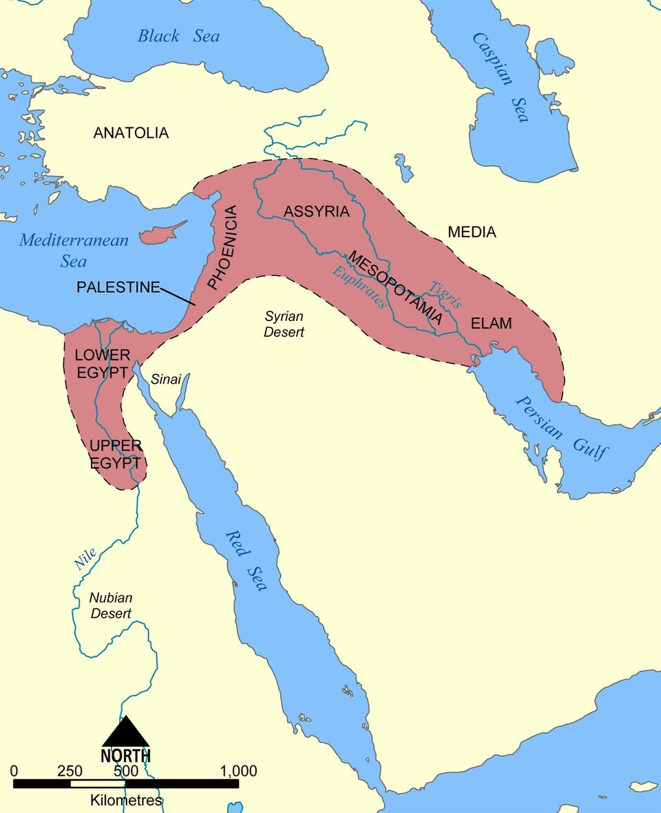
The Fertile Crescent: Located in Southwest Asia (modern-day Iraq, Syria, Jordan, Israel, Lebanon, and Egypt), this was the most significant agricultural hearth.
비옥한 초승달 지대(Fertile Crescent): 남서아시아(오늘날의 이라크, 시리아, 요르단, 이스라엘, 레바논, 이집트)에 위치하며, 가장 중요한 농업 기원지였다.
Key Innovations: It served as the primary hearth for major seed crops—specifically wheat and barley.
핵심 혁신: 주요 종자 작물, 특히 밀(wheat)과 보리(barley)의 주된 기원지 역할을 했다.
Impact: The shift enabled a sedentary lifestyle (settled farming), creating permanent settlements, food surpluses, population expansion, and eventually the world's first urban civilizations (Mesopotamia).
영향: 이 전환은 정착 생활(sedentary lifestyle; 정주 농경)을 가능하게 하여 영구 정착지, 식량 잉여, 인구 팽창, 그리고 마침내 세계 최초의 도시 문명(메소포타미아)을 낳았다.
⚠ Note: The slide's list of Fertile Crescent countries includes Egypt, and the map (F01) shows Lower/Upper Egypt. Learn the list as written on the slide.
참고: 슬라이드의 비옥한 초승달 지대 국가 목록에는 이집트가 포함되며, 지도(F01)에도 Lower/Upper Egypt가 표시된다. 슬라이드에 적힌 대로 외운다.
Founder crops of the Fertile Crescent: grains (emmer wheat, einkorn wheat, barley) and flax.
비옥한 초승달 지대의 창시 작물(founder crops): 곡물(에머 밀·외알 밀·보리)과 아마(flax).
4. Domestication & Animal Husbandry 작물·가축 길들이기와 가축 사육
Plant Domestication: The deliberate selection and breeding of wild plants for desirable traits (e.g., larger seeds, non-shattering stalks).
식물 작물화(Plant Domestication): 바람직한 형질(예: 더 큰 씨앗, 쉽게 터지지 않는 줄기)을 위해 야생 식물을 의도적으로 선택하고 육종하는 것.
Animal Domestication & Husbandry: The Fertile Crescent was also the primary hearth for domesticating major herd animals: cattle, sheep, goats, and pigs.
동물 가축화와 사육(Animal Husbandry): 비옥한 초승달 지대는 주요 무리 동물인 소, 양, 염소, 돼지를 가축화한 주된 기원지이기도 했다.
Animal Husbandry (the science of breeding and caring for farm animals) integrated livestock with crop farming.
가축 사육(Animal Husbandry)(농장 동물을 번식시키고 돌보는 기술)은 가축을 작물 재배와 통합시켰다.
Animals provided meat, milk, and hides, but crucially supplied draft power for plowing and manure for fertilizing fields, drastically boosting farm output.
동물은 고기, 젖, 가죽을 제공했을 뿐 아니라, 결정적으로 쟁기질을 위한 견인력(draft power)과 밭을 비옥하게 하는 거름(manure)을 공급하여 농업 생산량을 크게 높였다.
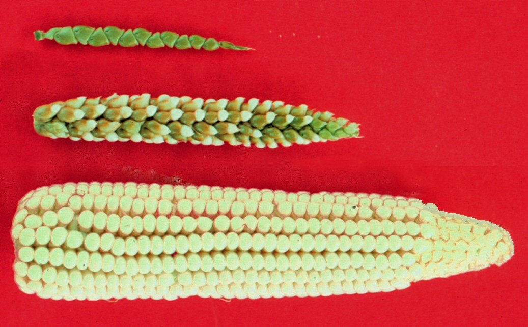
Slide title: "Crop Domestication" (photo slide).
슬라이드 제목: "작물화(Crop Domestication)" (사진 슬라이드).
Summary table: from hunting-gathering to farming 요약표: 수렵채집에서 농업으로
| Stage 단계 | Way of life 생활 방식 | Food / population 식량·인구 | Key point 핵심 |
|---|---|---|---|
| Hunting & gathering 수렵·채집 | Small nomadic bands (<50 people) 작은 유목 무리(50명 미만) | No large surplus; limited by carrying capacity 큰 잉여 없음; 수용력에 제한 | Follow seasonal game and plants 계절 사냥감·식물을 따라 이동 |
| Agricultural hearth (Sauer) 농업 기원지(사워) | Experimenting with plant breeding in bountiful areas 풍요로운 곳에서 식물 육종 시험 | Leisure time and security 여가와 안정성 | Not from starvation 굶주림 때문이 아님 |
| First Agricultural Revolution 제1차 농업혁명 | Sedentary, settled farming (~10,000 BCE, after last Ice Age) 정착 농경(기원전 약 10,000년, 마지막 빙하기 직후) | Surpluses, population expansion 잉여, 인구 팽창 | Fertile Crescent: wheat, barley; cattle, sheep, goats, pigs; first urban civilizations (Mesopotamia) 비옥한 초승달 지대: 밀·보리; 소·양·염소·돼지; 최초 도시 문명(메소포타미아) |
Exam tip: Plant domestication = selecting/breeding wild plants for traits; animal husbandry = breeding and caring for farm animals (and it supplied draft power and manure). Do not swap the two.
시험 팁: 식물 작물화 = 야생 식물을 형질 위해 선택·육종; 가축 사육 = 농장 동물의 번식·돌봄(견인력과 거름 제공). 둘을 바꿔 쓰지 말 것.
Agricultural Revolutions & Practices 농업혁명과 농업 방식
1. Agricultural Revolutions 농업혁명
First Agricultural Revolution (Neolithic Revolution): Transition from hunting and gathering to farming; origin of hearths (e.g., Fertile Crescent) through plant and animal domestication.
제1차 농업혁명(신석기 혁명): 수렵·채집에서 농경으로의 전환; 식물과 동물의 가축화·작물화를 통한 기원지(hearth)(예: 비옥한 초승달 지대)의 출현.
Second Agricultural Revolution: Coincided with the Industrial Revolution; introduced mechanization (tractors), crop rotation, and enclosures, leading to higher yields and urban migration.
제2차 농업혁명: 산업혁명(Industrial Revolution)과 같은 시기에 일어났으며, 기계화(트랙터), 윤작(crop rotation), 인클로저(enclosures)를 도입하여 수확량 증가와 도시로의 이주를 낳았다.
Third Agricultural Revolution (Green Revolution): 1950s–1960s introduction of High-Yield Variety (HYV) seeds, synthetic fertilizers, pesticides, and modern irrigation (notably led by Norman Borlaug).
제3차 농업혁명(녹색혁명, Green Revolution): 1950~1960년대에 고수확 품종(High-Yield Variety, HYV) 종자, 합성 비료, 살충제, 현대식 관개가 도입됨(특히 노먼 볼로그(Norman Borlaug)가 주도).
Impacts: Drastically increased food production in LDCs (especially Asia/Latin America), but caused environmental issues (water depletion, soil degradation) and socioeconomic inequality (small farmers priced out).
영향: 개발도상국(LDCs; 특히 아시아·라틴아메리카)의 식량 생산을 크게 늘렸지만, 환경 문제(물 고갈, 토양 악화)와 사회경제적 불평등(소농이 밀려남)을 초래했다.
⚠ Source inconsistency: this slide (U5 p12) dates the Green Revolution to the 1950s–1960s, while U5 p60 says 1940s to the 1970s/80s. Do not memorize the dates as a single fact; focus on HYV seeds, fertilizers, pesticides, irrigation, and Borlaug.
자료 불일치: 이 슬라이드(U5 p12)는 녹색혁명을 1950~1960년대로, U5 p60은 1940년대~1970/80년대로 적고 있다. 연대를 하나의 사실로 외우지 말고 HYV 종자·비료·살충제·관개·볼로그에 집중한다.
| Revolution 혁명 | Period 시기 | Key change 핵심 변화 | Impact 영향 |
|---|---|---|---|
| First (Neolithic) 제1차(신석기) | After last Ice Age (~10,000 BCE) / 마지막 빙하기 직후(기원전 약 10,000년) | Hunting-gathering to farming; plant and animal domestication; hearths 수렵채집→농경; 작물·가축화; 기원지 | Settled life, surpluses, population growth, first urban civilizations 정착, 잉여, 인구 증가, 최초 도시 문명 |
| Second 제2차 | Coincided with the Industrial Revolution 산업혁명과 동시대 | Mechanization (tractors), crop rotation, enclosures 기계화(트랙터), 윤작, 인클로저 | Higher yields and urban migration 수확량 증가, 도시로의 이주 |
| Third (Green Revolution) 제3차(녹색혁명) | 1950s–1960s (U5 p12; see warning) 1950~60년대(U5 p12; 위 경고 참조) | HYV seeds, synthetic fertilizers, pesticides, modern irrigation (Borlaug) HYV 종자, 합성 비료, 살충제, 현대식 관개(볼로그) | More food in LDCs (Asia/Latin America); water depletion, soil degradation, small farmers priced out LDCs 식량 증가; 물 고갈·토양 악화·소농 밀려남 |
Exam tip: Match revolution to feature. Tractors, crop rotation, enclosures = Second (with the Industrial Revolution, caused urban migration). HYV seeds, fertilizers, pesticides, irrigation = Third. Domestication = First.
시험 팁: 혁명과 특징을 짝짓기. 트랙터·윤작·인클로저 = 제2차(산업혁명과 동시, 도시 이주). HYV 종자·비료·살충제·관개 = 제3차. 가축화·작물화 = 제1차.
2. Agricultural Practices: Intensive vs. Extensive 농업 방식: 집약 대 조방
Intensive Agriculture: High labor/capital inputs per unit of land; usually near markets or on expensive land. Key examples: Market Gardening, Dairying, Mixed Crop/Livestock, Wet Rice.
집약 농업(Intensive Agriculture): 단위 면적당 노동·자본 투입이 많음; 보통 시장 근처나 비싼 땅에 위치. 주요 예: 상업적 원예(시장 원예, market gardening), 낙농(dairying), 혼합 작물·가축 농업, 벼농사(wet rice).
Extensive Agriculture: Low labor/capital inputs relative to vast land area; located on cheaper land. Key examples: Shifting Cultivation (Slash-and-Burn), Nomadic Herding, Livestock Ranching.
조방 농업(Extensive Agriculture): 넓은 땅에 비해 노동·자본 투입이 적음; 더 싼 땅에 위치. 주요 예: 이동 경작(화전; Slash-and-Burn), 유목(Nomadic Herding), 기업적 목축(Livestock Ranching).
| Intensive 집약 | Extensive 조방 | |
|---|---|---|
| Inputs per unit of land 단위 면적당 투입 | High labor/capital 노동·자본 많음 | Low labor/capital relative to vast land 넓은 땅에 비해 적음 |
| Location 입지 | Near markets or on expensive land 시장 근처·비싼 땅 | Cheaper land 더 싼 땅 |
| Examples 예 | Market Gardening, Dairying, Mixed Crop/Livestock, Wet Rice 상업적 원예(시장 원예), 낙농, 혼합 작물·가축, 벼농사 | Shifting Cultivation, Nomadic Herding, Livestock Ranching 이동 경작, 유목, 기업적 목축 |
Exam tip: "Intensive" and "extensive" describe inputs per unit of land, not whether the farm is subsistence or commercial. Wet rice (intensive) and nomadic herding (extensive) are both subsistence on slide p14; dairying (intensive) and ranching (extensive) are commercial.
시험 팁: 집약/조방은 단위 면적당 투입 기준이며 자급/상업과는 별개 축이다. 벼농사(집약)와 유목(조방)은 모두 자급농업(p14), 낙농(집약)과 방목 목축(조방)은 상업농업이다.
Subsistence Agricultural Economies 자급적 농업 경제
1. Subsistence agriculture overview 자급농업 개관
Target Region / Context: Primarily in Less Developed Countries (LDCs).
대상 지역/맥락: 주로 개발도상국(Less Developed Countries, LDCs).
Core Concept: Food production designed primarily for direct consumption and survival of the farmer's family.
핵심 개념: 농민 가족의 직접 소비와 생존을 주된 목적으로 하는 식량 생산.
Key Characteristics — Low Capital, High Labor: Minimal mechanization or technology; heavily reliant on human and animal labor.
주요 특징 — 낮은 자본, 높은 노동: 기계화·기술이 거의 없고, 사람과 동물의 노동에 크게 의존한다.
Small Scale: Small landholdings with little to no marketable food surplus.
소규모: 토지 보유가 작고, 시장에 내다 팔 식량 잉여가 거의 또는 전혀 없다.
Primary Types: Extensive Subsistence: Shifting Cultivation (Slash-and-burn), Nomadic Herding. Intensive Subsistence: Wet Rice Dominant farming (e.g., terraced rice fields).
주요 유형: 조방적 자급농업(Extensive Subsistence): 이동 경작(화전), 유목(Nomadic Herding). 집약적 자급농업(Intensive Subsistence): 벼농사 우세형(Wet Rice Dominant)(예: 계단식 논).
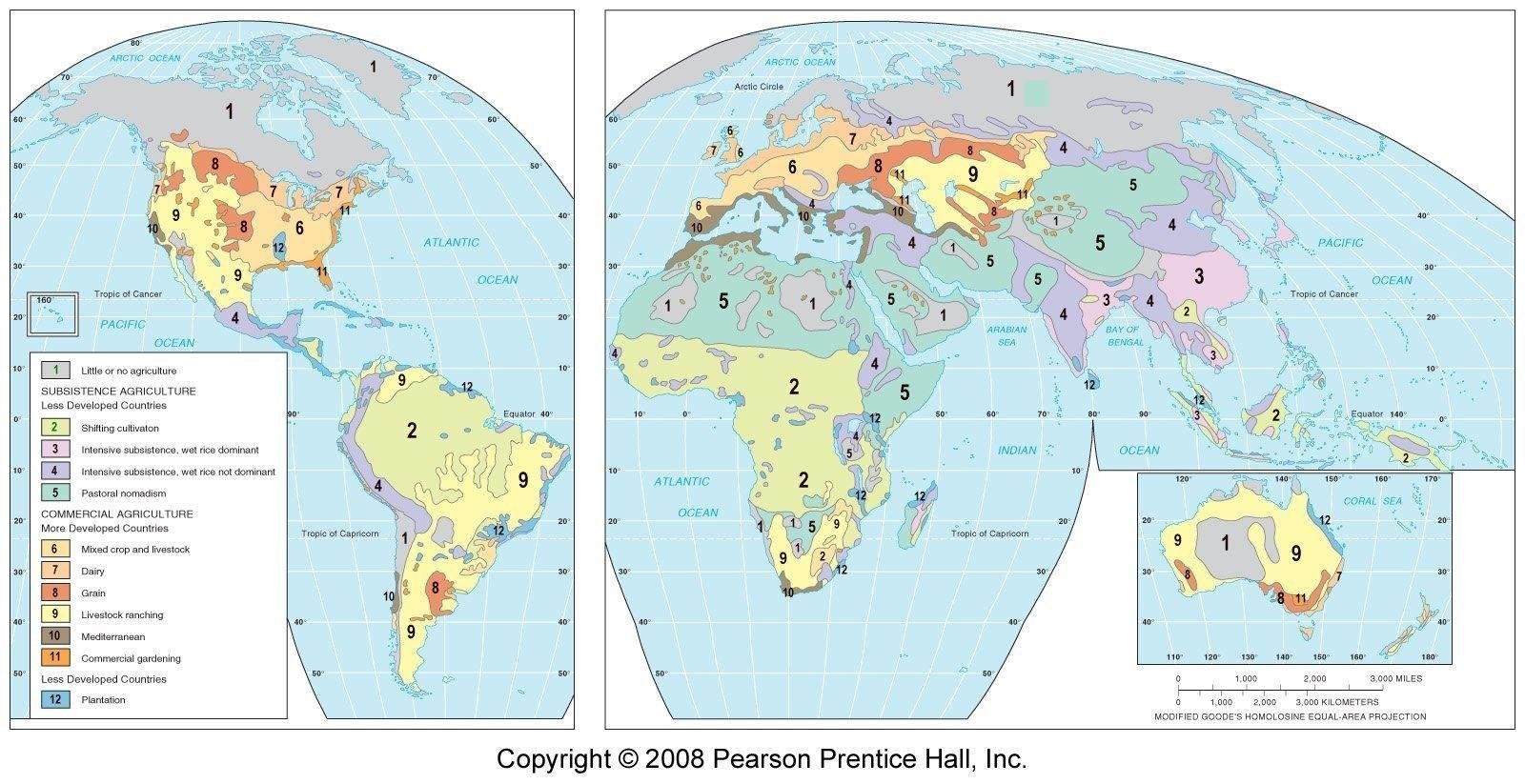
Map of subsistence / commercial farming 자급·상업 농업 지도
The slide shows a map of subsistence and commercial farming. Use the legend numbers 1–12 below exactly as printed on the map (F03).
이 슬라이드는 자급·상업 농업 지도를 보여준다. 아래 범례 번호 1~12는 지도(F03)에 인쇄된 그대로 쓴다.
| No. 번호 | Region (legend) 지역(범례) | Group 구분 |
|---|---|---|
| 1 | Little or no agriculture 농업이 거의 없음/없음 | – |
| 2 | Shifting cultivation 이동 경작 | Subsistence agriculture (Less Developed Countries) 자급 농업(개발도상국) |
| 3 | Intensive subsistence, wet rice dominant 집약적 자급, 벼농사 우세 | |
| 4 | Intensive subsistence, wet rice not dominant 집약적 자급, 벼농사 비우세 | |
| 5 | Pastoral nomadism 유목(목축 유목) | |
| 6 | Mixed crop and livestock 혼합 작물·가축 | Commercial agriculture (More Developed Countries) 상업 농업(선진국) |
| 7 | Dairy 낙농 | |
| 8 | Grain 곡물 | |
| 9 | Livestock ranching 기업적 목축 | |
| 10 | Mediterranean 지중해성 | |
| 11 | Commercial gardening 상업적 원예(시장 채소) | |
| 12 | Plantation 플랜테이션 | Less Developed Countries 개발도상국 |
⚠ Note: the map legend has 12 items, while a later slide summarizes "11" regions (5 in developing countries + 6 in developed countries). For map questions use the printed legend numbers; do not rely on the count "11".
참고: 지도 범례는 12개 항목이지만, 뒤쪽 슬라이드는 "11개"(개도국 5 + 선진국 6)로 요약한다. 지도 문제는 인쇄된 범례 번호를 쓰고, "11개"라는 숫자에 의존하지 않는다.
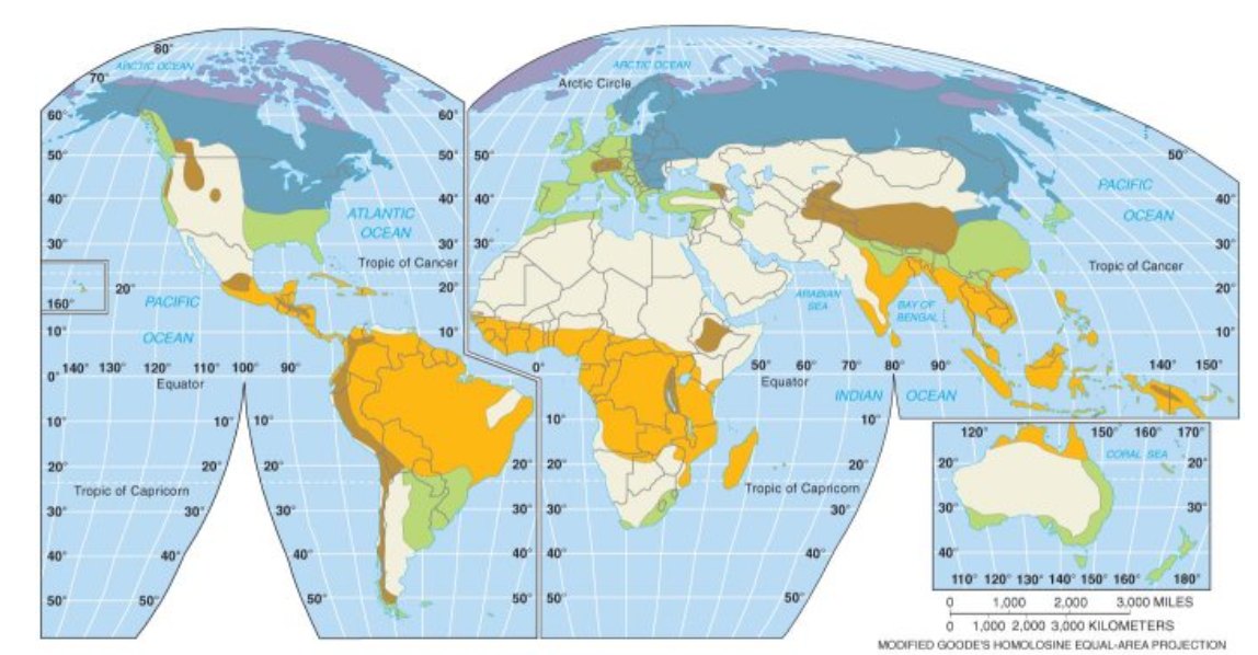
Slide "CLIMATIC REGIONS": a world map of climate regions A, B, C, D, E, H (the tropical 'A' region appears in orange over the Amazon, Central Africa, and Southeast Asia).
슬라이드 "기후 지역(CLIMATIC REGIONS)": 기후 구역 A, B, C, D, E, H를 나타낸 세계지도(열대 'A' 구역은 아마존, 중앙아프리카, 동남아시아에 걸쳐 주황색으로 표시됨).
2. Extensive subsistence: shifting cultivation 조방적 자급농업: 이동 경작
In shifting cultivation, farmers use a plot of land for a period of time, generally until the soil is depleted, and then leave it to its natural state to replenish and move on to another plot of land.
이동 경작(shifting cultivation)에서는 농민이 일정 기간(보통 토양이 고갈될 때까지) 한 땅을 쓰고, 그 땅을 자연 상태로 두어 회복시킨 뒤 다른 땅으로 옮겨 간다.
Shifting cultivation includes slash-and-burn agriculture: farmers clear land for planting by cutting down existing vegetation and burning the debris.
이동 경작에는 화전 농업(slash-and-burn)이 포함된다: 기존 식생을 베어 내고 잔해를 태워 파종할 땅을 개간한다.
Slash and burn agriculture is used in tropical regions of Latin America, Central Africa, and Southeast Asia ('A' (tropical) climate regions with high temperatures and abundant rainfall).
화전 농업은 라틴아메리카, 중앙아프리카, 동남아시아의 열대 지역('A'(열대) 기후 구역; 고온에 강수량이 풍부)에서 쓰인다.
Crops of shifting cultivation: Southeast Asia: Upland Rice. South America / Latin America: Maize, Manioc, Cassava. Sub-Saharan Africa: Millet, Sorghum, yams and vegetables.
이동 경작의 작물: 동남아시아: 밭벼(Upland Rice). 남아메리카/라틴아메리카: 옥수수(Maize), 마니옥(Manioc), 카사바(Cassava). 사하라 이남 아프리카: 기장(Millet), 수수(Sorghum), 얌(yams)과 채소.
3. Extensive subsistence: pastoral nomadism 조방적 자급농업: 유목
Pastoral Nomadism refers to the herding of domesticated animals, including camels, goats, sheep, and cattle, to produce food, clothing, and shelter for survival.
유목(Pastoral Nomadism)은 낙타, 염소, 양, 소 등 가축을 길러 생존을 위한 식량·의복·주거를 얻는 것이다.
Pastoral nomadism is mainly used in dry climates where planting crops is difficult or impossible, including Central and Southwest Asia, and North Africa.
유목은 주로 작물 재배가 어렵거나 불가능한 건조 기후(중앙·남서아시아, 북아프리카)에서 이루어진다.
Movements: not random, each group controls a certain area. Transhumance — seasonal migration of livestock between mountains and lowlands.
이동: 무작위가 아니며, 각 집단은 일정한 지역을 관리한다. 계절 이목(transhumance) — 가축이 산지와 저지대 사이를 계절적으로 이동하는 것.
Future of pastoral nomadism: a practical way of surviving on land that receives too little rain for the cultivation of crops, but declining. Governments often try to get the nomads to settle down to free the land for other uses like irrigated agriculture, mining, and petroleum.
유목의 미래: 작물 재배에 비가 너무 적게 오는 땅에서 생존하는 실용적 방법이지만 쇠퇴하고 있다. 정부는 관개 농업, 광업, 석유 등 다른 용도로 땅을 비우기 위해 유목민을 정착시키려 하는 경우가 많다.
4. Intensive subsistence: wet rice and other 집약적 자급농업: 벼농사와 그 밖의 형태
Intensive subsistence agriculture is characterized by the use of a small amount of land to produce food for one's immediate family or community.
집약적 자급농업(intensive subsistence agriculture)은 적은 면적의 땅으로 자기 가족이나 공동체를 위한 식량을 생산하는 것이 특징이다.
Most work is done by hand, with little use of machines. It tends to be located in the densely populated regions of Asia, Africa, and Latin America.
대부분의 일은 손으로 하며 기계는 거의 쓰지 않는다. 아시아, 아프리카, 라틴아메리카의 인구 밀집 지역에 위치하는 경향이 있다.
It can be divided into areas in which wet rice is dominant and areas where rice is not dominant.
이는 벼농사(wet rice)가 우세한 지역과 벼가 우세하지 않은 지역으로 나뉜다.
Wet rice is the dominant type of agriculture in East and Southeast China, and India. It is a labor-intensive practice done by, and with, the entire family, *double cropping.
벼농사는 중국 동부·남동부와 인도에서 지배적인 농업 형태이다. 온 가족이 함께 하는 노동집약적 방식이며, *이모작(double cropping)을 한다.
Intensive subsistence agriculture in which rice is not dominant is most common in areas with less consistent rainfall. The most common crops are wheat and barley. This is often practiced in northern China, *crop rotation.
벼가 우세하지 않은 집약적 자급농업은 강수가 덜 일정한 지역에서 가장 흔하다. 가장 흔한 작물은 밀과 보리이다. 중국 북부에서 자주 행해지며, *윤작(crop rotation)을 한다.
Summary table: subsistence subtypes 요약표: 자급농업 하위유형
| Type 유형 | Extensive / intensive 조방/집약 | Crops / animals 작물·가축 | Where 지역 | Key feature 핵심 특징 |
|---|---|---|---|---|
| Shifting cultivation (slash-and-burn) 이동 경작(화전) | Extensive 조방 | Upland rice (SE Asia); maize, manioc, cassava (Latin America); millet, sorghum, yams, vegetables (Sub-Saharan Africa) 밭벼; 옥수수·마니옥·카사바; 기장·수수·얌·채소 | Tropical 'A' regions of Latin America, Central Africa, SE Asia 라틴아메리카·중앙아프리카·동남아 열대 'A' | Use a plot until soil is depleted, then move on 토양이 고갈될 때까지 쓰고 이동 |
| Pastoral nomadism 유목 | Extensive 조방 | Camels, goats, sheep, cattle 낙타·염소·양·소 | Dry climates: Central and Southwest Asia, North Africa 건조 기후: 중앙·남서아시아, 북아프리카 | Herding; transhumance; declining 가축 방목; 계절 이목; 쇠퇴 중 |
| Intensive subsistence, wet rice dominant 집약적 자급, 벼농사 우세 | Intensive 집약 | Rice 벼 | East and Southeast China, India 중국 동부·남동부, 인도 | Labor-intensive, whole family, double cropping 노동집약, 온 가족, 이모작 |
| Intensive subsistence, rice not dominant 집약적 자급, 벼 비우세 | Intensive 집약 | Wheat and barley 밀·보리 | Areas with less consistent rainfall, e.g., northern China 강수가 덜 일정한 지역, 예: 중국 북부 | Crop rotation 윤작 |
Exam tip: Shifting cultivation (cultivating, then moving the plot; tropical 'A' climates) ≠ pastoral nomadism (herding animals; dry climates). Wet rice dominant (double cropping, E/SE China and India) ≠ rice not dominant (wheat and barley, crop rotation, less consistent rainfall).
시험 팁: 이동 경작(경작지를 바꿔 가며 재배; 열대 'A' 기후) ≠ 유목(가축 방목; 건조 기후). 벼농사 우세(이모작; 중국 동·남동부, 인도) ≠ 벼 비우세(밀·보리, 윤작, 강수 불규칙).
Commercial Agricultural Economies & the Von Thünen Model 상업적 농업 경제와 튀넨 모델
1. Commercial agricultural economies 상업적 농업 경제
Target Region: (MDCs) & Global Agribusiness.
대상 지역: (선진국, MDCs)과 글로벌 농기업(agribusiness).
Core Concept: Large-scale food production aimed at off-farm sales and profit maximization in local and global markets.
핵심 개념: 농장 밖 판매와 지역·세계 시장에서의 이윤 극대화를 목표로 하는 대규모 식량 생산.
High Capital, Low Labor: Driven by heavy machinery (tractors, combine harvesters), drones, synthetic fertilizers, and advanced technology.
높은 자본, 낮은 노동: 중장비(트랙터, 콤바인), 드론, 합성 비료, 첨단 기술에 의해 움직인다.
Agribusiness & Monoculture: Dominated by large corporate entities (Agribusiness); widespread practice of single-crop cultivation (Monoculture <--> Intercropping).
농기업과 단일재배: 대기업(agribusiness)이 지배하며, 단일 작물 재배(단일재배, Monoculture; 반대 개념은 간작(Intercropping))가 널리 행해진다.
| Subsistence 자급 | Commercial 상업 | |
|---|---|---|
| Region 지역 | Primarily LDCs 주로 개발도상국 | MDCs and global agribusiness 선진국, 글로벌 농기업 |
| Purpose 목적 | Direct consumption and survival of the farmer's family 농민 가족의 직접 소비·생존 | Off-farm sales; profit maximization in local and global markets 농장 밖 판매; 이윤 극대화 |
| Inputs 투입 | Low capital, high labor 낮은 자본, 높은 노동 | High capital, low labor 높은 자본, 낮은 노동 |
| Scale 규모 | Small landholdings, little to no marketable surplus 소규모, 판매용 잉여 거의 없음 | Large-scale; large corporate entities 대규모; 대기업 |
| Types 유형 | Extensive: shifting cultivation, nomadic herding. Intensive: wet rice dominant 조방: 이동 경작, 유목. 집약: 벼농사 우세 | Intensive: truck farming, mixed crop/livestock, dairy, Mediterranean, plantation. Extensive: large-scale grain, livestock ranching 집약: 트럭 농업·혼합·낙농·지중해성·플랜테이션. 조방: 대규모 곡물·방목 목축 |
2. Spatial organization: Von Thünen Model 공간 조직: 튀넨 모델
The Von Thünen Model explains agricultural patterns based on Land Rent (Bid-Rent Theory) and Transportation Costs.
튀넨 모델(Von Thünen Model)은 지대(Land Rent; 입찰지대 이론, Bid-Rent Theory)와 운송비를 바탕으로 농업 패턴을 설명한다.
Core Principle: Land closer to the market is expensive, used for high-yield, perishable crops (Intensive). Land farther away is cheap, used for spatial-heavy farming (Extensive).
핵심 원리: 시장에 가까운 땅은 비싸서 수확량이 높고 상하기 쉬운 작물(집약)에 쓰인다. 멀리 있는 땅은 싸서 넓은 땅이 필요한 농업(조방)에 쓰인다.
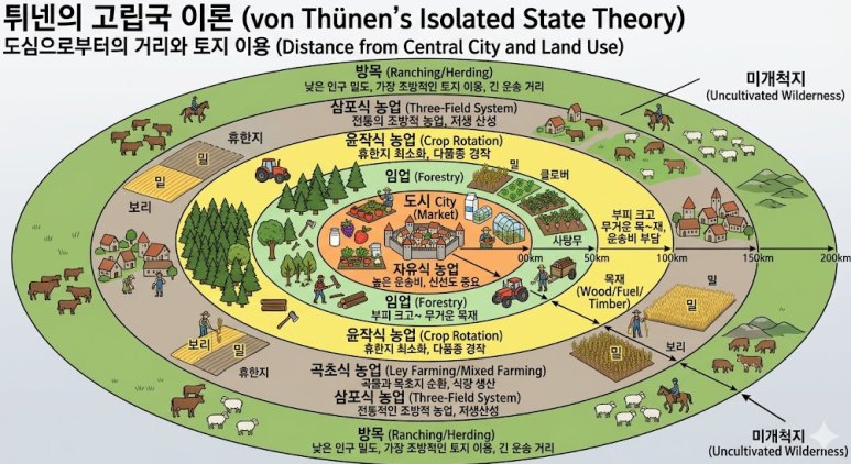
Rings Structure — Ring 1: Dairying & Horticulture (Highly perishable, high transport cost). Ring 2: Forestry/Firewood (Heavy to transport). Ring 3: Field Crops & Grains (Less perishable, easier transport). Ring 4: Livestock Ranching (Requires vast land; animals walk to market).
고리(Ring) 구조 — 1고리: 낙농과 원예(매우 상하기 쉽고 운송비가 높음). 2고리: 임업/땔감(운송하기 무거움). 3고리: 밭작물과 곡물(덜 상하고 운송이 쉬움). 4고리: 기업적 목축(넓은 땅 필요; 동물이 걸어서 시장으로 감).
Modern Modifications: Refrigerated transport, global supply chains, and improved infrastructure alter or blur these rigid concentric zones.
현대적 수정: 냉장 운송, 세계 공급망, 개선된 인프라가 이 엄격한 동심원 지대를 바꾸거나 흐릿하게 만든다.
| Ring 고리 | Land use / crop 토지 이용·작물 | Reason 이유 | Intensity 집약도 |
|---|---|---|---|
| 1 (closest to market) 1(시장에 가장 가까움) | Dairying & Horticulture 낙농·원예 | Highly perishable, high transport cost 매우 상하기 쉬움, 운송비 높음 | Most intensive 가장 집약 |
| 2 | Forestry/Firewood 임업·땔감 | Heavy to transport 운송하기 무거움 | – |
| 3 | Field Crops & Grains 밭작물·곡물 | Less perishable, easier transport 덜 상함, 운송 쉬움 | – |
| 4 (farthest) 4(가장 멂) | Livestock Ranching 기업적 목축 | Requires vast land; animals walk to market 넓은 땅 필요; 동물이 걸어서 시장으로 | Most extensive 가장 조방 |
Exam tip: The closer to the market, the higher the land rent and the more intensive and perishable the use. Learn the ring order exactly: 1 dairying/horticulture, 2 forestry/firewood, 3 field crops/grains, 4 livestock ranching. Ring-order swaps are the common distractor.
시험 팁: 시장에 가까울수록 지대가 높고 더 집약적이며 상하기 쉬운 작물이 온다. 고리 순서를 정확히 외울 것: 1 낙농·원예, 2 임업·땔감, 3 밭작물·곡물, 4 방목 목축. 순서를 바꾼 선지가 흔한 오답이다.
Von Thünen assumptions ("isolated state") 튀넨의 "고립국" 가정
Assumptions of von Thünen's "isolated state":
튀넨의 "고립국(isolated state)" 가정:
- single, self sufficient market center with no outside influence
외부 영향이 없는, 자급자족하는 하나의 시장 중심지 - soil quality and climate are consistent throughout the isolated state
고립국 전체에서 토양 질과 기후가 일정함 - flat and uninterrupted land without impediments to cultivation or transportation
경작이나 운송을 막는 장애물이 없는 평평하고 끊김 없는 땅 - farmers transport their own crops to the market center taking the straight, direct, route
농민이 직접 작물을 곧고 직선적인 경로로 시장 중심지까지 운송함 - therefore transport costs are directly proportional to distance (it costs more to transport longer distances)
따라서 운송비는 거리에 정비례함(먼 거리를 운송할수록 비용이 더 듦) - farmers want to maximize their profits by minimizing transportation costs
농민은 운송비를 최소화하여 이윤을 극대화하려 함
Description of F05: the Central City (black dot) is surrounded by rings (below).
F05 설명: 중심 도시(검은 점)를 여러 고리가 둘러싼다(아래).
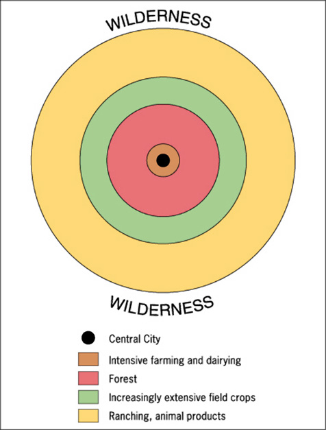
Slides p23–p24 show rent-vs-distance graphs of the Von Thünen model: (a) a single crop's bid-rent curve falling from O to X; (b) the land-use zonation model with two crop bid-rent lines (a and b) crossing at X — Crop A zone left of X, Crop B zone between X and Y.
슬라이드 p23~p24는 튀넨 모델의 지대-거리 그래프를 보여준다: (a) 한 작물의 입찰지대 곡선이 O에서 X로 내려감; (b) 두 작물의 입찰지대 선(a, b)이 X에서 교차하는 토지이용 지대 모델 — X 왼쪽은 작물 A 지대, X와 Y 사이는 작물 B 지대.
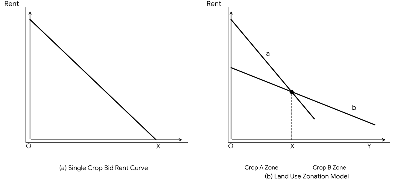
FIGURE 29: The von Thünen model illustrates why rents decline with accessibility and how competing land uses maximize rents. Net income (dollars) vs. kilometers from market: vegetables near the market (about 0–10 km), dairying (about 10–30 km), beef production (about 30–50 km).
그림 29: 튀넨 모델은 접근성에 따라 지대가 왜 하락하는지, 그리고 경쟁하는 토지 이용이 어떻게 지대를 극대화하는지 보여준다. 시장으로부터의 거리(km)에 따른 순소득(달러): 시장 근처는 채소(약 0~10km), 낙농(약 10~30km), 쇠고기 생산(약 30~50km).
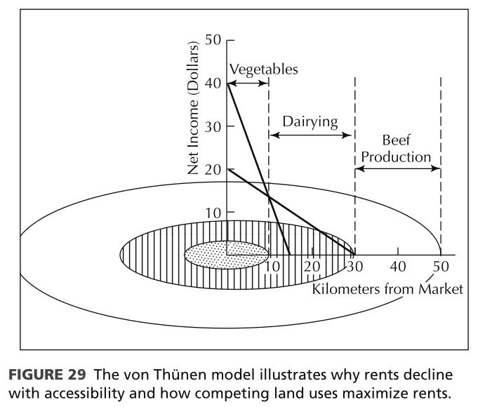
Illustrated Von Thünen "Isolated State Theory" (Distance from Central City and Land Use), with market city at the center and uncultivated wilderness outside; distance scale 50–200 km. Rings from the center outward (Korean labels on the slide):
튀넨의 고립국 이론(중심 도시로부터의 거리와 토지 이용) 삽화: 중심에 시장 도시, 바깥은 미개척지(Uncultivated Wilderness); 거리 눈금 50~200km. 중심에서 바깥으로(슬라이드의 한국어 라벨):
- City (Market) — Free farming ("자유식 농업"; Korean label only on the slide): high transport cost, freshness is key
도시(시장) — 자유식 농업(슬라이드에는 한국어 라벨만 있음): 높은 운송비, 신선도 중요 - Forestry (wood/fuel/timber): bulky and heavy
임업(목재·연료): 부피 크고 무거운 목재 - Crop rotation: minimal fallow, diverse cropping
윤작식 농업: 휴한지 최소화, 다품종 경작 - Ley farming / mixed farming: rotation of grain and pasture, food production
곡초식 농업: 곡물과 목초지 순환, 식량 생산 - Three-field system: traditional extensive farming, low productivity
삼포식 농업: 전통적인 조방적 농업, 저생산성 - Ranching/herding: low population density, the most extensive land use, long transport distance
방목: 낮은 인구 밀도, 가장 조방적인 토지 이용, 긴 운송 거리
⚠ Note: the slide-p21 ring list (4 rings) and the illustration F08 (more labeled bands, e.g., crop rotation, ley farming, three-field system) differ in detail. For exam answers use the p21 four-ring list; F08 is supplementary.
참고: 슬라이드 p21의 고리 목록(4개)과 삽화 F08(윤작식·곡초식·삼포식 등 더 세분된 띠)은 세부가 다르다. 시험 답은 p21의 4고리 목록을 기준으로 하고, F08은 보충으로 본다.
3. Intensive commercial agriculture 집약적 상업 농업
Intensive commercial agriculture relies on large amounts of both money and labor that produce crops with high yields and high market value per unit of land.
집약적 상업 농업(intensive commercial agriculture)은 많은 자금과 노동에 의존하며, 단위 면적당 수확량과 시장 가치가 높은 작물을 생산한다.
Types of intensive commercial agriculture include: truck farming; mixed livestock and crop farming; dairy farming; Mediterranean agriculture; plantation agriculture.
집약적 상업 농업의 유형: 트럭 농업(truck farming); 혼합 가축·작물 농업; 낙농(dairy farming); 지중해성 농업(Mediterranean agriculture); 플랜테이션 농업(plantation agriculture).
4. Extensive commercial agriculture 조방적 상업 농업
Extensive commercial agriculture refers to agricultural goods produced on large farms with small amounts of money and labor spent per unit of land.
조방적 상업 농업(extensive commercial agriculture)은 단위 면적당 투입되는 자금과 노동이 적은 대규모 농장에서 농산물을 생산하는 것이다.
Examples of extensive commercial agriculture include: large-scale grain farming; livestock ranching.
조방적 상업 농업의 예: 대규모 곡물 농업; 기업적 목축(livestock ranching).
| Intensive commercial 집약적 상업 | Extensive commercial 조방적 상업 | |
|---|---|---|
| Inputs per unit of land 단위 면적당 투입 | Large amounts of money and labor 많은 자금·노동 | Small amounts of money and labor, large farms 적은 자금·노동, 대규모 농장 |
| Output 산출 | High yields, high market value per unit of land 높은 수확량·시장 가치 | Agricultural goods produced on large farms 대규모 농장에서 생산 |
| Types 유형 | Truck farming, mixed livestock and crop, dairy, Mediterranean, plantation 트럭 농업, 혼합 가축·작물, 낙농, 지중해성, 플랜테이션 | Large-scale grain farming, livestock ranching 대규모 곡물 농업, 방목 목축 |
Exam tip: Intensive commercial (truck farming, dairy, Mediterranean, plantation…) uses a lot of money and labor per unit of land; extensive commercial (grain, ranching) uses little per unit of land on large farms. Also keep the Von Thünen assumptions straight: ONE market, uniform soil and climate, flat land, direct routes, transport cost proportional to distance, profit-maximizing farmers. Modern modifications (refrigeration, global supply chains) blur the rings.
시험 팁: 집약적 상업(트럭 농업·낙농·지중해성·플랜테이션 등)은 단위 면적당 자금·노동이 많고, 조방적 상업(곡물·방목)은 대규모 농장에서 단위 면적당 투입이 적다. 튀넨 가정도 정확히: 시장 하나, 균일한 토양·기후, 평평한 땅, 직선 경로, 운송비는 거리에 비례, 이윤 극대화 농민. 현대적 수정(냉장·세계 공급망)은 고리를 흐릿하게 한다.
The 7 Major Types of Commercial Agriculture 상업농 7유형
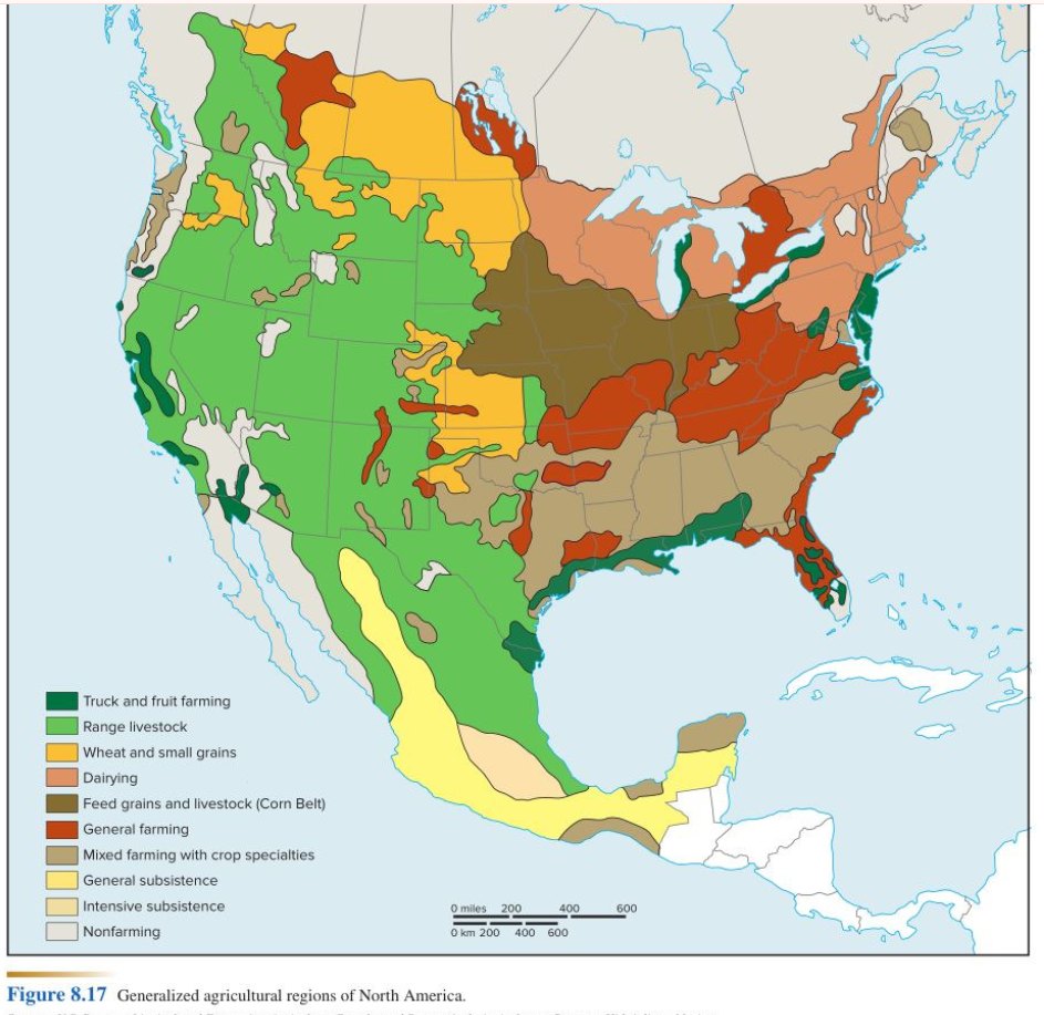
Slide p29/p37: map of generalized agricultural regions of North America (F09).
슬라이드 p29/p37: 북미의 일반화된 농업 지역(agricultural regions) 지도(F09).
1. Mixed Crop and Livestock 혼합 농업 (지도 6)
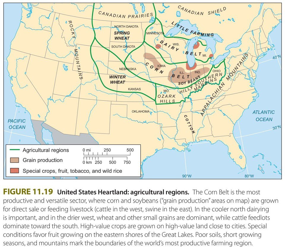
Characteristics: Integration of crops and livestock on the same farm; most of the crops grown (e.g., corn and soybeans) are fed directly to animals rather than consumed by humans.
특징: 같은 농장에서 작물과 가축을 결합(integration)한다. 재배하는 작물(예: 옥수수, 대두)의 대부분은 사람이 먹는 것이 아니라 동물에게 직접 사료로 먹인다.
Economic Aspects: Most revenue is derived from livestock products (e.g., beef, pork, eggs), which permits a more even distribution of income throughout the year.
경제적 측면: 수입의 대부분이 가축 생산물(예: 쇠고기, 돼지고기, 달걀)에서 나오며, 이 덕분에 연중 소득이 더 고르게 분배된다.
Key Regions: The U.S. Midwest (the Corn Belt) and Western Europe.
주요 지역: 미국 중서부(콘 벨트, Corn Belt)와 서유럽.
Region: U.S. between the Great Plains and the Appalachian Mountains; Europe from France to Russia. Benefit: more even distribution of work and income throughout the year.
지역: 미국에서는 대평원(Great Plains)과 애팔래치아 산맥(Appalachian Mountains) 사이, 유럽에서는 프랑스에서 러시아까지. 이점: 연중 일과 소득이 더 고르게 분배된다.
Crops: Corn and Soybeans – U.S. Corn Belt from Ohio to the Dakotas. Livestock: Cattle, Pigs.
작물: 옥수수와 대두 – 오하이오에서 다코타까지의 미국 콘 벨트. 가축: 소, 돼지.
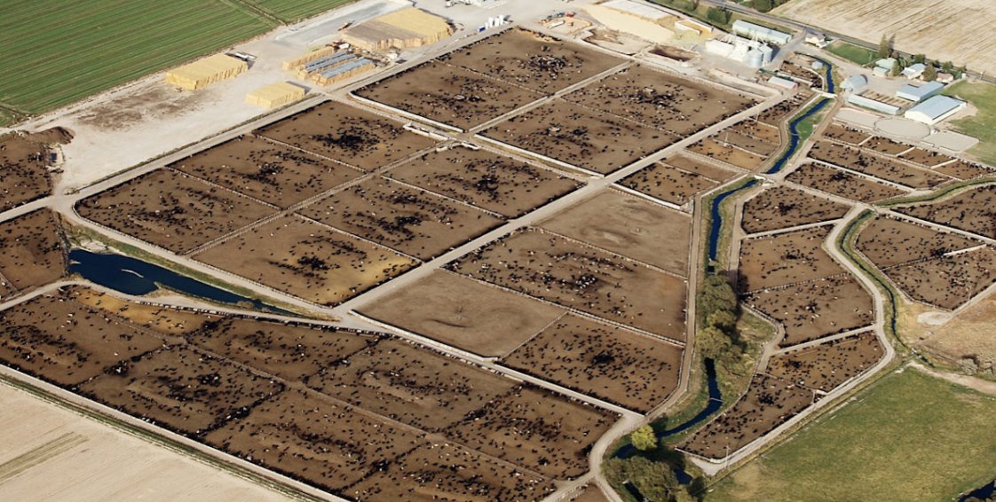
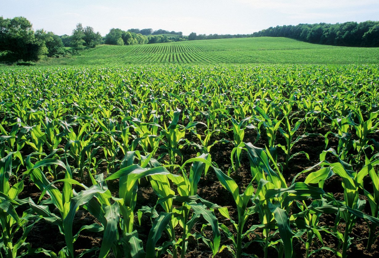
Feed-crop cultivation: vast corn and soybean fields stretching to the horizon. Integrated livestock facilities: a large modern pig farm and barn (CAFO) in the middle of farmland. Corn harvest, then livestock feed, then manure recycled as fertilizer for the fields. Linked to agriculture, livestock, and the food and bio-fuel (ethanol) industries that process them.
사료 작물 재배: 지평선 끝까지 펼쳐진 광활한 옥수수·대두(콩) 경작지. 결합된 축산 시설: 농경지 한가운데 자리 잡은 대규모 현대식 양돈장·축사(Barn/CAFO). 친환경 선순환: 옥수수 수확 → 가축 사료 공급 → 가축 분뇨를 경작지 비료로 재활용. 농업·축산업, 그리고 이를 가공하는 식품·바이오 연료(에탄올) 제조업과 연계된다.
2. Dairy Farming 낙농업 (지도 7)
Characteristics: Specializes in the production of milk, butter, cheese, and other dairy products; highly perishable, making market proximity critical.
특징: 우유, 버터, 치즈 등 유제품 생산에 특화한다. 매우 상하기 쉬워서(highly perishable) 시장과의 근접성이 결정적이다.
Milkshed: The ring surrounding a city from which milk can be supplied without spoiling (traditionally located in Ring 1 of the Von Thünen model).
밀크셰드(Milkshed): 우유가 상하지 않고 공급될 수 있는, 도시를 둘러싼 고리 지역(전통적으로 튀넨 모델(Von Thünen model)의 1번 고리에 위치).
Key Regions: Northeastern United States, Western Europe, and New Zealand.
주요 지역: 미국 북동부, 서유럽, 뉴질랜드.
3. Mediterranean Agriculture 지중해성 농업 (지도 10)
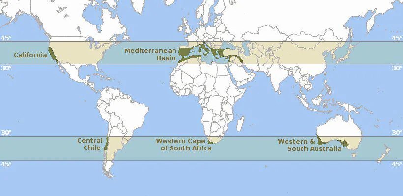
Characteristics: Practiced in regions sharing a Mediterranean climate (hot, dry summers and mild, wet winters). Relies on a combination of rain-fed winter crops, drought-resistant summer tree crops, and irrigation.
특징: 지중해성 기후(뜨겁고 건조한 여름, 온화하고 습한 겨울)를 공유하는 지역에서 이루어진다. 비로 자라는 겨울 작물, 가뭄에 강한 여름 수목 작물, 관개(irrigation)를 결합해 의존한다.
Key Crops: Olives, grapes, citrus fruits, figs, and tree nuts (e.g., almonds).
주요 작물: 올리브, 포도, 감귤류, 무화과, 견과류(예: 아몬드).
Key Regions: Mediterranean Basin (Southern Europe, North Africa, and the Middle East), Coastal California (United States), Central Chile, Southwestern South Africa, Southwestern and Southern Australia.
주요 지역: 지중해 연안(남유럽, 북아프리카, 중동), 미국 캘리포니아 해안, 칠레 중부, 남아프리카 남서부, 호주 남서부와 남부.
4. Commercial Gardening and Fruit Farming 상업적 원예·과수 농업 (Market Gardening / Truck Farming)
Characteristics: Intensive farming focused on growing high-demand fresh fruits, vegetables, and flowers for urban consumer markets; widely referred to as Truck Farming.
특징: 도시 소비 시장을 위해 수요가 높은 신선한 과일, 채소, 꽃을 기르는 집약적 농업으로, 흔히 트럭 농업(Truck Farming)이라 부른다.
Economic & Operational Aspects: Highly intensive (both capital- and labor-intensive); relies heavily on specialized machinery, seasonal/migrant labor, and efficient transport networks (e.g., cold chain).
경제·운영 측면: 매우 집약적(자본 집약적이면서 노동 집약적)이며, 특수 기계, 계절·이주 노동력, 효율적인 수송망(예: 콜드 체인)에 크게 의존한다.
Key Regions: Located near major metropolitan areas or in climatically favorable coastal/sunbelt regions. United States: California, Florida, and the Mid-Atlantic/East Coast. Europe: Western & Southern Europe (e.g., Mediterranean coast, Netherlands).
주요 지역: 대도시권 근처 또는 기후가 유리한 해안·선벨트 지역. 미국: 캘리포니아, 플로리다, 중부 대서양·동부 해안. 유럽: 서유럽과 남유럽(예: 지중해 연안, 네덜란드).
5. Commercial Grain Farming 상업적 곡물 농업 (지도 8)
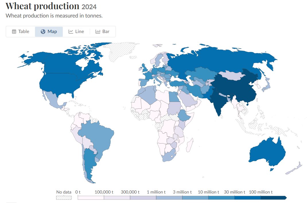
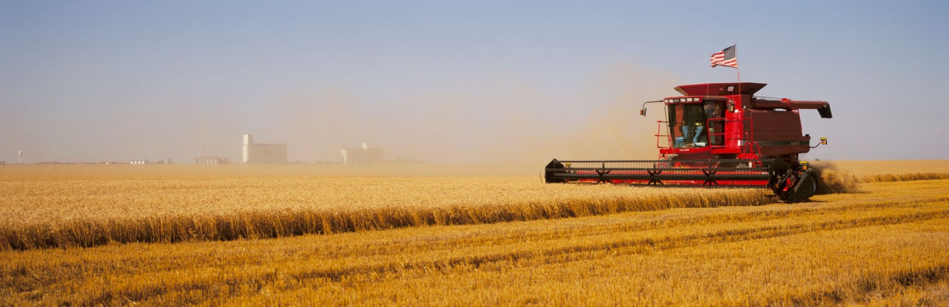
Characteristics: Large-scale cultivation of cereal grains (primarily wheat) intended for market sale and global export; characterized by extreme mechanization (e.g., combine harvesters) and low labor input per acre, and extensive land use with low yields per unit area but high output per worker.
특징: 시장 판매와 세계 수출을 위해 곡물(주로 밀)을 대규모로 재배한다. 극도의 기계화(예: 콤바인)와 에이커당 적은 노동 투입이 특징이며, 조방적(extensive) 토지 이용으로 단위 면적당 수확량은 낮지만 노동자 1인당 산출량은 높다.
Regional Belt Classifications (North America):
지역별 지대 구분(북미):
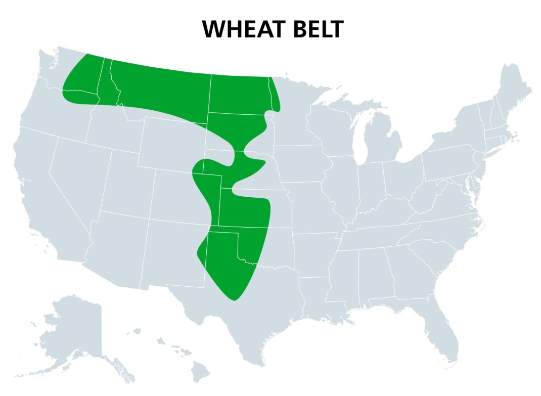
Spring Wheat Belt: Crop planted in spring and harvested in late summer due to severe winters (e.g., North Dakota, South Dakota, Montana, and Canadian Prairie provinces).
봄밀 지대(Spring Wheat Belt): 혹독한 겨울 때문에 봄에 파종해 늦여름에 수확한다(예: 노스다코타, 사우스다코타, 몬태나, 캐나다 프레리 주들).
Winter Wheat Belt: Crop planted in autumn, survives the winter, and is harvested in early summer (e.g., Kansas, Oklahoma, Texas).
겨울밀 지대(Winter Wheat Belt): 가을에 파종해 겨울을 나고 초여름에 수확한다(예: 캔자스, 오클라호마, 텍사스).
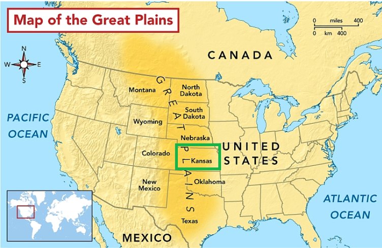
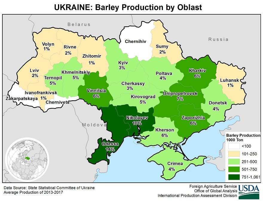
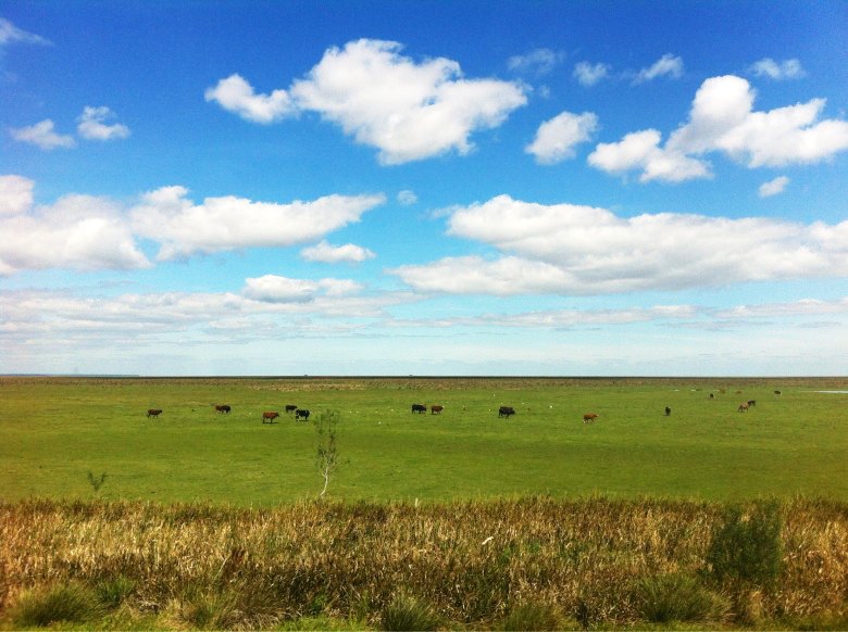
Key Regions: North America: U.S. and Canadian Great Plains. Eurasia: Steppes of Ukraine, Russia, and Kazakhstan. Southern Hemisphere: Pampas of Argentina, Southwestern & Southeastern Australia.
주요 지역: 북미: 미국·캐나다 대평원. 유라시아: 우크라이나, 러시아, 카자흐스탄의 스텝(Steppes). 남반구: 아르헨티나 팜파스(Pampas), 호주 남서부·남동부.
Commercial Grain Farming – Great Plains (the natural environment of the United States).
상업적 곡물 농업 – 대평원(미국의 자연환경).
6. Livestock Ranching 기업적 목축
Characteristics: Commercial grazing of livestock (cattle and sheep) over extensive areas of arid or semi-arid land where crop production is difficult; an extensive commercial land use practice with low inputs per unit of land.
특징: 작물 재배가 어려운 건조·반건조 지대의 넓은 지역에서 가축(소와 양)을 상업적으로 방목한다. 단위 토지당 투입이 적은 조방적 상업 토지 이용이다.
Economic & Spatial Aspects: Operates on low-cost, remote land with low land rent (traditionally located in the outermost Ring 4 of the Von Thünen model). Modern infrastructure (refrigerated transport, livestock trucks/rail) now allows remote ranches to process meat locally and export globally.
경제·공간 측면: 지대(land rent)가 낮은 값싼 외딴 땅에서 운영한다(전통적으로 튀넨 모델의 가장 바깥 4번 고리). 현대의 기반 시설(냉장 수송, 가축 트럭·철도) 덕분에 외딴 목장도 현지에서 고기를 가공해 전 세계로 수출할 수 있다.
Key Regions – Cattle Ranching: Western United States, Argentine Pampas, Southern Brazil, and Northern Australia.
주요 지역 – 소 목축: 미국 서부, 아르헨티나 팜파스, 브라질 남부, 호주 북부.
Key Regions – Sheep Ranching: Interior/Southern Australia, New Zealand, and Patagonia (Argentina/Chile).
주요 지역 – 양 목축: 호주 내륙·남부, 뉴질랜드, 파타고니아(아르헨티나/칠레).
7. Plantation Agriculture 플랜테이션 농업
Characteristics: A specialized form of commercial agriculture practiced in tropical/subtropical Developing Countries (LDCs), but historically rooted in European colonialism and currently often owned/managed by transnational corporations based in Developed Countries (MDCs).
특징: 열대·아열대 개발도상국(LDCs)에서 이루어지는 특화된 상업농이지만, 역사적으로는 유럽 식민주의(colonialism)에 뿌리를 두며, 현재는 선진국(MDCs)에 본사를 둔 초국적 기업(transnational corporations)이 소유·관리하는 경우가 많다.
Operational Structure: Monoculture focus: specializes in the large-scale monoculture of a single Cash Crop (e.g., coffee, sugarcane, cocoa, bananas, rubber, tea, palm oil, cotton) grown primarily for export to MDC markets using low-cost local labor.
운영 구조: 단일재배(monoculture) 중심. 하나의 환금작물(cash crop, 예: 커피, 사탕수수, 카카오, 바나나, 고무, 차, 팜유, 면화)을 대규모로 단일재배해, 값싼 현지 노동력으로 주로 선진국 시장에 수출한다.
Vulnerabilities: Highly susceptible to global market price fluctuations and ecological risks (e.g., soil depletion, widespread crop disease due to monoculture).
취약점: 세계 시장 가격 변동과 생태적 위험(예: 토양 고갈, 단일재배로 인한 광범위한 작물 병해)에 매우 취약하다.
Key Regions & crops: Latin America: bananas, coffee, sugarcane, soybeans. Sub-Saharan Africa: cocoa, coffee. South & Southeast Asia: natural rubber, tea, sugarcane.
주요 지역과 작물: 라틴아메리카: 바나나, 커피, 사탕수수, 대두. 사하라 이남 아프리카: 카카오, 커피. 남아시아·동남아시아: 천연고무, 차, 사탕수수.
Summary table: the 7 types of commercial agriculture. Von Thünen ring links are stated only where the slides state them (Dairy Ring 1, Ranching Ring 4).
요약표: 상업농 7유형. 튀넨 링 연관은 슬라이드가 밝힌 경우(낙농 1번 고리, 목축 4번 고리)만 적었다.
| Type 유형 | Key characteristic 핵심 특징 | Key regions 주요 지역 | Von Thünen link 튀넨 링 연관 |
|---|---|---|---|
| 1 Mixed crop & livestock 혼합 농업 | Crops fed to animals; revenue mostly from livestock; even income 작물을 가축에게 먹임, 수입 대부분 가축, 소득 고름 | U.S. Corn Belt, Western Europe 미국 콘 벨트, 서유럽 | Not stated on the slides 슬라이드에 언급 없음 |
| 2 Dairy 낙농업 | Milk, butter, cheese; highly perishable; milkshed 우유·버터·치즈, 상하기 쉬움, 밀크셰드 | NE United States, Western Europe, New Zealand 미국 북동부, 서유럽, 뉴질랜드 | Ring 1 (near the city) 1번 고리(도시 가까이) |
| 3 Mediterranean 지중해성 농업 | Mediterranean climate; olives, grapes, citrus, figs, tree nuts 지중해성 기후, 올리브·포도·감귤·무화과·견과 | Mediterranean Basin, California, Central Chile, SW South Africa, SW/S Australia 지중해 연안, 캘리포니아, 칠레 중부, 남아공 남서부, 호주 남서·남부 | Not stated on the slides 슬라이드에 언급 없음 |
| 4 Commercial gardening / fruit (truck farming) 상업적 원예·과수(트럭 농업) | Intensive; fresh fruit, vegetables, flowers for urban markets; cold chain 집약적, 도시 시장용 신선 과일·채소·꽃, 콜드 체인 | Near big cities or favorable coastal/sunbelt areas (California, Florida, Netherlands) 대도시 근처·유리한 해안/선벨트(캘리포니아, 플로리다, 네덜란드) | Not stated on the slides 슬라이드에 언급 없음 |
| 5 Commercial grain 상업적 곡물 농업 | Wheat; extreme mechanization; extensive; low yield per area, high output per worker 밀, 극도의 기계화, 조방적, 면적당 수확 낮고 1인당 산출 높음 | Great Plains, Steppes (Ukraine, Russia, Kazakhstan), Pampas, Australia 대평원, 스텝(우크라이나·러시아·카자흐스탄), 팜파스, 호주 | Not stated on the slides 슬라이드에 언급 없음 |
| 6 Livestock ranching 기업적 목축 | Grazing cattle and sheep on arid/semi-arid land; low land rent 건조·반건조 지대 소·양 방목, 낮은 지대 | W. United States, Pampas, S. Brazil, N. Australia; sheep: Australia, New Zealand, Patagonia 미국 서부, 팜파스, 브라질 남부, 호주 북부; 양: 호주, 뉴질랜드, 파타고니아 | Outermost Ring 4 가장 바깥 4번 고리 |
| 7 Plantation 플랜테이션 | Monoculture cash crop for export; colonial roots; MDC corporations 환금작물 단일재배·수출, 식민 뿌리, 선진국 기업 | Latin America, Sub-Saharan Africa, South & Southeast Asia 라틴아메리카, 사하라 이남 아프리카, 남·동남아시아 | Not stated on the slides 슬라이드에 언급 없음 |
⚠ Note: the slide labels the types with map numbers (Mixed = map 6, Dairy = map 7, Grain = map 8, Mediterranean = map 10). These follow the F03 legend numbering (6 mixed, 7 dairy, 8 grain, 9 livestock ranching, 10 Mediterranean, 11 commercial gardening, 12 plantation).
⚠ 참고: 슬라이드는 유형 옆에 지도 번호(혼합 = 지도 6, 낙농 = 지도 7, 곡물 = 지도 8, 지중해성 = 지도 10)를 적었다. 이는 F03 범례 번호(6 혼합, 7 낙농, 8 곡물, 9 목축, 10 지중해성, 11 상업적 원예, 12 플랜테이션)와 같은 체계다.
Exam tip (Mixed vs Dairy vs Ranching): Mixed = crops fed to animals on the same farm, income spread over the year. Dairy = perishable milk, so near the market (Ring 1, milkshed). Ranching = extensive grazing on arid land with low land rent (Ring 4).
시험 팁(혼합 vs 낙농 vs 목축): 혼합 = 같은 농장에서 작물을 가축에게 먹이고 소득이 연중 고르다. 낙농 = 우유는 상하기 쉬워 시장 가까이(1번 고리, 밀크셰드). 목축 = 건조 지대의 조방적 방목, 낮은 지대(4번 고리).
Exam tip (Mediterranean vs Commercial gardening): Mediterranean is defined by climate (hot, dry summers; mild, wet winters) and tree crops such as olives and grapes. Commercial gardening is defined by urban fresh-produce markets (truck farming), near big cities or favorable coastal/sunbelt areas.
시험 팁(지중해성 vs 상업적 원예): 지중해성은 기후(뜨겁고 건조한 여름, 온화하고 습한 겨울)와 올리브·포도 같은 수목 작물로 정의된다. 상업적 원예는 도시의 신선 농산물 시장(트럭 농업)으로 정의되며 대도시 근처나 유리한 해안·선벨트에 있다.
Exam tip (Spring vs Winter wheat): Spring wheat = planted in spring, harvested late summer, severe winters (Dakotas, Montana, Canadian Prairie). Winter wheat = planted in autumn, survives the winter, harvested early summer (Kansas, Oklahoma, Texas). Grain farming is extensive: low yield per unit area but high output per worker.
시험 팁(봄밀 vs 겨울밀): 봄밀 = 봄 파종, 늦여름 수확, 혹독한 겨울(다코타, 몬태나, 캐나다 프레리). 겨울밀 = 가을 파종, 겨울을 나고 초여름 수확(캔자스, 오클라호마, 텍사스). 곡물 농업은 조방적이라 단위 면적당 수확은 낮고 노동자 1인당 산출은 높다.
Whittlesey's Agricultural Regions Whittlesey의 세계 농업 지역 (11개 요약)
Summary D. Whittlesey's world agricultural regions (11-region summary). Part 1: Developing-country-centered regions (subsistence / traditional agriculture): 5 regions.
정리 D. Whittlesey의 세계 농업 지역(11개 요약). 1부: 개발도상국 중심(자급적·전통적 농업) 5개 지역.
| Region (English) 지역 | Where / key feature 분포 / 핵심 특징 |
|---|---|
| 1. Shifting Cultivation 이동 경작(슬라이드 표기: 이동식 구농업 ⚠ 오기로 보임) | Tropical rainforest zone; slash-and-burn method 열대 우림 지대, 화전(Slash-and-burn) 방식 |
| 2. Nomadic Pastoralism 유목 | Arid and semi-arid zones; moves with livestock in search of oases or grass 건조·반건조 지대, 오아시스나 풀을 찾아 가축과 이동 |
| 3. Intensive Subsistence, Rice Dominant 집약적 자급 벼농사 | Monsoon Asia; maximizes land-use rate and labor per unit area 계절풍(몬순) 아시아, 경지 이용률 및 단위면적당 노동력 극대화 |
| 4. Intensive Subsistence, Non-Rice 집약적 자급 밭농사 | Inland and northern East Asia; wheat, soybean, and corn in dry or cold areas 동아시아 내륙·북부, 건조하거나 추운 지역의 밀·콩·옥수수 재배 |
| 5. Plantation 플랜테이션 | Tropical and subtropical zones; developed-country capital and technology plus local labor (tea, coffee, rubber, cacao; commercial export) 열대·아열대 지대, 선진국 자본·기술 + 현지 노동력(차, 커피, 고무, 카카오 등 상업적 수출) |
Slide wording: "Intensive Subsistence, Rice Dominant" is on a rice-dominant monsoon-Asia basis; "Non-Rice" covers wheat, soybean, and corn in dry or cold inland and northern East Asia.
슬라이드 표현: "집약적 자급 벼농사(Rice Dominant)"는 벼가 우세한 몬순 아시아, "밭농사(Non-Rice)"는 건조하거나 추운 동아시아 내륙·북부의 밀·콩·옥수수 재배를 가리킨다.
Part 2: Developed-country-centered regions (commercial agriculture): 6 regions.
2부: 선진국 중심(상업적 농업) 6개 지역.
| Region (English) 지역 | Where / key feature 분포 / 핵심 특징 |
|---|---|
| 1. Commercial Gardening / Truck Farming 상업적 원예 및 과수 | Near big cities; fresh vegetables, fruit, flowers (intensive, refrigerated transport) 대도시 인근, 신선 채소·과일·꽃(집약적, 냉장 수송) |
| 2. Commercial Grain Farming 상업적 곡물 농업 | Temperate grasslands (Great Plains, steppes); wheat-centered, large-scale mechanization (extensive) 온대 초원(대평원, 스텝), 밀 중심, 대규모 기계화(Extensive) |
| 3. Commercial Dairying 상업적 낙농업 | Northeastern North America, Northern Europe; near cities (milk), far away (cheese, butter) 북미 북동부, 북유럽, 도시 근교(우유), 원거리(치즈·버터) |
| 4. Mixed Crop & Livestock 상업적 혼합 농업 | U.S. Corn Belt, Western Europe; feed-crop growing + raising livestock (pigs, cattle) 미국 옥수수 지대(Corn Belt), 서유럽, 사료 작물 재배 + 가축(돼지·소) 사육 |
| 5. Livestock Ranching 기업적 목축 | Dry grasslands (western U.S., Pampas, Australia); large-scale grazing of cattle and sheep 건조 초원(미국 서부, 팜파스, 호주), 소·양 대규모 방목 |
| 6. Mediterranean Agriculture 지중해성 농업 | Mediterranean coast, California; summer: tree gardening (olives, grapes) 지중해 연안, 캘리포니아, 여름: 수목 원예(올리브, 포도) |
The slide text for this last row ends after "olives, grapes"; nothing more is given.
이 마지막 행의 슬라이드 문장은 "올리브, 포도"에서 끝나며 그 이상은 주어져 있지 않다.
The world map (F03) is the original Whittlesey map for number questions. Its legend: 1 little/no agriculture; Subsistence (LDCs): 2 shifting cultivation, 3 intensive subsistence wet rice dominant, 4 intensive subsistence wet rice not dominant, 5 pastoral nomadism; Commercial (MDCs): 6 mixed crop and livestock, 7 dairy, 8 grain, 9 livestock ranching, 10 Mediterranean, 11 commercial gardening; LDCs: 12 plantation.
세계 지도(F03)는 번호 문제에서 기준이 되는 Whittlesey 지도다. 범례: 1 농업이 거의 없음; 자급(LDCs): 2 이동경작, 3 집약적 자급 벼농사(벼 우세), 4 집약적 자급(벼 우세하지 않음), 5 유목(pastoral nomadism); 상업(MDCs): 6 혼합 농업, 7 낙농, 8 곡물, 9 목축, 10 지중해성, 11 상업적 원예; LDCs: 12 플랜테이션.
| F03 legend no. F03 범례 번호 | F03 region F03 지역 | In the "11 summary"? 11개 요약에 있나? |
|---|---|---|
| 1 | Little/no agriculture 농업 거의 없음 | No (not a farming type) 없음(농업 유형이 아님) |
| 2 | Shifting cultivation 이동경작 | Yes, developing 1 있음, 개도국 1 |
| 3 | Intensive subsistence, wet rice dominant 집약적 자급, 벼 우세 | Yes, developing 3 있음, 개도국 3 |
| 4 | Intensive subsistence, wet rice not dominant 집약적 자급, 벼 우세하지 않음 | Yes, developing 4 ("Non-Rice") 있음, 개도국 4("밭농사") |
| 5 | Pastoral nomadism 유목 | Yes, developing 2 있음, 개도국 2 |
| 6 | Mixed crop and livestock 혼합 농업 | Yes, developed 4 있음, 선진국 4 |
| 7 | Dairy 낙농 | Yes, developed 3 있음, 선진국 3 |
| 8 | Grain 곡물 | Yes, developed 2 있음, 선진국 2 |
| 9 | Livestock ranching 목축 | Yes, developed 5 있음, 선진국 5 |
| 10 | Mediterranean 지중해성 | Yes, developed 6 있음, 선진국 6 |
| 11 | Commercial gardening 상업적 원예 | Yes, developed 1 있음, 선진국 1 |
| 12 | Plantation 플랜테이션 | Yes, developing 5 있음, 개도국 5 |
This table is a cross-reference built from the slides; the number mapping comes from the F03 legend, the grouping from p54-p55.
이 표는 슬라이드로 만든 대조표다. 번호는 F03 범례, 묶음은 p54~p55에서 가져왔다.
⚠ Inconsistency in the materials: the Korean summary slides count 11 regions (developing 5 + developed 6), but the F03 map legend has 12 entries. The extra entry is "1 little/no agriculture", which is not a farming type. Use the F03 legend numbers for map-number questions, and do not rely on "11" as an answer. Also, the slides group plantation as the 5th item on the developing-country side, while F03 lists it not in the commercial (MDCs) group but separately as LDCs number 12.
⚠ 자료 내 불일치: 한국어 요약 슬라이드는 11개 지역(개도국 5 + 선진국 6)이지만 F03 지도 범례는 12개 항목이다. 추가된 항목은 농업 유형이 아닌 "1 농업이 거의 없음"이다. 지도 번호 문제는 F03 범례 번호를 쓰고, "11"이라는 숫자는 정답 근거로 삼지 않는다. 또 슬라이드는 플랜테이션을 개도국 쪽 5번째로 묶고, F03은 상업(MDCs) 줄이 아니라 별도의 LDCs 12번으로 둔다.
Exam tip: Plantation sits on the developing-country side (LDCs, number 12) even though it is commercial. Intensive subsistence splits by rice: rice-dominant (monsoon Asia, 3) vs not dominant (4; p54: wheat/soybean/corn in dry or cold inland East Asia; p19: wheat and barley, northern China, crop rotation).
시험 팁: 플랜테이션은 상업적이지만 개발도상국 쪽(LDCs, 12번)에 속한다. 집약적 자급은 벼로 갈린다: 벼 우세(몬순 아시아, 3번) vs 우세하지 않음(4번; p54: 건조하거나 추운 동아시아 내륙의 밀·콩·옥수수; p19: 중국 북부의 밀·보리, 윤작).
Agricultural Hearths, Crop Diffusion & the Columbian Exchange 농업 기원지, 작물 확산, 콜럼버스 교환
1. Major Hearths & Native Crops (Agricultural Hearths and Crop Diffusion).
1. 주요 기원지(hearth)와 토착 작물(농업 기원지와 작물 확산).
| Hearth 기원지 | Native crops 토착 작물 |
|---|---|
| Southwest Asia (Fertile Crescent) 서남아시아(비옥한 초승달 지대) | Wheat, Barley, Olive, Lentil 밀, 보리, 올리브, 렌틸콩 |
| East Asia 동아시아 | Rice, Soybean, Millet 쌀, 대두, 기장 |
| Southeast Asia 동남아시아 | Banana, Sugarcane, Yam 바나나, 사탕수수, 얌 |
| Sub-Saharan Africa 사하라 이남 아프리카 | Sorghum, Yams, African Rice 수수, 얌, 아프리카 벼 |
| Latin America (Mesoamerica & Andes) 라틴아메리카(메소아메리카와 안데스) | Maize (Corn), Potato, Sweet Potato, Cassava, Tomato 옥수수, 감자, 고구마, 카사바, 토마토 |
2. The Columbian Exchange (Global Relocation Diffusion)
2. 콜럼버스 교환(Columbian Exchange, 전 지구적 재배치 확산)
| Direction 방향 | Items moved 이동한 것 |
|---|---|
| Old World to New World 구세계 → 신세계 | Wheat, Rice, Coffee, Sugarcane, Horses, Cattle 밀, 쌀, 커피, 사탕수수, 말, 소 |
| New World to Old World 신세계 → 구세계 | Maize, Potato, Cassava, Tomato, Tobacco 옥수수, 감자, 카사바, 토마토, 담배 |
3. Geographic Significance: High-calorie New World crops (Potato, Maize, Cassava) supported global population growth in Europe, Asia, and Africa.
3. 지리적 의의: 칼로리가 높은 신세계 작물(감자, 옥수수, 카사바)은 유럽, 아시아, 아프리카의 세계 인구 증가를 뒷받침했다.
Livestock introduced to the Americas transformed native ecosystems and paved the way for modern Livestock Ranching.
아메리카에 들여온 가축은 토착 생태계를 변화시켰고 현대의 기업적 목축(Livestock Ranching)의 길을 열었다.
4. Major Crop Diffusion Paths
4. 주요 작물 확산 경로
| Crop 작물 | Path 경로 |
|---|---|
| Wheat 밀 | Southwest Asia (Fertile Crescent) → Europe and Asia → (via the Columbian Exchange) North American Great Plains, Argentine Pampas, Australia 서남아시아(비옥한 초승달 지대) → 유럽·아시아 → (콜럼버스 교환을 통해) 북미 대평원, 아르헨티나 팜파스, 호주 |
| Rice 쌀 | Southeast Asia and Southern China → East and South Asia 동남아시아·중국 남부 → 동아시아·남아시아 전역 |
| Corn (Maize) 옥수수 | Mesoamerica (Central America) → Europe, Africa, Asia (via the Columbian Exchange) → key global feed crop (e.g., U.S. Corn Belt) 메소아메리카(중앙아메리카) → (콜럼버스 교환을 통해) 유럽·아프리카·아시아 → 핵심 세계 사료 작물(예: 미국 콘 벨트) |
| Potato 감자 | South American Andes → Europe (a staple, especially Ireland and Northern Europe) → worldwide, vital for global food security 남미 안데스 → 유럽(특히 아일랜드와 북유럽의 주식) → 전 세계, 세계 식량 안보에 중요한 역할 |
| Coffee 커피 | East Africa (Ethiopia) → Arabian Peninsula → Europe → tropical plantation zones in Latin America and Asia (e.g., Brazil, Vietnam, Colombia) 동아프리카(에티오피아) → 아라비아 반도 → 유럽 → 라틴아메리카·아시아의 열대 플랜테이션 지대(예: 브라질, 베트남, 콜롬비아) |
⚠ Note: the lists overlap across slides. Rice and Coffee appear as "Old World to New World" items (p57), and Sugarcane appears both as a Southeast Asian native crop (p56) and as an Old World export (p57). Rice is placed in East Asia / Southeast Asia and Southern China on different slides (p56, p58). Use the exact slide list for each question.
⚠ 참고: 슬라이드마다 목록이 겹친다. 쌀과 커피는 "구세계 → 신세계" 항목(p57)이고, 사탕수수는 동남아시아 토착 작물(p56)이면서 구세계 수출 품목(p57)이다. 쌀은 p56에서는 동아시아, p58에서는 동남아시아·중국 남부에서 시작한다고 쓰였다. 문제마다 해당 슬라이드의 목록을 그대로 쓴다.
Exam tip: Direction matters. Maize, Potato, Cassava, Tomato, Tobacco went New World to Old World; Wheat, Rice, Coffee, Sugarcane, Horses, Cattle went Old World to New World. Wheat reached the Great Plains, Pampas, and Australia via the Columbian Exchange.
시험 팁: 방향이 핵심이다. 옥수수, 감자, 카사바, 토마토, 담배는 신세계 → 구세계, 밀, 쌀, 커피, 사탕수수, 말, 소는 구세계 → 신세계다. 밀은 콜럼버스 교환을 통해 대평원, 팜파스, 호주에 닿았다.
The Green Revolution 녹색혁명 (제3차 농업혁명)
Definition & leader 정의와 주도자
4. The Third Agricultural Revolution: The Green Revolution. The Green Revolution (spanning from the 1940s to the 1970s/80s) transformed global agriculture through the integration of modern science, biotechnology, and industrial farming practices.
4. 제3차 농업혁명: 녹색혁명(Green Revolution). 녹색혁명(1940년대부터 1970/80년대에 걸친 시기)은 현대 과학, 생명공학(biotechnology), 산업적 영농 방식을 결합하여 세계 농업을 변화시켰다.
Led largely by agricultural scientists like Norman Borlaug, it aimed to dramatically increase crop yields in Developing Countries (LDCs) to combat widespread hunger.
노먼 볼로그(Norman Borlaug) 같은 농업 과학자들이 주로 이끌었으며, 광범위한 굶주림에 맞서 개발도상국(Developing Countries, LDCs)의 작물 수확량을 극적으로 늘리는 것을 목표로 했다.
⚠ Two dates appear in the slides: p12 says the Third Agricultural Revolution (Green Revolution) was the "1950s–1960s" introduction of High-Yield Variety (HYV) seeds, while p60 says "the 1940s to the 1970s/80s". Do not memorize either date as the single answer; know both.
⚠ 슬라이드에 연대 표기가 두 가지 있다. p12 는 제3차 농업혁명(녹색혁명)을 고수확 품종(HYV) 종자가 도입된 "1950~1960년대"로, p60 은 "1940년대~1970/80년대"로 적는다. 연대 자체를 정답으로 외우기보다 두 표기가 모두 있음을 알아 둘 것.
Key Characteristics 핵심 특징 4가지
High-Yield Varieties (HYVs): Development and introduction of genetically modified or hybrid seeds—most notably dwarf varieties of wheat, rice (e.g., IR8 "Miracle Rice"), and corn engineered for faster growth and higher grain density.
고수확 품종(High-Yield Varieties, HYVs): 유전자 변형 또는 교배(hybrid) 종자의 개발과 도입. 특히 밀, 쌀(예: IR8 "기적의 쌀(Miracle Rice)"), 옥수수의 왜성(dwarf) 품종이 더 빠른 성장과 더 높은 곡물 밀도를 위해 만들어졌다.
Agrochemical Expansion: Massive reliance on synthetic chemical inputs, including nitrogen-based fertilizers, chemical pesticides, and herbicides.
농화학 물질의 확대(Agrochemical Expansion): 질소계 비료, 화학 살충제(pesticides), 제초제(herbicides) 등 합성 화학 투입물에 대한 막대한 의존.
Advanced Irrigation Systems: Widespread implementation of controlled water management (dams, electric pump groundwater extraction, and center-pivot irrigation) to support water-intensive HYVs.
고도화된 관개 시스템(Advanced Irrigation Systems): 물을 많이 필요로 하는 HYV 를 뒷받침하기 위해 통제된 물 관리(댐, 전기 펌프를 이용한 지하수 추출, 센터피벗(center-pivot) 관개)를 광범위하게 도입.
Mechanization: Increased reliance on tractors, combine harvesters, and mechanical seed drills to process larger field capacities efficiently.
기계화(Mechanization): 더 넓은 경지를 효율적으로 처리하기 위해 트랙터, 콤바인(combine harvester), 기계식 파종기(seed drill)에 대한 의존 증가.
| Characteristic 특징 | Examples in slide 슬라이드의 예 |
|---|---|
| HYVs 고수확 품종 | dwarf wheat, rice (IR8 "Miracle Rice"), corn 왜성 밀·쌀(IR8)·옥수수 |
| Agrochemical expansion 농화학 확대 | nitrogen-based fertilizers, pesticides, herbicides 질소 비료·살충제·제초제 |
| Advanced irrigation 고도화된 관개 | dams, electric pump groundwater extraction, center-pivot irrigation 댐·전기 펌프 지하수·센터피벗 |
| Mechanization 기계화 | tractors, combine harvesters, mechanical seed drills 트랙터·콤바인·기계식 파종기 |
Major Achievements & Successes 주요 성과 4가지
Surge in Food Production: Cereals production more than doubled in targeted LDCs between 1960 and 1990 without a proportional expansion in cultivated land area.
식량 생산 급증: 대상 개발도상국의 곡물 생산이 1960년~1990년 사이 두 배 넘게 늘었으며, 경작 면적은 그에 비례해 늘지 않았다.
Famine Prevention: Averted catastrophic famines in densely populated regions, particularly across South Asia (e.g., India's wheat revolution) and East/Southeast Asia.
기근 예방: 인구 밀집 지역, 특히 남아시아(예: 인도의 밀 혁명)와 동아시아·동남아시아에서 파국적 기근을 막았다.
Enhanced Food Security: Transformed former food-importers into self-sufficient producers or net exporters (e.g., India, Mexico, the Philippines).
식량안보(food security) 강화: 과거 식량 수입국이던 나라들을 자급 생산국 또는 순수출국(net exporter)으로 바꾸었다(예: 인도, 멕시코, 필리핀).
Price Stabilization: Lowered global staple food prices, making basic food energy more accessible to urban poor populations.
가격 안정: 세계 주식(staple food) 가격을 낮추어 도시 빈곤층이 기본 식량 에너지를 더 쉽게 얻게 했다.
Critical Limitations & Negative Impacts 한계와 부정적 영향
Environmental Degradation — Soil & Water Issues: Salinization from over-irrigation, loss of topsoil fertility from chemical overuse, aquifer depletion, and water pollution (eutrophication).
환경 악화 — 토양·물 문제: 과잉 관개로 인한 염류화(salinization), 화학물질 남용으로 인한 표토(topsoil) 비옥도 상실, 대수층 고갈(aquifer depletion), 수질 오염(부영양화, eutrophication).
Environmental Degradation — Biodiversity Loss: Monoculture replaced local traditional varieties, heightening risk for pests and crop diseases.
환경 악화 — 생물다양성 상실: 단일재배(monoculture)가 지역의 전통 품종을 대체하여 병해충과 작물 질병의 위험을 높였다.
Socioeconomic Gaps — Wealth Disparity: Capital-rich farmers expanded production, whereas smallholders unable to afford costly machinery/inputs faced landlessness.
사회경제적 격차 — 부의 불균형: 자본이 풍부한 농민은 생산을 확대한 반면, 비싼 기계·투입물을 감당하지 못한 소농(smallholders)은 토지를 잃을 처지(landlessness)에 놓였다.
Socioeconomic Gaps — Debt Cycles: Annual reliance on commercial hybrid seeds, synthetic fertilizers, and fuel drove high debt burdens among rural farmers.
사회경제적 격차 — 부채의 악순환: 상업용 교배 종자, 합성 비료, 연료에 매년 의존하는 구조가 농촌 농민에게 높은 부채 부담을 안겼다.
Geographic Inequality — Regional Imbalances: Major agricultural yield gains concentrated in Asia and Latin America, while Sub-Saharan Africa was largely left behind due to unsuitable regional crops (e.g., cassava, sorghum), variable rainfall, and poor infrastructure.
지리적 불평등 — 지역 불균형: 주요 수확량 증가는 아시아와 라틴아메리카에 집중되었고, 사하라 이남 아프리카(Sub-Saharan Africa)는 지역 작물(예: 카사바, 수수)이 맞지 않고 강수가 불규칙하며 기반시설이 열악하여 대체로 뒤처졌다.
| Achievements (Successes) 성과 | Limitations (Negative Impacts) 한계·부정적 영향 |
|---|---|
| Cereals production more than doubled in targeted LDCs (1960–1990) 대상 LDC 곡물 생산 두 배 이상 | Environmental: salinization, topsoil fertility loss, aquifer depletion, eutrophication, biodiversity loss (monoculture) 환경: 염류화·표토 비옥도 상실·대수층 고갈·부영양화·생물다양성 상실 |
| Famine prevention (South Asia, East/Southeast Asia) 기근 예방 | Socioeconomic: wealth disparity, landless smallholders, debt cycles 사회경제: 부의 불균형·소농 토지 상실·부채 악순환 |
| Enhanced food security: importers became self-sufficient or net exporters (India, Mexico, the Philippines) 식량안보 강화(인도·멕시코·필리핀) | Geographic: gains concentrated in Asia and Latin America; Sub-Saharan Africa left behind 지리: 아시아·라틴아메리카에 집중, 사하라 이남 아프리카 소외 |
| Price stabilization: lower global staple prices help the urban poor 가격 안정: 도시 빈곤층에 유리 | (none — debt cycles are already listed above under Socioeconomic) (짝 없음 — 부채의 악순환은 위 사회경제 칸에 이미 있음) |
Exam tip: Sort every item as a success (p62) or a limitation (p63). Salinization, aquifer depletion, debt, landlessness and Sub-Saharan Africa being left behind are limitations — never successes.
시험 팁: 모든 항목을 성과(p62)와 한계(p63)로 구분해 외울 것. 염류화, 대수층 고갈, 부채, 토지 상실, 사하라 이남 아프리카 소외는 한계이며 성과가 아니다(NOT 문항 주의).
Exam tip: Leader = Norman Borlaug; four characteristics = HYVs (IR8), agrochemicals, irrigation, mechanization. The 2017 FRQ Q3 (next sections) is built on these.
시험 팁: 주도자 = 노먼 볼로그, 특징 4가지 = HYV(IR8)·농화학·관개·기계화. 서술형으로 나올 2017 FRQ Q3(다음 섹션)가 이 내용 위에 있다.
Food Security, Food Deserts, Desertification & Over-Irrigation 식량안보·식품 사막·사막화·과잉 관개
1. Food Security & Food Desert 식량안보와 식품 사막
Definition: Physical, social, and economic access to sufficient, safe, and nutritious food at all times to meet dietary needs for an active and healthy life (UN FAO).
정의: 활동적이고 건강한 삶을 위한 식이 요구를 충족하도록, 충분하고 안전하며 영양가 있는 식량에 항상 물리적·사회적·경제적으로 접근할 수 있는 것(UN FAO).
Core Pillars — Availability: Sufficient food production and supply.
핵심 4기둥 — 이용 가능성(Availability): 충분한 식량 생산과 공급.
Access: Economic and physical ability to obtain food.
접근성(Access): 식량을 얻을 수 있는 경제적·물리적 능력.
Utilization: Proper food processing, nutrition, and clean water access.
활용(Utilization): 적절한 식품 가공, 영양, 깨끗한 물에 대한 접근.
Stability: Consistent availability and access over time without sudden shocks (e.g., climate events, wars).
안정성(Stability): 갑작스러운 충격(예: 기후 사건, 전쟁) 없이 시간이 지나도 일관되게 확보되는 이용 가능성과 접근성.
Key Issue - Food Deserts: Urban or rural areas with limited access to affordable, fresh, and nutritious whole foods, primarily affecting low-income populations reliant on processed foods from convenience stores.
핵심 쟁점 - 식품 사막(Food Deserts): 값싸고 신선하며 영양가 있는 자연식품(whole foods)에 대한 접근이 제한된 도시 또는 농촌 지역으로, 편의점의 가공식품에 의존하는 저소득층이 주로 영향을 받는다.
| Pillar 기둥 | Meaning 의미 |
|---|---|
| Availability 이용 가능성 | Sufficient food production and supply 충분한 생산·공급 |
| Access 접근성 | Economic and physical ability to obtain food 경제적·물리적 획득 능력 |
| Utilization 활용 | Proper food processing, nutrition, clean water access 가공·영양·깨끗한 물 |
| Stability 안정성 | Consistent availability and access over time without sudden shocks 충격 없이 시간에 걸쳐 일관됨 |
2. Desertification 사막화
Definition: The degradation of land in arid, semi-arid, and dry sub-humid areas resulting from various factors, including climate variations and human activities.
정의: 기후 변동과 인간 활동을 포함한 여러 요인으로 인해 건조(arid), 반건조(semi-arid), 건조 아습윤(dry sub-humid) 지역의 토지가 황폐해지는 것.
Primary Causes — Overgrazing: Excessive livestock grazing removes vegetation cover, leaving soil exposed to erosion.
주요 원인 — 과방목(Overgrazing): 가축의 과도한 방목이 식생 피복을 없애 토양이 침식(erosion)에 노출된다.
Deforestation: Clearing forests for farmland or fuelwood destabilizes topsoil.
삼림 벌채(Deforestation): 농지나 땔감을 위해 숲을 없애면 표토가 불안정해진다.
Over-Cultivation: Intensive farming without crop rotation depletes soil nutrients and structure.
과경작(Over-Cultivation): 윤작(crop rotation) 없는 집약적 농사는 토양 양분과 구조를 고갈시킨다.
Geographic Hotspots: The Sahel region of Sub-Saharan Africa, Central Asia, Northern China, and parts of the Southwestern United States and Australia.
지리적 핫스팟: 사하라 이남 아프리카의 사헬(Sahel) 지역, 중앙아시아, 중국 북부, 미국 남서부와 오스트레일리아의 일부.
3. Over-Irrigation & Water Scarcity 과잉 관개와 물 부족
Definition: The excessive application of water to agricultural land beyond what soil can absorb and crops can naturally utilize.
정의: 토양이 흡수할 수 있고 작물이 자연스럽게 이용할 수 있는 양을 넘어 농지에 물을 과도하게 주는 것.
Major Environmental Impacts — Salinization: Waterlogs the soil; as water evaporates in arid regions, dissolved salts are left behind on the surface, rendering land toxic to crops.
주요 환경 영향 — 염류화(Salinization): 토양이 물에 잠기고(waterlog), 건조 지역에서 물이 증발하면 녹아 있던 염분이 지표면에 남아 땅이 작물에 유독해진다.
Aquifer Depletion: Over-pumping groundwater (e.g., the Ogallala Aquifer in the U.S. Great Plains) faster than natural recharge rates.
대수층 고갈(Aquifer Depletion): 자연 재충전(recharge) 속도보다 빠르게 지하수를 과도하게 퍼 올리는 것(예: 미국 그레이트플레인스의 오갈랄라 대수층).
Water Conflict: Upstream damming and heavy irrigation reduce downstream flow, triggering international or inter-state disputes (e.g., the Aral Sea crisis).
물 분쟁(Water Conflict): 상류의 댐 건설과 대량 관개가 하류의 유량을 줄여 국가 간 또는 주(州) 간 분쟁을 일으킨다(예: 아랄해 위기).
| Concept 개념 | Definition 정의 | Causes / Impacts / Examples 원인·영향·예 |
|---|---|---|
| Food desert 식품 사막 | Urban or rural areas with limited access to affordable, fresh, nutritious whole foods 값싸고 신선한 자연식품 접근이 제한된 지역 | Low-income populations rely on processed foods from convenience stores 저소득층이 편의점 가공식품에 의존 |
| Desertification 사막화 | Land degradation in arid, semi-arid, dry sub-humid areas 건조·반건조·건조 아습윤 지역의 토지 황폐화 | Causes: overgrazing, deforestation, over-cultivation; hotspots: Sahel, Central Asia, Northern China, parts of the Southwestern United States and Australia 원인: 과방목·삼림 벌채·과경작; 핫스팟: 사헬·중앙아시아·중국 북부·미국 남서부와 오스트레일리아 일부 |
| Over-irrigation 과잉 관개 | Excessive application of water beyond what soil can absorb and crops can utilize 토양·작물이 이용할 수 있는 양 이상의 물 공급 | Impacts: salinization, aquifer depletion (Ogallala), water conflict (Aral Sea) 영향: 염류화·대수층 고갈(오갈랄라)·물 분쟁(아랄해) |
Exam tip: Salinization (salts left on the surface after evaporation) and aquifer depletion (pumping faster than recharge) are impacts of over-irrigation, whereas overgrazing, deforestation and over-cultivation are causes of desertification. Food security has four pillars: Availability, Access, Utilization, Stability.
시험 팁: 염류화(증발 후 지표에 염분이 남음)와 대수층 고갈(재충전보다 빠른 양수)은 과잉 관개의 영향이고, 과방목·삼림 벌채·과경작은 사막화의 원인이다. 식량안보의 4기둥은 Availability, Access, Utilization, Stability.
Exam tip: A food desert is about limited access to fresh, nutritious food (affecting low-income people who rely on convenience-store processed food) — not about a lack of food production.
시험 팁: 식품 사막은 신선하고 영양가 있는 식품에 대한 접근 제한이 핵심이며(편의점 가공식품에 의존하는 저소득층), 식량 생산 부족이 아니다.
FRQ: 2017 APHG Question 3 & 2019 FRQ 2017 FRQ 3번(녹색혁명)과 2019 FRQ(식품 사막)
⚠ 2017 FRQ Question 3 is one of the three essay topics for the exam. Know the question and the model answer part by part (total 6 points).
⚠ 2017 FRQ Question 3 은 서술형 시험 3주제 중 하나다. 문제와 모범답안을 Part 별로 정확히 익힐 것(총 6점).
[2017 APHG FRQ Question 3] 문제
The Green Revolution was a period of rapid technological, agricultural, and scientific innovation that transformed global food production in the mid-to-late twentieth century. However, its impact was geographically uneven.
녹색혁명은 20세기 중·후반 세계 식량 생산을 변화시킨 빠른 기술적·농업적·과학적 혁신의 시기였다. 그러나 그 영향은 지리적으로 고르지 않았다.
A. Identify TWO specific technological innovations associated with the Green Revolution. (1 point)
A. 녹색혁명과 관련된 구체적인 기술 혁신 두 가지를 쓰시오(identify). (1점)
B. Explain ONE major success of the Green Revolution in boosting global food security. (1 point)
B. 세계 식량안보를 높인 녹색혁명의 주요 성공 한 가지를 설명하시오(explain). (1점)
C. Explain TWO reasons why the Green Revolution had a limited impact in Sub-Saharan Africa. (2 points)
C. 녹색혁명이 사하라 이남 아프리카에서 제한적인 영향만 미친 이유 두 가지를 설명하시오. (2점)
D. Explain ONE negative environmental consequence resulting from the practices of the Green Revolution. (1 point)
D. 녹색혁명의 관행에서 비롯된 부정적인 환경 결과 한 가지를 설명하시오. (1점)
E. Describe ONE economic barrier faced by small-scale farmers in Developing Countries (LDCs) when adopting Green Revolution technologies. (1 point)
E. 개발도상국(LDCs)의 소규모 농민이 녹색혁명 기술을 도입할 때 겪는 경제적 장벽 한 가지를 서술하시오(describe). (1점)
[2017 APHG FRQ Question 3 - Model answer] 모범답안
Part A Two technological innovations associated with the Green Revolution are high-yield hybrid seeds (HYVs) engineered for higher grain density and synthetic nitrogen-based chemical fertilizers.
Part A 녹색혁명과 관련된 두 가지 기술 혁신은 더 높은 곡물 밀도를 위해 만들어진 고수확 교배 종자(HYVs)와 합성 질소계 화학 비료이다.
[보충] Key points of the slide model answer (A, 1 pt): name TWO innovations — HYVs (high-yield hybrid seeds) + synthetic nitrogen-based chemical fertilizers. (Other slide characteristics: irrigation, mechanization, pesticides.)
[보충] 슬라이드 모범답안의 핵심(A, 1점): 혁신 두 가지를 모두 쓸 것 — HYV(고수확 교배 종자) + 합성 질소계 화학 비료. (슬라이드의 다른 특징: 관개, 기계화, 살충제.)
Part B The Green Revolution dramatically boosted global food security by exponentially increasing crop yields per acre in densely populated LDCs, which averted widespread famines and allowed countries like India to transition from food dependence to self-sufficiency in wheat production.
Part B 녹색혁명은 인구가 밀집한 개발도상국에서 에이커당 작물 수확량을 기하급수적으로 늘려 세계 식량안보를 극적으로 높였고, 이는 광범위한 기근을 막았으며 인도 같은 나라가 식량 의존에서 밀 생산 자급으로 전환하도록 했다.
[보충] Key points of the slide model answer (B, 1 pt): yields per acre rose in densely populated LDCs + famine averted / India moved from food dependence to wheat self-sufficiency.
[보충] 슬라이드 모범답안의 핵심(B, 1점): 인구 밀집 LDC 의 에이커당 수확량 증가 + 기근 예방 / 인도의 식량 의존에서 밀 자급으로의 전환.
Part C First, Green Revolution research focused predominantly on rice, wheat, and maize, largely ignoring traditional African staple crops such as cassava, sorghum, and yams. Second, Sub-Saharan Africa lacked the necessary physical and financial infrastructure—such as transport networks, electricity, and mechanized irrigation—needed to support water- and input-intensive HYV crops.
Part C 첫째, 녹색혁명 연구는 주로 쌀·밀·옥수수에 집중하여 카사바, 수수, 얌(yam) 같은 아프리카의 전통 주식 작물은 대체로 무시했다. 둘째, 사하라 이남 아프리카는 물과 투입물을 많이 필요로 하는 HYV 작물을 뒷받침하는 데 필요한 물리적·재정적 기반시설(교통망, 전기, 기계화된 관개 등)이 부족했다.
[보충] Key points of the slide model answer (C, 2 pts, 1 each): (1) research focused on rice, wheat, maize — not cassava, sorghum, yams; (2) lack of infrastructure — transport networks, electricity, mechanized irrigation — for water- and input-intensive HYVs.
[보충] 슬라이드 모범답안의 핵심(C, 2점, 각 1점): (1) 연구가 쌀·밀·옥수수에 집중, 카사바·수수·얌은 무시; (2) 물·투입물 집약적 HYV 를 위한 기반시설(교통망·전기·기계화 관개) 부족.
Part D One negative environmental consequence is soil salinization caused by over-irrigation in arid regions. As heavy irrigation water rapidly evaporates under intense heat, dissolved mineral salts build up on the soil surface, rendering farmland toxic to future crops.
Part D 한 가지 부정적 환경 결과는 건조 지역의 과잉 관개로 인한 토양 염류화(salinization)이다. 대량의 관개수가 강한 열 아래에서 빠르게 증발하면 녹아 있던 광물질 염분이 토양 표면에 쌓여, 농지가 이후 작물에 유독해진다.
[보충] Key points of the slide model answer (D, 1 pt): name the consequence (salinization from over-irrigation) AND explain the mechanism (water evaporates, salts build up on the surface, land toxic to crops). Other slide options: aquifer depletion, eutrophication, biodiversity loss.
[보충] 슬라이드 모범답안의 핵심(D, 1점): 결과(과잉 관개로 인한 염류화) + 메커니즘(물 증발 → 염분 축적 → 농지가 작물에 유독) 설명. 슬라이드의 다른 선택지: 대수층 고갈, 부영양화, 생물다양성 상실.
Part E Small-scale farmers in LDCs face high capital barriers because Green Revolution technologies require annual purchases of expensive patented seeds, synthetic chemicals, and fuel. Without access to affordable credit or government subsidies, these high input costs often force smallholders into severe debt.
Part E LDC 의 소규모 농민은 높은 자본 장벽에 직면한다. 녹색혁명 기술은 값비싼 특허 종자, 합성 화학물질, 연료를 매년 구매해야 하기 때문이다. 저렴한 신용이나 정부 보조금을 이용하지 못하면 이런 높은 투입 비용이 소농을 심각한 부채로 내모는 경우가 많다.
[보충] Key points of the slide model answer (E, 1 pt): high capital cost of annual purchases (seeds, chemicals, fuel) AND no affordable credit/subsidies, leading to debt.
[보충] 슬라이드 모범답안의 핵심(E, 1점): 종자·화학물질·연료의 연간 구매에 드는 높은 자본 비용 + 저렴한 신용·보조금 부재로 인한 부채.
[2019 FRQ] 2019 FRQ (식품 사막)
Food deserts are areas characterized by a lack of affordable, fresh, and nutritious food. The presence of food deserts can be linked to urban development patterns and socioeconomic factors.
식품 사막은 값싸고 신선하며 영양가 있는 식품이 부족한 것이 특징인 지역이다. 식품 사막의 존재는 도시 개발 패턴과 사회경제적 요인과 연관될 수 있다.
A. Describe ONE reason for the development of food deserts in urban areas of Developed Countries. (1 point)
A. 선진국 도시 지역에서 식품 사막이 발생하는 이유 한 가지를 서술하시오. (1점)
B. Describe ONE difference between the spatial distribution of large supermarkets in urban areas and the spatial distribution of small convenience stores in food deserts. (1 point)
B. 도시 지역 대형 슈퍼마켓의 공간 분포와 식품 사막 내 소형 편의점의 공간 분포 사이의 차이 한 가지를 서술하시오. (1점)
C. Explain ONE reason why low-income residents in food deserts face barriers to accessing healthy food options. (1 point)
C. 식품 사막에 사는 저소득 주민이 건강한 식품 선택지에 접근하는 데 장벽을 겪는 이유 한 가지를 설명하시오. (1점)
D. Describe ONE economic impact that the presence of food deserts can have on a local neighborhood. (1 point)
D. 식품 사막의 존재가 지역 동네에 미칠 수 있는 경제적 영향 한 가지를 서술하시오. (1점)
E. Explain ONE health-related consequence for individuals living in food deserts. (1 point)
E. 식품 사막에 사는 개인에게 나타나는 건강 관련 결과 한 가지를 설명하시오. (1점)
F. Describe ONE government policy or community initiative that can help reduce the impact of food deserts in urban areas. (1 point)
F. 도시 지역에서 식품 사막의 영향을 줄이는 데 도움이 될 수 있는 정부 정책 또는 지역사회 활동 한 가지를 서술하시오. (1점)
Note: the slides give no model answer for the 2019 FRQ. Base answers on the p64 definition: food deserts = limited access to affordable, fresh, nutritious whole foods; low-income populations rely on processed foods from convenience stores.
참고: 슬라이드에는 2019 FRQ 모범답안이 없다. p64 정의(값싸고 신선하며 영양가 있는 자연식품 접근이 제한된 지역; 저소득층은 편의점의 가공식품에 의존)에 근거해 답할 것.
[보충] Exam tip (general AP practice, not on the slides): Command words matter — "Identify" (A) needs only names; "Explain" (B, C, D) needs a cause-and-effect link; "Describe" (E) needs a characteristic. Answer in complete sentences, one point per part.
[보충] 시험 팁(AP 일반 관행이며 슬라이드에는 없음): 지시어가 중요하다 — "Identify"(A)는 이름만, "Explain"(B·C·D)은 원인-결과 연결, "Describe"(E)는 특징 서술. 완전한 문장으로 Part 별로 답할 것.
Urbanization: Origins & Drivers 도시화의 기원과 동인
Definition 정의
Urbanization means a growing percentage of people live in cities, and cities expand in size and influence. Urbanization explains how cities begin and why they grow.
도시화(urbanization)란 도시에 사는 사람의 비율이 늘어나고, 도시가 규모와 영향력 면에서 커지는 것을 뜻한다. 도시화는 도시가 어떻게 시작되고 왜 성장하는지를 설명한다.
This topic connects physical geography, economic development, transportation, and migration to the rise of cities and suburbs. You are looking at both the origins of the first cities and the forces that continue shaping urban growth today.
이 주제는 자연지리, 경제 발전, 교통, 이주를 도시와 교외(suburbs)의 성장과 연결한다. 최초 도시의 기원과 오늘날에도 도시 성장을 만들어 내는 힘을 모두 살펴본다.
Hearths of Civilization 문명의 발상지
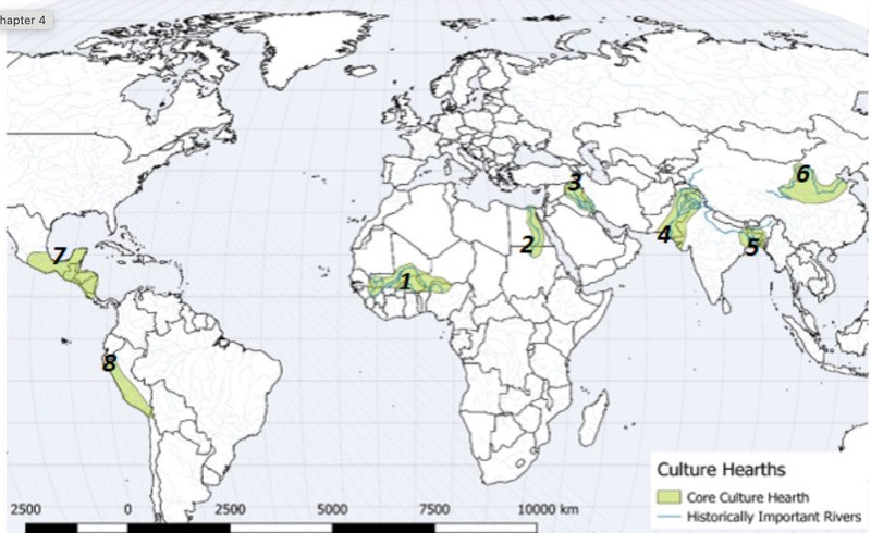
Urbanization developed independently in several major hearths, especially along major river valleys: Mesopotamia (Fertile Crescent), Nile River Valley (Egypt), Indus River Valley (South Asia), Huang He River Valley (China).
도시화는 여러 주요 발상지(hearths), 특히 큰 강 유역에서 독립적으로 발달했다. 메소포타미아(Mesopotamia, 비옥한 초승달 지대), 나일강 유역(이집트), 인더스강 유역(남아시아), 황허강 유역(중국)이다.
All of these regions shared: fertile soil, reliable water supply, favorable climate. Physical geography made large, dense populations possible. That is the foundation of urbanization.
이 모든 지역은 비옥한 토양, 믿을 만한 물 공급, 유리한 기후를 공통으로 가졌다. 자연지리가 크고 조밀한 인구를 가능하게 했으며, 이것이 도시화의 토대이다.
Urbanization Drivers: Historical Context 도시화 동인: 역사적 배경
First Agricultural Revolution: Agricultural surpluses freed up labor to establish the world's earliest cities as centers for trade, administration, and religion.
제1차 농업혁명(First Agricultural Revolution): 농업 잉여(agricultural surplus)가 노동력을 해방시켜, 무역·행정·종교의 중심지로서 세계 최초의 도시들이 세워졌다.
Industrial Revolution (18th-19th Centuries): Factory manufacturing created massive employment opportunities in cities. Simultaneously, the Second Agricultural Revolution mechanized farming, pushing rural labor into urban centers.
산업혁명(Industrial Revolution, 18~19세기): 공장 제조업이 도시에 대규모 일자리를 만들었다. 동시에 제2차 농업혁명(Second Agricultural Revolution)이 농업을 기계화하여 농촌 노동력을 도시 중심지로 밀어냈다.
Rural-to-Urban Migration 농촌에서 도시로의 이주
Rural-to-urban migration is the primary driver of rapid urbanization in Less Developed Countries (LDCs) today.
농촌-도시 이주(rural-to-urban migration)는 오늘날 개발도상국(LDCs, Less Developed Countries)에서 급속한 도시화를 일으키는 주된 동인이다.
| Factor 요인 | Examples 예 |
|---|---|
| Push factors (rural) 배출 요인(농촌) | Poverty, loss of agricultural jobs due to mechanization, environmental degradation, land scarcity, and armed conflict. 빈곤, 기계화로 인한 농업 일자리 상실, 환경 악화, 토지 부족, 무력 분쟁. |
| Pull factors (urban) 흡인 요인(도시) | Job opportunities in manufacturing and services, superior healthcare, higher education facilities, and perceived modern amenities. 제조업·서비스업 일자리, 더 나은 의료, 고등교육 시설, 현대적이라고 여겨지는 편의시설. |
Urban Population by Region 지역별 도시 인구 비율
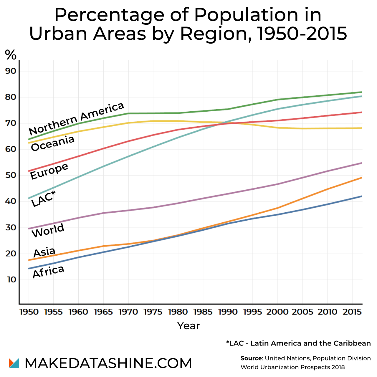
How to read it: the x-axis is the year (1950-2015) and the y-axis is the percentage of the population living in urban areas. A steeper line means faster urbanization.
읽는 법: 가로축은 연도(1950~2015), 세로축은 도시 지역에 사는 인구의 비율이다. 선이 가파를수록 도시화가 빠르다.
Key trends visible in the graph: every line is higher in 2015 than in 1950, although Oceania is flat in the later years; Northern America stays highest; LAC rises steeply; Africa and Asia stay below the World line and are the lowest.
그래프에서 보이는 핵심 추세: 모든 선이 1950년보다 2015년에 높다(다만 오세아니아는 후반부에 평평하다). 북미는 계속 가장 높고, LAC는 가파르게 상승하며, 아프리카와 아시아는 세계 선 아래에서 가장 낮다.
MDCs vs. LDCs Comparison MDC와 LDC 비교
| MDCs 선진국 | LDCs 개발도상국 | |
|---|---|---|
| Level of urbanization 도시화 수준 | High rate/percentage of urbanization (typically 75–80%+). 도시화의 비율(정도)이 높다(보통 75~80% 이상). | Lower overall percentage of urban residents. 전체 도시 거주자 비율이 더 낮다. |
| Speed of growth 성장 속도 | Rate of growth is currently slow or stagnant. 성장률은 현재 느리거나 정체 상태이다. | Speed/scale of urbanization is exceptionally high. 도시화의 속도와 규모가 매우 크다. |
| Result 결과 | – | Infrastructure cannot keep pace with this influx, leading to widespread informal settlements. 인프라가 이 유입을 따라가지 못해 비공식 정주지(informal settlements)가 널리 생긴다. |
⚠ The extracted slide text for this table is scrambled (columns interleaved). The slide image confirms the arrangement above, worded as on the slide: MDC = "High rate/percentage of urbanization (typically 75–80%+)", "Rate of growth is currently slow or stagnant"; LDC = "Lower overall percentage of urban residents", "Speed/scale of urbanization is exceptionally high".
⚠ 이 표의 슬라이드 추출 텍스트는 두 열의 글이 뒤섞여 있다. 슬라이드 이미지로 위의 배치를 확인했으며, 어구도 슬라이드 그대로다: MDC = "도시화 비율 높음(보통 75~80% 이상)", "성장률은 현재 느리거나 정체"; LDC = "전체 도시 거주자 비율이 더 낮음", "도시화의 속도·규모가 매우 큼".
Drivers of Urbanization (list) 도시화 동인 목록
- INDUSTRIALIZATION → factory jobs attract rural migrants
산업화(industrialization) → 공장 일자리가 농촌 이주민을 끌어들인다 - RURAL-TO-URBAN MIGRATION → education, healthcare, employment
농촌-도시 이주 → 교육, 의료, 고용 - POPULATION GROWTH
인구 증가 - TRANSPORTATION IMPROVEMENTS (railroads, ports, highways)
교통 개선(철도, 항만, 고속도로) - COMMUNICATION TECHNOLOGY
통신 기술 - ECONOMIC DEVELOPMENT
경제 발전 - GOVERNMENT POLICIES ENCOURAGING GROWTH
성장을 장려하는 정부 정책
Exam tip - MDC vs LDC: MDCs are already highly urbanized (typically 75-80%+) with slow or stagnant growth; LDCs have a lower percentage but exceptionally fast urbanization, and infrastructure cannot keep pace, so informal settlements spread. Push factors = rural reasons to leave; pull factors = urban reasons to come.
시험 팁 - MDC vs LDC: MDC는 이미 도시화율이 높고(보통 75~80% 이상) 성장이 느리거나 정체이다. LDC는 비율은 낮지만 도시화가 매우 빠르고 인프라가 따라가지 못해 비공식 정주지가 늘어난다. Push = 농촌을 떠나는 이유, Pull = 도시로 오는 이유.
Exam tip - Urbanization vs suburbanization vs sprawl: urbanization = a growing percentage of people live in cities; suburbanization = movement from cities to surrounding suburbs (see s12); urban sprawl = unrestricted, low-density expansion over rural land with minimal planning.
시험 팁 - 도시화 vs 교외화 vs 스프롤: 도시화 = 도시에 사는 인구 비율의 증가, 교외화 = 도시에서 주변 교외로의 이동(s12), 스프롤 = 최소한의 계획 아래 농촌 토지로 무제한·저밀도로 퍼지는 확장.
Suburbanization & Urban Sprawl 교외화와 도시 스프롤
Suburbanization 교외화
Suburbanization = movement from cities to surrounding suburbs.
교외화(suburbanization) = 도시에서 주변 교외(suburbs)로의 이동.
Major causes: automobile ownership; Interstate Highway Act of 1956 in the U.S.; larger homes; lower land costs; government mortgage policies and zoning.
주요 원인: 자동차 소유, 미국의 1956년 주간 고속도로법(Interstate Highway Act of 1956), 더 큰 주택, 더 낮은 토지 비용, 정부의 주택담보대출 정책과 용도지역제(zoning).
Pattern: urban core develops first → suburbs expand outward.
패턴: 도시 중심부가 먼저 발달한다 → 교외가 바깥으로 확장된다.
Consequences: erosion of the city center's tax base (urban decay) and increased socio-economic and racial segregation (white flight).
결과: 도심 세수 기반의 침식(도시 쇠퇴, urban decay)과 사회경제적·인종적 분리의 심화(백인 이탈, white flight).
⚠ The slide spells it "Erodence" of the city center's tax base; this is a typo for "erosion". It is written as erosion here.
⚠ 슬라이드에는 "Erodence"로 적혀 있으나 erosion(침식)의 오기이다. 여기서는 erosion으로 적었다.
Urban Sprawl: Definition 도시 스프롤: 정의
Urban sprawl: unrestricted, low-density expansion of housing, commercial strip malls, and roads over vast expanses of rural land with minimal centralized urban planning.
도시 스프롤(urban sprawl): 중앙집중적 도시계획이 거의 없는 상태에서 주택, 상업용 스트립 몰(strip malls), 도로가 광대한 농촌 토지 위로 제한 없이, 낮은 밀도로 퍼지는 확장.
Characteristics & Negative Impacts 특징과 부정적 영향
- Auto-Dependency: Infrastructure favors cars exclusively, making public transit inefficient or non-existent.
자동차 의존(auto-dependency): 인프라가 오로지 자동차에 유리하게 만들어져 대중교통이 비효율적이거나 아예 없다. - Loss of Prime Agricultural Land: Open space and fertile farmland on the urban fringe are permanently paved over.
우량 농지의 상실: 도시 외곽(urban fringe)의 열린 공간과 비옥한 농지가 영구적으로 포장된다. - High Infrastructure Costs: Extending water, power, roads, and emergency services over large, spread-out distances drains municipal budgets.
높은 인프라 비용: 물, 전력, 도로, 응급 서비스를 넓게 흩어진 거리 전체로 확장하면 지방자치단체 예산이 고갈된다.
Urban Sprawl: Mitigation Strategies 스프롤 완화 전략
Smart Growth & New Urbanism: planning movements designed to combat sprawl through mixed-use development, walkable communities, transit-oriented development (TOD), and urban growth boundaries (greenbelts).
스마트 성장(Smart Growth)과 신도시주의(New Urbanism): 복합용도 개발(mixed-use development), 걸어서 다닐 수 있는 공동체(walkable communities), 대중교통 중심 개발(transit-oriented development, TOD), 도시성장경계(urban growth boundaries, 그린벨트 greenbelts)를 통해 스프롤에 맞서도록 고안된 계획 운동.
| Strategy 전략 | Meaning on the slide 슬라이드상의 의미 |
|---|---|
| Mixed-use development 복합용도 개발 | Part of Smart Growth & New Urbanism planning against sprawl. 스프롤에 맞선 스마트 성장·신도시주의 계획의 한 수단. |
| Walkable communities 보행 가능 공동체 | Part of Smart Growth & New Urbanism planning against sprawl. 스프롤에 맞선 스마트 성장·신도시주의 계획의 한 수단. |
| Transit-oriented development (TOD) 대중교통 중심 개발 | Part of Smart Growth & New Urbanism planning against sprawl. 스프롤에 맞선 스마트 성장·신도시주의 계획의 한 수단. |
| Urban growth boundaries (greenbelts) 도시성장경계(그린벨트) | Part of Smart Growth & New Urbanism planning against sprawl. 스프롤에 맞선 스마트 성장·신도시주의 계획의 한 수단. |
Suburbanization vs. Urban Sprawl 교외화 vs 도시 스프롤 비교
| Suburbanization 교외화 | Urban sprawl 도시 스프롤 | |
|---|---|---|
| Definition 정의 | Movement from cities to surrounding suburbs. 도시에서 주변 교외로의 이동. | Unrestricted, low-density expansion of housing, strip malls and roads over vast rural land with minimal centralized planning. 중앙 계획이 거의 없이 주택·스트립 몰·도로가 광대한 농촌 토지로 제한 없이 저밀도로 확장. |
| Causes 원인 | Automobile ownership, Interstate Highway Act of 1956, larger homes, lower land costs, government mortgage policies and zoning. 자동차 소유, 1956년 주간 고속도로법, 큰 주택, 낮은 토지 비용, 정부 모기지 정책과 zoning. | (Slides list characteristics rather than causes.) (슬라이드는 원인이 아닌 특징을 제시한다.) |
| Consequences / impacts 결과·영향 | Erosion of the city center's tax base (urban decay); more socio-economic and racial segregation (white flight). 도심 세수 기반 침식(도시 쇠퇴); 사회경제적·인종적 분리 심화(백인 이탈). | Auto-dependency; loss of prime agricultural land; high infrastructure costs. 자동차 의존; 우량 농지 상실; 높은 인프라 비용. |
| Response 대응 | – | Smart Growth & New Urbanism: mixed-use, walkable, TOD, urban growth boundaries (greenbelts). 스마트 성장·신도시주의: 복합용도, 보행 가능, TOD, 도시성장경계(그린벨트). |
Essay tip (Urban sprawl, one of the 3 essay topics): (1) Define it: unrestricted, low-density expansion of housing, strip malls and roads over rural land with minimal centralized planning. (2) Give three negative impacts with a reason each: auto-dependency (transit inefficient or non-existent), loss of prime agricultural land (permanently paved over), high infrastructure costs (water, power, roads, emergency services over long distances drain municipal budgets). (3) Give mitigation: Smart Growth and New Urbanism using mixed-use development, walkable communities, TOD, and urban growth boundaries (greenbelts). Write complete sentences.
서술형 팁(도시 스프롤, 서술형 3주제 중 하나): (1) 정의: 중앙 계획이 거의 없이 주택·스트립 몰·도로가 농촌 토지로 제한 없이 저밀도로 확장. (2) 부정 영향 3가지와 각 이유: 자동차 의존(대중교통이 비효율적이거나 없음), 우량 농지 상실(영구 포장), 높은 인프라 비용(물·전력·도로·응급 서비스를 먼 거리로 확장하면 지자체 예산 고갈). (3) 완화: Smart Growth와 New Urbanism - 복합용도 개발, 보행 가능 공동체, TOD, 도시성장경계(그린벨트). 완전한 문장으로 쓴다.
Exam tip - suburbanization vs sprawl: suburbanization describes the movement of people from the city to the suburbs (with urban decay and white flight as consequences); sprawl describes the form of the expansion (unrestricted, low-density, minimally planned). Urban decay and white flight belong to suburbanization on the slides; auto-dependency, farmland loss and infrastructure costs belong to sprawl.
시험 팁 - 교외화 vs 스프롤: 교외화는 사람이 도시에서 교외로 이동하는 현상(결과: 도시 쇠퇴, 백인 이탈)이고, 스프롤은 확장의 형태(무제한, 저밀도, 최소한의 계획)이다. 슬라이드에서 도시 쇠퇴·백인 이탈은 교외화에, 자동차 의존·농지 상실·인프라 비용은 스프롤에 속한다.
Megacities & Metacities 메가시티와 메타시티
Classification 분류
| Classification 분류 | Population threshold 인구 기준 | Representative examples 대표 예 | Spatial issues 공간 문제 |
|---|---|---|---|
| Megacity 메가시티 | > 10 million 1,000만 명 초과 | Tokyo, Cairo, Mumbai, São Paulo, New York | Multiplied rapidly in the late 20th century. Megacities in LDCs suffer from severe infrastructure strain (housing shortages, pollution, traffic gridlock). 20세기 후반에 급속히 늘었다. LDC의 메가시티는 심각한 인프라 부담(주택 부족, 오염, 교통 정체)을 겪는다. |
| Metacity 메타시티 | > 20 million 2,000만 명 초과 | Guangzhou, Tokyo-Yokohama, Jakarta, Delhi, Seoul-Incheon | Result of continuous urban growth leading to vast conurbations and megalopolises. They form massive, interconnected regional networks of economic activity. 지속적인 도시 성장의 결과로 광대한 연담도시(conurbations)와 거대도시권(megalopolises)이 생긴다. 경제 활동의 거대하고 상호 연결된 지역 네트워크를 이룬다. |
Key Urban Challenges 주요 도시 과제
Squatter Settlements (Favelas / Bustees / Slums): In LDCs, self-built informal housing without legal tenure, clean water, sewage systems, or electricity.
무허가 정착지(squatter settlements; 파벨라 favelas / 부스티 bustees / 슬럼 slums): LDC에서 법적 보유권, 깨끗한 물, 하수 시설, 전기가 없는, 주민이 스스로 지은 비공식 주거.
Environmental Strain: Severe air pollution, urban heat island effects.
환경 부담: 심각한 대기 오염, 도시 열섬(urban heat island) 효과.
Governance Fragmented: Managing sprawling metacities requires cross-jurisdictional coordination that local municipal governments often lack.
분절된 거버넌스(governance): 넓게 퍼진 메타시티를 관리하려면 관할 구역을 넘나드는 조정이 필요한데, 지방 자치 정부에는 이것이 부족한 경우가 많다.
Growth of the Top 15 Megacities 상위 15개 메가시티의 성장
The map from Statista shows how much the 15 largest megacities in the world were predicted to grow between 2011 and 2025.
Statista의 지도는 세계 최대 메가시티 15곳이 2011년~2025년 사이에 얼마나 성장할 것으로 예측되었는지를 보여준다.
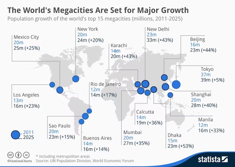
Reading tip: Tokyo is largest but grows slowest (+5%); Dhaka has the largest percentage growth (+53%) among the 15.
읽는 법: 도쿄는 가장 크지만 성장률은 가장 낮고(+5%), 15개 도시 중 다카가 성장률이 가장 높다(+53%).
Where Megacities Are 메가시티의 분포 변화
In the 1970s there were only eight megacities across the world: Tokyo, Osaka, Seoul, Moscow, New York, Los Angeles, Mexico City, and São Paulo - the majority of them were in HICs.
1970년대에는 세계에 메가시티가 단 8곳뿐이었다. 도쿄, 오사카, 서울, 모스크바, 뉴욕, 로스앤젤레스, 멕시코시티, 상파울루이며, 그중 대부분이 HIC(HICs)에 있었다.
Now megacities are mainly found in NEEs where urban population growth has been rapid. Around 80% of megacities are in Asia, particularly SE Asia, such as China, India, Bangladesh and Pakistan - the countries where the majority of our goods are manufactured so economic growth has seen people flock to cities for employment opportunities.
이제 메가시티는 도시 인구 증가가 빨랐던 NEE(NEEs)에 주로 있다. 메가시티의 약 80%가 아시아, 특히 중국·인도·방글라데시·파키스탄 같은 동남아시아 쪽에 있다. 이 나라들은 우리가 쓰는 물건 대부분을 만드는 곳이어서, 경제 성장으로 사람들이 일자리를 찾아 도시로 몰려들었다.
More recently we are starting to see them emerge in parts of Africa, such as Lagos in Nigeria and Cairo in Egypt.
최근에는 나이지리아의 라고스(Lagos), 이집트의 카이로(Cairo)처럼 아프리카 일부 지역에서도 메가시티가 나타나기 시작했다.
⚠ The slide writes "SE Asia, such as China, India, Bangladesh and Pakistan". This regional label looks like a slip on the slide ([보충] China is usually East Asia; India, Bangladesh and Pakistan South Asia). Learn the sentence as written, but do not use "SE Asia" as the basis for an answer about these countries.
⚠ 슬라이드는 "SE Asia(동남아시아), 예: 중국·인도·방글라데시·파키스탄"이라고 적었다. 이 지역 표기는 슬라이드의 오기로 보인다([보충] 중국은 보통 동아시아, 인도·방글라데시·파키스탄은 남아시아). 문장은 슬라이드대로 알아 두되, 이 나라들의 지역을 묻는 답의 근거로 "SE Asia"를 쓰지 말 것.
Megacities in Africa 아프리카의 메가시티
Africa currently has three megacities: Cairo (Egypt), Kinshasa (Democratic Republic of Congo) and Lagos (Nigeria), however this is expected to increase to 7 by 2050, with Dar es Salaam (Tanzania), Nairobi (Kenya), Khartoum (Sudan) and Luanda (Angola).
아프리카에는 현재 메가시티가 3곳(카이로[이집트], 킨샤사[콩고민주공화국], 라고스[나이지리아])이지만, 2050년까지 다르에스살람(탄자니아), 나이로비(케냐), 하르툼(수단), 루안다(앙골라)가 더해져 7곳으로 늘 것으로 예상된다.
Cairo is expected to have the biggest population with 32.6 million, followed by Kinshasa with 29 million and Lagos with 28.2 million. However, Dar es Salaam is expected to see the greatest population growth from 7.5 million today to 16.4 million by 2050 (+118%), and Nairobi's population is set to double from 5.2 million to 10.4 million.
카이로는 3,260만 명으로 인구가 가장 많고, 킨샤사 2,900만 명, 라고스 2,820만 명이 뒤따를 것으로 예상된다. 그러나 다르에스살람은 현재 750만 명에서 2050년 1,640만 명으로(+118%) 가장 큰 인구 증가를 보일 것으로 예상되고, 나이로비의 인구는 520만 명에서 1,040만 명으로 두 배가 될 전망이다.
⚠ The slide says Cairo will have "32.6 people"; this is a typo for 32.6 million (confirmed by the Statista graph on the next slide). Written as million here.
⚠ 슬라이드에는 카이로가 "32.6 people"로 적혀 있으나 32.6 million(백만)의 오기이다(다음 슬라이드의 Statista 그래프로 확인). 여기서는 million으로 적었다.
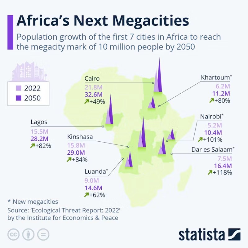
Future Megacities 미래의 메가시티
The Institute for Economics and Peace estimates that 70% of the global population will live in cities by 2050 (compared to 57% today), and that there will be another 14 megacities - with Delhi in the top spot, with a projected population of 49.6 million.
경제평화연구소(Institute for Economics and Peace)는 2050년까지 세계 인구의 70%가 도시에 살 것이며(현재는 57%), 메가시티가 14곳 더 생기고, 델리가 1위로 예상 인구 4,960만 명일 것이라고 추정한다.
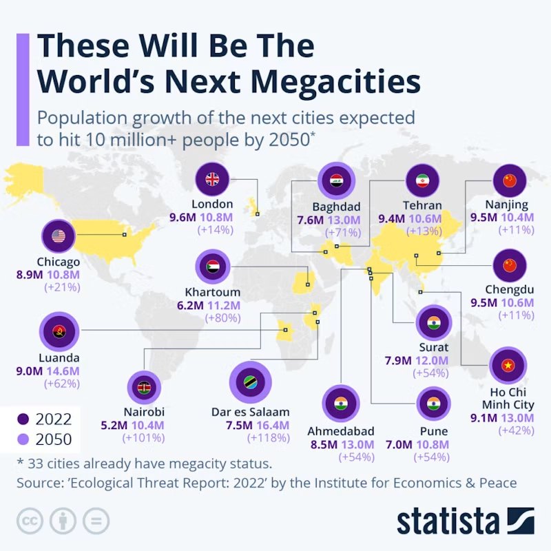
Pros and Cons of Megacities 메가시티의 장점과 문제점
Megacities are economic powerhouses that bring with them a huge range of services and job opportunities, as well as having huge labour markets and millions of potential customers. These factors encourage investment, both from local companies as well as foreign transnational corporations (TNCs), leading to a positive multiplier effect.
메가시티는 매우 다양한 서비스와 일자리를 제공하고, 거대한 노동 시장과 수백만의 잠재 고객을 가진 경제의 원동력이다. 이런 요인은 현지 기업과 외국의 초국적 기업(TNCs, transnational corporations) 모두의 투자를 끌어들여 긍정적인 승수 효과(multiplier effect)를 낳는다.
However, rapid urbanisation can also mean that the infrastructure and services of megacities can struggle to cope with their huge populations, making life challenging for residents. It can also lead to the emergence of informal settlements. LIC/NEE cities can also have high levels of air and water pollution, along with traffic congestion.
그러나 급속한 도시화는 메가시티의 인프라와 서비스가 거대한 인구를 감당하기 힘들게 하여 주민의 삶을 어렵게 만들 수 있다. 또한 비공식 정주지(informal settlements)의 출현으로 이어질 수 있다. LIC/NEE의 도시는 대기·수질 오염과 교통 혼잡도 심할 수 있다.
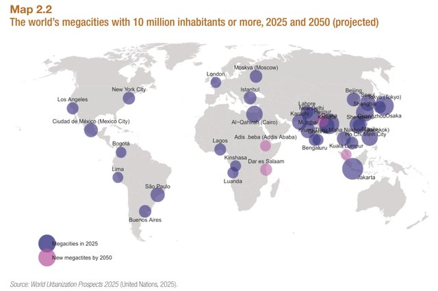
Metacities and Top-Tier World Cities, 2020 메타시티와 최상위 세계도시(2020)
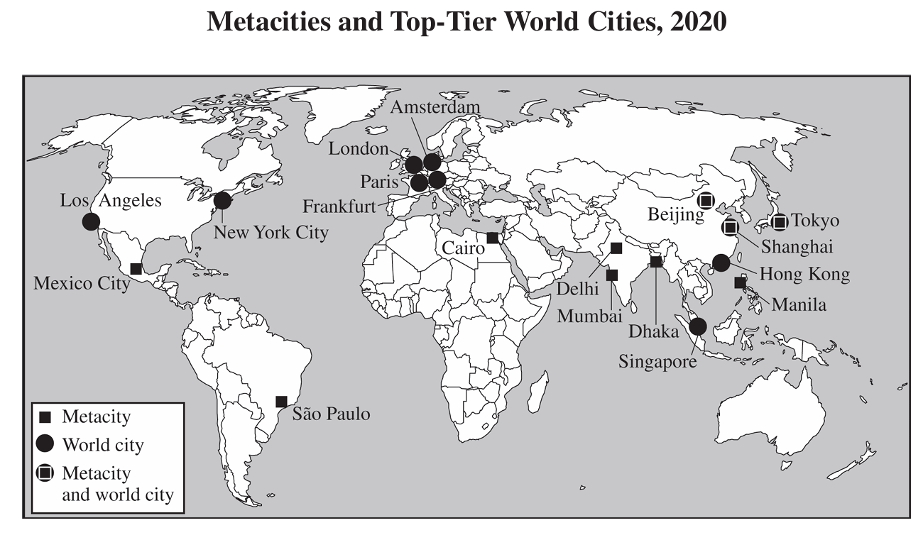
Selected Cities (estimates) 선별 도시(추정치)
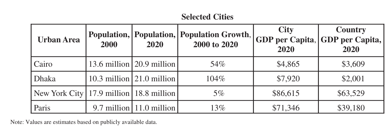
| City 도시 | Pop. 2000 | Pop. 2020 | Growth 성장률 | City GDP/capita 도시 1인당 GDP | Country GDP/capita 국가 1인당 GDP |
|---|---|---|---|---|---|
| Cairo 카이로 | 13.6M | 20.9M | 54% | $4,865 | $3,609 |
| Dhaka 다카 | 10.3M | 21.0M | 104% | $7,920 | $2,001 |
| New York City 뉴욕시 | 17.9M | 18.8M | 5% | $86,615 | $63,529 |
| Paris 파리 | 9.7M | 11.0M | 13% | $71,346 | $39,180 |
Reading the table: Cairo and Dhaka grew by 54% and 104% between 2000 and 2020, while New York City and Paris grew by 5% and 13%. In all four cities, the city GDP per capita is higher than the country GDP per capita.
표 읽기: 카이로와 다카는 2000~2020년에 54%, 104% 성장했고, 뉴욕시와 파리는 5%, 13% 성장했다. 네 도시 모두 도시 1인당 GDP가 국가 1인당 GDP보다 높다.
Exam tip - megacity vs metacity: megacity = more than 10 million people; metacity = more than 20 million (Tokyo-Yokohama, Delhi, Jakarta, Guangzhou, Seoul-Incheon on the slide). Tokyo, Cairo, Mumbai, Sao Paulo and New York are the megacity examples. Metacities are linked to conurbations and megalopolises and regional networks of economic activity.
시험 팁 - 메가시티 vs 메타시티: 메가시티 = 1,000만 명 초과, 메타시티 = 2,000만 명 초과(슬라이드의 예: 도쿄-요코하마, 델리, 자카르타, 광저우, 서울-인천). 도쿄·카이로·뭄바이·상파울루·뉴욕이 메가시티의 예이다. 메타시티는 연담도시·거대도시권, 경제 활동의 지역 네트워크와 연결된다.
Exam tip - trend: in the 1970s there were eight megacities, mostly in HICs; now about 80% are in Asia (NEEs), and Africa is expected to go from 3 to 7 megacities by 2050. Globally, 70% of people are expected to live in cities by 2050 (57% today).
시험 팁 - 추세: 1970년대 메가시티는 8곳이고 대부분 HIC에 있었다. 지금은 약 80%가 아시아(NEE)에 있고, 아프리카는 2050년까지 3곳에서 7곳으로 늘 전망이다. 세계적으로 2050년에는 인구의 70%가 도시에 살 전망이다(현재 57%).
Bid-rent Theory & the Burgess Concentric Zone Model 입찰지대 이론과 버제스 동심원 모델
⚠ Essay topic: the Concentric (Burgess) zone model is one of the three written-exam topics. Learn the five zones in order, their features, and the three criticisms (s15).
⚠ 서술형 출제 주제: 동심원(버제스) 모델(Concentric zone model)은 서술형 3주제 중 하나다. 5개 구역의 순서·특징과 3가지 비판(s15)을 반드시 익힐 것.
1. Bid-rent theory (William Alonso) 입찰지대 이론 (윌리엄 알론소)
Slide topics: "Bid-rent theory (William Alonso)" and "Urban land use theories". The slides show bid-rent theory (U6b p3), then a section title "Urban land use theories" (U6b p4), then the Burgess concentric zone model (U6b p5).
슬라이드 주제: "입찰지대 이론(Bid-rent theory, 윌리엄 알론소)"과 "도시 토지이용 이론(Urban land use theories)". 슬라이드는 입찰지대 이론(U6b p3) → 단원 제목 "도시 토지이용 이론"(U6b p4) → 버제스 동심원 모델(Burgess concentric zone model, U6b p5) 순서로 나온다.
How to read the graph (F27): the vertical axis is rent per m2; the horizontal axis is distance from the CBD. The Retail line is the steepest, so retail bids the highest rent at the CBD but loses value fastest with distance. The Manufacturing line is in the middle. The Residential line is the flattest. Below the graph, the land-use bands are concentric: retail (pink) at the center, manufacturing (cyan) around it, and residential (orange) in the outer area.
그래프 읽는 법(F27): 세로축은 m2당 임대료(rent per m2), 가로축은 CBD로부터의 거리(distance from CBD)다. 소매업(Retail) 선이 가장 가파르므로 CBD에서 가장 높은 지대를 제시하지만 거리가 멀어질수록 가장 빨리 낮아진다. 제조업(Manufacturing) 선은 중간이고, 주거(Residential) 선이 가장 완만하다. 그래프 아래의 토지이용 띠는 동심원이다: 중심에 소매(분홍), 그 바깥에 제조업(하늘색), 가장 바깥에 주거(주황).
| Land use 토지이용 | Slope of line (F27) 선의 기울기 | Rent at the CBD CBD에서의 지대 | Band location 띠의 위치 |
|---|---|---|---|
| Retail 소매업 | Steepest 가장 가파름 | Highest 가장 높음 | Center (pink) 중심(분홍) |
| Manufacturing 제조업 | Middle 중간 | Middle 중간 | Around the center (cyan) 중심 바깥(하늘색) |
| Residential 주거 | Flattest 가장 완만함 | Lowest 가장 낮음 | Outer area (orange) 바깥쪽(주황) |
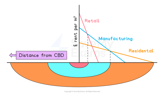
[보충] Each land use occupies the zone where its line lies above the others, so steeper lines win near the center. (Reading aid only; not stated on the slide.)
[보충] 각 토지이용은 자신의 선이 다른 선보다 위에 있는 구간을 차지하므로, 가파른 선이 중심 가까이에서 이긴다. (그래프 읽기 보조 설명이며 슬라이드 문장은 아님.)
2. Burgess Concentric Zone Theory (1925) 버제스 동심원 지대 이론 (1925)
The Concentric Zone model depicts the US city of 1900–1950, expanding rapidly as people move away from inner-city locations toward places with a higher standard of living.
동심원 지대 모델(Concentric Zone model)은 1900–1950년 미국 도시(US city)를 나타내며, 사람들이 도심 인근 지역(inner-city)에서 더 높은 생활수준(standard of living)을 누릴 수 있는 곳으로 이동함에 따라 도시가 빠르게 팽창하는 모습을 보여 준다.
The model is based on the idea that mobility, the number of people who pass by a location, is a prime determinant of land valuing, meaning (pre-automobile) that downtowns are the most valuable.
이 모델은 이동성(mobility, 어떤 장소를 지나가는 사람의 수)이 토지 가치 평가(land valuing)의 주된 결정 요인이라는 생각에 근거한다. 즉 (자동차 이전 시대에는) 다운타운(downtown)이 가장 가치가 높다는 뜻이다.
The model significantly influenced US urban geography and other models that expanded upon it.
이 모델은 미국 도시지리학과, 이를 확장한 다른 모델들에 큰 영향을 주었다.
3. The five zones 5개 구역
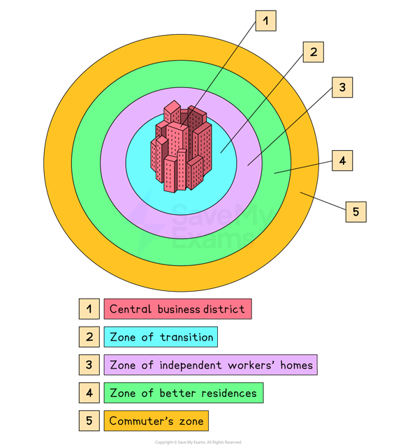
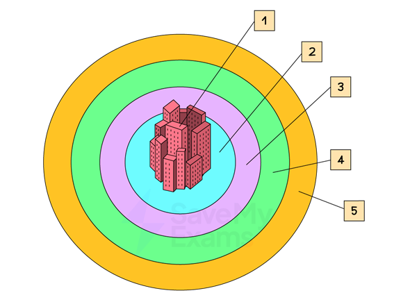
| # 번호 | Zone (F28) 구역 | Key features 핵심 특징 | Example 대표 예 |
|---|---|---|---|
| 1 | Central Business District (CBD) 중심업무지구 (북미: downtown) | Commercial center; peak land value intersection (PLVI); high density and vertical growth (skyscrapers); commercial and economic hub; focus of transportation networks; high daytime vs. low nighttime population. 도시의 상업 중심; 최고 지가 교차점(PLVI); 고밀도·수직 성장(고층건물); 상업·경제 허브; 교통망의 중심; 낮 인구는 많고 밤 인구는 적음. | Chicago Loop; Downtown LA 시카고 루프; 로스앤젤레스 다운타운 |
| 2 | Zone of transition (Zone in Transition) 전이지대 | Mixed land use (residences among factories); very low housing values; tenements; lower-class citizens and new immigrants; high-density slums; invasion and succession as the CBD expands. 혼합 토지이용(주거지와 공장이 섞임); 매우 낮은 주택 가치; 공동주택(tenement); 하층민·신규 이민자; 고밀도 슬럼; CBD 팽창에 따른 침입과 계승. | Chicago tenements / slum 1920s; meatpacking district (U6b p13). LA: Chinatown and Little Italy are called "inner-city ethnic enclaves" on U6b p17 (no zone number given). 1920년대 시카고 공동주택·슬럼; 육가공 지구(U6b p13). LA의 차이나타운·리틀 이탈리아는 U6b p17에서 "도심 인근 민족 집단 거주지(inner-city ethnic enclaves)"라고만 하고 구역 번호는 붙이지 않음. |
| 3 | Zone of independent workers' homes (Working-class residential zone, inner suburbs) 독립 노동자 주거지대 (노동자 계층 주거지대, 내부 교외) | Where most of the working class employed in the CBD live; close to the CBD because historically they could not afford to commute to work there. CBD에서 일하는 노동자 계층 대부분이 사는 곳; 역사적으로 CBD까지 통근할 여력이 없어서 CBD 가까이에 산다. | – 슬라이드에 예 없음 |
| 4 | Zone of better residences (Middle-class residential zone, outer suburbs) 더 나은 주거지대 (중산층 주거지대, 외부 교외) | Better and more expensive housing for those who can afford it; far enough from the CBD to be a relatively newer region with newer buildings and better amenities. 여유 있는 사람들을 위한 더 좋고 비싼 주택; CBD에서 충분히 떨어져 있어 비교적 새로운 지역이며 건물이 새롭고 편의시설이 더 좋다. | – 슬라이드에 예 없음 |
| 5 | Commuter's zone (Upper-class residential zone, outskirts of outer suburbs; "uptown") 통근자 지대 (상류층 주거지대, 외부 교외의 외곽; "업타운") | Typically the richest part of the urban agglomeration; spacious, spread-out housing; residents can afford to commute to the CBD in private vehicles (a luxury in the early 20th century); called uptown in North America. 대개 도시 집적지에서 가장 부유한 지역; 넓고 띄엄띄엄 있는 주택; 주민이 자가용으로 CBD에 통근할 수 있다(20세기 초에는 사치); 북미에서는 uptown이라 부른다. | Beverly Hills, Malibu (LA) (LA의) 베벌리힐스, 말리부 |
⚠ Zone name ↔ class name (zones 3·4·5): the slide headers on U6b p14–16 show the zone number and name ("3 Zone of independent workers' homes", "4 Zone of better residences", "5 Commuter's zone") above the Working-, Middle- and Upper-Class Residential Zone text. So this match is confirmed by the slides, not an editorial guess. (The headers are images, so they are not in the extracted slide text.)
⚠ 구역 이름 ↔ 계층 이름 대응(3·4·5구역): U6b p14–16 슬라이드 머리글에 구역 번호와 이름("3 독립 노동자 주거지대", "4 더 나은 주거지대", "5 통근자 지대")이 표기되어 있고, 그 아래 본문이 각각 노동자 계층·중산층·상류층 주거지대다. 따라서 이 대응은 편집 판단이 아니라 슬라이드에서 확인된 것이다. (머리글은 이미지라 추출된 슬라이드 텍스트에는 없다.)
Zone 1: Central Business District (CBD) 1구역: 중심업무지구
Central Business District (CBD): The commercial center of the city and contains the peak land value intersection, the area with the greatest land value and commercial value. In North America, this region is typically called downtown.
중심업무지구(Central Business District, CBD): 도시의 상업 중심지로, 최고 지가 교차점(peak land value intersection)을 포함한다. 이곳은 토지 가치와 상업적 가치가 가장 큰 지역이다. 북미에서는 이 지역을 보통 다운타운(downtown)이라고 부른다.
Peak Land Value Intersection (PLVI): The CBD contains the most expensive land in the city due to high demand and central accessibility.
최고 지가 교차점(PLVI): 높은 수요와 중심의 접근성(central accessibility) 때문에 CBD에는 도시에서 가장 비싼 땅이 있다.
High Density and Vertical Growth: High land costs lead to intensive land use, resulting in a high concentration of skyscrapers and multi-story commercial buildings to maximize space.
고밀도와 수직 성장(High Density and Vertical Growth): 높은 땅값이 집약적 토지이용(intensive land use)을 낳아, 공간을 최대로 활용하려는 고층건물(skyscraper)과 다층 상업건물이 고도로 집중된다.
Commercial & Economic Hub: Concentration of financial institutions, corporate headquarters, retail centers, professional services (law, consulting), and government offices. Low residential population density compared to commercial office spaces.
상업·경제 허브(Commercial & Economic Hub): 금융기관, 기업 본사, 소매 중심지, 전문 서비스(법률·컨설팅), 정부 기관이 집중한다. 상업용 사무 공간에 비해 거주 인구 밀도는 낮다.
Focus of Transportation Networks: Major roads, highways, subway lines, and bus routes converge here, making it the most accessible point in the metropolitan area.
교통망의 중심(Focus of Transportation Networks): 주요 도로, 고속도로, 지하철 노선, 버스 노선이 이곳으로 모여, 대도시권(metropolitan area)에서 접근성이 가장 좋은 지점이다.
High Daytime vs. Nighttime Population: Experiences a massive influx of commuters during daytime business hours and a sharp decline in population during evenings and weekends.
낮 인구 대 밤 인구(High Daytime vs. Nighttime Population): 낮 업무 시간에는 통근자가 대거 유입되고, 저녁과 주말에는 인구가 급감한다.
The Loop skyline as seen from Lake Michigan (photo slide): Chicago City Hall, financial institutions, large corporate headquarters, and big law firms are concentrated here.
미시간 호에서 본 루프(Loop) 스카이라인(사진 쪽): 시카고 시청, 금융기관, 대기업 본사, 대형 로펌 등이 밀집해 있다.
Zones 3–5: the residential zones 3~5구역: 주거지대
The Working Class Residential Zone (Inner Suburbs): This is the zone where most of the working class employed in the central business district live. Its proximity to the CBD makes it convenient to the working classes, as historically, they did not possess the means to commute to the CBD for work.
노동자 계층 주거지대(내부 교외, Inner Suburbs): CBD에서 일하는 노동자 계층 대부분이 사는 구역이다. CBD와 가깝기 때문에 노동자 계층에게 편리한데, 역사적으로 이들은 CBD로 일하러 통근할 수단이 없었기 때문이다.
The Middle-Class Residential Zone or the Outer Suburbs: This region provides better and more expensive housing to those who can afford it. It is typically far enough away from the CBD for it to be a relatively newer region with newer buildings and better amenities.
중산층 주거지대 또는 외부 교외(Outer Suburbs): 여유가 되는 사람들에게 더 좋고 더 비싼 주택을 제공하는 지역이다. 대개 CBD에서 충분히 멀어 비교적 새로운 지역이며, 건물이 더 새롭고 편의시설(amenity)이 더 좋다.
The Upper-Class Residential Zone or the Outskirts of Outer Suburbs: This is typically the richest part of the urban agglomeration. Housing here is spacious and spread out, and the residents can afford to commute to the CBD in their own private vehicles. This was a luxury in the early 20th century when the model was first devised. This region is typically called uptown in North America.
상류층 주거지대 또는 외부 교외의 외곽(Outskirts of Outer Suburbs): 대개 도시 집적지(urban agglomeration)에서 가장 부유한 지역이다. 이곳의 주택은 넓고 띄엄띄엄 떨어져 있으며, 주민들은 자가용으로 CBD에 통근할 여유가 있다. 이는 모델이 처음 고안된 20세기 초에는 사치였다. 북미에서는 이 지역을 보통 업타운(uptown)이라 부른다.
⚠ The slides give five zones in text and in F28/F32. The Chicago 1920s diagram (F29) uses a six-item legend (I Loop · II Factory zone · III Zone of transition · IV Working class zone · V Residential zone · VI Commuter zone). For zone-number questions use the five-zone version (F28/F32).
⚠ 슬라이드 본문과 F28/F32는 5구역이다. 시카고 1920년대 그림(F29)은 6개 항목 범례(I 루프 · II 공장 지대 · III 전이지대 · IV 노동자 지대 · V 주거 지대 · VI 통근 지대)를 쓴다. 구역 번호 문제는 5구역(F28/F32)을 기준으로 한다.
4. Chicago example (F29) 시카고 사례 (F29)
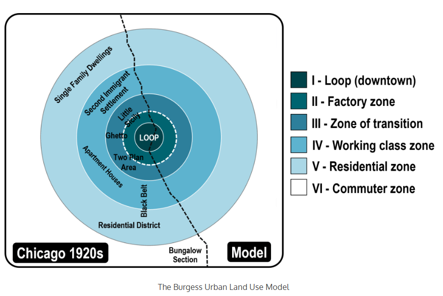
The Chicago Loop is the oldest part of Chicago, home to its central business district, and the heart of downtown Chicago. 40% of all Chicago residents work here.
시카고 루프(Chicago Loop)는 시카고에서 가장 오래된 지역으로, 중심업무지구가 있는 시카고 다운타운의 심장부다. 시카고 전체 주민의 40%가 이곳에서 일한다.
Downtown LA served as the CBD, around which the city expanded in a circular pattern. Early low-wage immigrants settled in inner-city ethnic enclaves like Chinatown and Little Italy, driving outward spatial growth as predicted by the Concentric Zone Model. Today, high-income neighborhoods like Beverly Hills and Malibu occupy the outermost ring, furthest from the CBD.
로스앤젤레스 다운타운(Downtown LA)이 CBD 역할을 했고, 도시는 그 주위로 원형으로 확장되었다. 초기 저임금 이민자들은 차이나타운과 리틀 이탈리아 같은 도심 인근의 민족 집단 거주지(ethnic enclave)에 정착했고, 이는 동심원 모델이 예측한 대로 바깥쪽으로의 공간적 성장을 이끌었다. 오늘날 베벌리힐스와 말리부 같은 고소득 지역이 CBD에서 가장 먼 가장 바깥 고리를 차지한다.
Essay checklist — Burgess concentric zone model. (1) Name: Concentric Zone model, Burgess, 1925. (2) Assumption: US city of 1900–1950; mobility (people passing by) determines land value; pre-automobile, downtown is most valuable. (3) Five zones in order from the center: 1 CBD → 2 Zone of transition → 3 Zone of independent workers' homes (inner suburbs) → 4 Zone of better residences (middle class, outer suburbs) → 5 Commuter's zone (upper class, uptown). (4) CBD keywords: PLVI, high density, vertical growth/skyscrapers, transportation hub, high daytime vs. low nighttime population. (5) Zone of transition: mixed land use, tenements, slums, new immigrants, invasion and succession. (6) Moving outward from the CBD, residents become wealthier and housing is newer and more spacious; the outer zone commutes by private vehicle. (7) Examples: Chicago Loop (40% of residents work there), Downtown LA (Chinatown, Little Italy; Beverly Hills, Malibu). (8) Criticisms: America-centric; no geographic limits (Tokyo/Mount Fuji); no gentrification.
서술형 체크리스트 — 버제스 동심원 모델. (1) 이름: 동심원 지대 모델, 버제스, 1925. (2) 가정: 1900–1950년 미국 도시; 이동성(지나가는 사람 수)이 지가를 결정; 자동차 이전에는 다운타운이 가장 가치가 높음. (3) 중심에서 바깥으로 5구역 순서: 1 CBD → 2 전이지대 → 3 독립 노동자 주거지대(내부 교외) → 4 더 나은 주거지대(중산층, 외부 교외) → 5 통근자 지대(상류층, 업타운). (4) CBD 키워드: PLVI, 고밀도, 수직 성장/고층건물, 교통 중심, 낮 인구 많고 밤 인구 적음. (5) 전이지대: 혼합 토지이용, 공동주택, 슬럼, 신규 이민자, 침입과 계승. (6) CBD에서 바깥으로 갈수록 주민이 더 부유하고 주택이 더 새롭고 넓어지며, 바깥 구역은 자가용으로 통근. (7) 예: 시카고 루프(주민 40%가 근무), LA 다운타운(차이나타운·리틀 이탈리아; 베벌리힐스·말리부). (8) 비판: 미국 중심적; 지형적 확장 한계 무시(도쿄/후지산); 젠트리피케이션 미반영.
Zone of Transition, Filtering, Gentrification & Criticisms 전이지대·여과·젠트리피케이션·비판
1. The Zone of transition 전이지대(Zone of transition)
Photo slides: 1920s Chicago tenements / slum and Meatpacking District (past) → West Loop / Fulton Market (today, gentrified; see §4).
사진 쪽: 1920년대 시카고 공동주택(tenement)·슬럼(slum)과 육가공 지구(Meatpacking District)(과거) → 웨스트 루프/풀턴 마켓(현재, 젠트리피케이션; §4 참조).
Mixed Land Use: Residences are intermixed with industrial zones and factories.
혼합 토지이용(Mixed Land Use): 주거지가 공업 지대·공장과 뒤섞여 있다.
Housing Conditions & Value: Due to noise and pollution from nearby industrial zones, housing values are very low.
주거 여건과 가치: 인근 공업 지대의 소음과 오염 때문에 주택 가치가 매우 낮다.
Most residences are apartments, many of which are tenements—rundown apartment buildings minimally maintained by landlords.
대부분의 주거지는 아파트이며, 그중 다수가 공동주택(tenement), 즉 집주인이 최소한만 관리하는 낡은 아파트 건물이다.
Demographics: Primarily inhabited by lower-class citizens and new immigrants to the city.
인구 구성: 주로 하층민과 도시로 새로 들어온 이민자가 거주한다.
Slum Area: Forms high-density slums characterized by substandard housing.
슬럼 지역: 기준 미달 주택(substandard housing)이 특징인 고밀도 슬럼(slum)을 이룬다.
Invasion and Succession: As the CBD continuously expands, it pushes into the Zone in Transition, causing the surrounding zones to continually push outwards and rebuild their infrastructures.
침입과 계승(Invasion and Succession): CBD가 계속 팽창하면서 전이지대로 밀고 들어가, 주변 구역들이 계속 바깥으로 밀려나며 기반시설(infrastructure)을 다시 짓게 된다.
2. Invasion, Competition, Succession 침입 → 경쟁 → 계승
Invasion: A new or incoming group (often newer, poorer immigrants or a different socioeconomic group) enters an established area.
침입(Invasion): 새로 들어오는 집단(흔히 더 새로 온 가난한 이민자나 다른 사회경제적 집단)이 이미 자리 잡은 지역으로 들어온다.
Competition: Groups struggle for limited land, housing, and jobs.
경쟁(Competition): 집단들이 한정된 토지·주택·일자리를 두고 다툰다.
Succession: The incoming group completely replaces the previous group, altering the cultural, ethnic, or socioeconomic character of that neighborhood.
계승(Succession): 들어온 집단이 이전 집단을 완전히 대체하여, 그 동네의 문화적·민족적·사회경제적 성격을 바꾼다.
e.g., the meatpacking zone and other industrial areas formed a ring around the downtown, and beyond that, they were expanding into the slums where people from all over the world formed ethnic enclaves: Greeks, Belgians, Chinese, Jews. One such area was where African Americans from Mississippi, part of the Great Migration out of the Jim Crow South, resided.
예) 육가공 지대와 다른 공업 지역이 다운타운 둘레에 고리를 이루었고, 그 바깥에서는 슬럼으로 확장해 들어갔는데, 이곳에서 전 세계에서 온 사람들이 민족 집단 거주지(ethnic enclave)를 이루었다: 그리스인, 벨기에인, 중국인, 유대인. 그런 지역 중 하나에는 짐 크로(Jim Crow) 남부를 떠난 대이주(Great Migration)의 일부로 미시시피에서 온 아프리카계 미국인이 살았다.
| Step 단계 | What happens 내용 |
|---|---|
| 1. Invasion 1. 침입 | A new or incoming group enters an established area. 새 집단이 기존 지역으로 들어옴. |
| 2. Competition 2. 경쟁 | Groups struggle for limited land, housing, and jobs. 한정된 토지·주택·일자리를 두고 다툼. |
| 3. Succession 3. 계승 | The incoming group completely replaces the previous group. 들어온 집단이 이전 집단을 완전히 대체함. |
Do not mix up the terms: invasion = a new group enters; succession = the new group replaces the old one.
용어 혼동 주의: 침입 = 새 집단이 들어옴; 계승 = 새 집단이 기존 집단을 대체함.
3. The Filtering process 여과 과정(Filtering Process)
The Filtering Process (Economic/Physical), or Filtering Down, is an economic and spatial mechanism that explains how housing passes from higher-income groups to lower-income groups over time as the physical structures age.
여과 과정(Filtering Process, 경제적·물리적), 즉 하향 여과(Filtering Down)는 건물이 낡아 감에 따라 주택이 시간이 지나면서 고소득 집단에서 저소득 집단으로 넘어가는 과정을 설명하는 경제적·공간적 메커니즘이다.
| Stage 단계 | Name 이름 | What happens 내용 |
|---|---|---|
| 1 | Suburbanization & New Construction 교외화와 신축 | High-income households purchase or build new homes in outer suburban zones. 고소득 가구가 바깥 교외 지역에 새 집을 사거나 짓는다. |
| 2 | Deterioration & Value Decline 노후화와 가치 하락 | Inner-city homes age and lose market value; the original wealthy owners move out, leaving vacant housing behind. 도심 주택이 낡고 시장 가치를 잃으며, 원래의 부유한 소유자가 떠나 빈 주택이 남는다. |
| 3 | Filtering Down 하향 여과 | Middle-income, and eventually lower-income, households move into these older homes as rental prices drop. 임대료가 떨어지면서 중간 소득, 결국에는 저소득 가구가 이 낡은 집으로 들어온다. |
| 4 | Subdivision & Repurposing 분할과 용도 변경 | Landlords divide large single-family homes into multi-family apartments or low-rent single rooms to maximize rental yield. 집주인이 임대 수익을 극대화하려고 큰 단독주택을 다가구 아파트나 저렴한 단칸방으로 나눈다. |
| 5 | Abandonment or Slum Formation 방치 또는 슬럼 형성 | When maintenance costs exceed rental revenue, properties deteriorate further, leading to structural abandonment and the formation of slums in the Zone of Transition. 유지비가 임대 수입을 넘으면 건물이 더 악화되어 구조적 방치와 전이지대의 슬럼 형성으로 이어진다. |
Order to memorize: Suburbanization & New Construction → Deterioration & Value Decline → Filtering Down → Subdivision & Repurposing → Abandonment or Slum Formation.
5단계 순서 암기: 교외화·신축 → 노후화·가치 하락 → 하향 여과 → 분할·용도 변경 → 방치·슬럼 형성.
4. Filtering Up = Gentrification 상향 여과 = 젠트리피케이션
The slide has two parts. Before (1920s): Slum 1920s; Chicago Tenements; Meatpacking District. Today: West Loop / Fulton Market — "Gentrification & Urban Revitalization: *Filtering Up! Gentrification!" So the 1920s slum, tenement and meatpacking areas are the past state, and West Loop / Fulton Market is the gentrified, revitalized present (filtering up).
슬라이드는 두 부분으로 되어 있다. 과거(1920년대): 1920년대 슬럼; 시카고 공동주택; 육가공 지구(Meatpacking District). 현재: 웨스트 루프/풀턴 마켓 — "젠트리피케이션과 도시 재활성화(Gentrification & Urban Revitalization): 상향 여과(Filtering Up)! 젠트리피케이션(Gentrification)!" 즉 1920년대 슬럼·공동주택·육가공 지구는 과거 상태이고, 웨스트 루프/풀턴 마켓이 젠트리피케이션으로 재활성화된 현재(상향 여과)다.
| Term 용어 | Direction 방향 |
|---|---|
| Filtering Down (Filtering Process) 하향 여과 | Housing passes from higher-income to lower-income groups as buildings age. 건물이 낡으면서 주택이 고소득 집단에서 저소득 집단으로 넘어감. |
| Filtering Up = Gentrification 상향 여과 = 젠트리피케이션 | Former 1920s slum/tenement/meatpacking areas are revitalized today (e.g., West Loop / Fulton Market). 1920년대 슬럼·공동주택·육가공 지역이 오늘날 재활성화됨(예: 웨스트 루프/풀턴 마켓). |
5. Criticisms of the Concentric Zone Model 동심원 모델에 대한 비판
America Centric: lack of applicability outside North America. While North American cities feature poorer populations in the CBD and wealth in the outer suburbs, cities in Europe and Asia were historically built around central fortresses or palaces, keeping the wealthiest residents concentrated in the city center rather than on the periphery.
미국 중심적(America Centric): 북미 밖에서는 적용하기 어렵다. 북미 도시는 CBD에 더 가난한 인구가, 외부 교외에 부가 있는 반면, 유럽과 아시아의 도시는 역사적으로 중앙의 요새나 궁전을 중심으로 만들어져 가장 부유한 주민이 외곽이 아니라 도시 중심에 모여 있었다.
Does Not Account for Geographical Limits to Expansion: The Concentric Zone Model assumes an isotropic plane with no physical barriers to urban expansion. In reality, physical geographic features like mountains, seas, or deserts limit outward growth—as seen in Tokyo, where mountains like Mount Fuji restrict expansion to the west, preventing the city from expanding in a uniform concentric pattern.
확장의 지리적 한계를 고려하지 않음: 동심원 모델은 도시 확장을 막는 물리적 장벽이 없는 등방성 평면(isotropic plane)을 가정한다. 현실에서는 산·바다·사막 같은 지형이 바깥으로의 성장을 제한한다. 도쿄에서는 후지산 같은 산이 서쪽 확장을 막아, 도시가 균일한 동심원 형태로 확장하지 못한다.
Does Not Account for Gentrification: Gentrification is the process by which a formerly low-income, "downtown" neighborhood changes character and comes to be coveted by wealthier inhabitants as the preferred destination for opening businesses and for residing. Gentrification overtakes the "working-class residential zone" and forces working-class people further into poverty and dislocates them from their homes. The concentric zone model fails to take into account the manner in which such gentrification processes defy the patterns of expansion predicted by it.
젠트리피케이션을 고려하지 않음: 젠트리피케이션(gentrification)은 예전에 저소득이던 "다운타운" 동네가 성격이 바뀌어, 사업체를 열고 거주하기에 선호되는 곳으로 더 부유한 주민들이 탐내게 되는 과정이다. 젠트리피케이션은 "노동자 계층 주거지대"를 덮치며, 노동자 계층을 더 깊은 빈곤으로 몰아넣고 집에서 내쫓는다. 동심원 모델은 이런 젠트리피케이션 과정이 모델이 예측한 확장 패턴을 거스른다는 점을 고려하지 못한다.
| Criticism 비판 | Why the model fails 모델이 맞지 않는 이유 | Example 예 |
|---|---|---|
| 1. America-centric 1. 미국 중심적 | Not applicable outside North America: in Europe and Asia the wealthiest stayed in the center. 북미 밖에서는 적용 불가: 유럽·아시아에서는 가장 부유한 주민이 중심에 머묾. | Cities built around central fortresses or palaces 중앙의 요새·궁전을 중심으로 만든 도시 |
| 2. Geographic limits to expansion 2. 확장의 지리적 한계 | Assumes an isotropic plane with no barriers; mountains, seas, deserts limit growth. 장벽 없는 등방성 평면을 가정; 산·바다·사막이 성장을 제한함. | Tokyo: Mount Fuji restricts expansion to the west 도쿄: 후지산이 서쪽 확장을 막음 |
| 3. Does not account for gentrification 3. 젠트리피케이션 미반영 | Gentrification overtakes the working-class zone, pushes people into poverty and displaces them, defying the predicted expansion pattern. 노동자 계층 지대를 덮쳐 사람들을 빈곤으로 몰고 내쫓으며, 예측된 확장 패턴을 거스름. | West Loop / Fulton Market (filtering up; from U6b p13 — the p19 slide itself gives no example) 웨스트 루프/풀턴 마켓(상향 여과; U6b p13 참조 — p19 자체에는 예가 없음) |
Exam tip. Directions matter: Filtering DOWN = housing passes from higher- to lower-income groups as it ages; Filtering UP = gentrification (revitalization). Invasion = a new group enters; Succession = it replaces the old group. America-centric = in Europe and Asia the wealthy stayed in the center (opposite of North America). Use the Zone of transition keywords in your Burgess essay: mixed land use, tenements, slums, new immigrants, invasion and succession, CBD expansion pushing outward.
시험 팁. 방향이 중요하다: 하향 여과 = 건물이 낡으며 고소득→저소득 집단으로 넘어감; 상향 여과 = 젠트리피케이션(재활성화). 침입 = 새 집단이 들어옴; 계승 = 기존 집단을 대체함. 미국 중심적 = 유럽·아시아에서는 부유층이 중심에 남음(북미와 반대). 버제스 서술형에는 전이지대 키워드를 넣을 것: 혼합 토지이용, 공동주택, 슬럼, 신규 이민자, 침입과 계승, CBD 팽창이 바깥으로 밀어냄.
Appendix A · Essay Corner 서술형 모범답안 6편
E1 · Concentric (Burgess) zone model — A — 4점
(a) Identify the person associated with the Concentric Zone model, the year it was proposed, and the type of city it depicts. (1 point)
(b) Describe ONE characteristic of the Central Business District (CBD) in the model. (1 point)
(c) Explain how invasion and succession operate in the Zone in Transition. (1 point)
(d) Explain ONE criticism of the Concentric Zone model. (1 point)
| 문항 | Task | 배점 |
|---|---|---|
| (a) | Identify the person, the year, and the type of city the model depicts. | 1점 |
| (b) | Describe ONE characteristic of the CBD. | 1점 |
| (c) | Explain how invasion and succession operate in the Zone in Transition. | 1점 |
| (d) | Explain ONE criticism of the Concentric Zone model. | 1점 |
Model answer · 모범답안
(b) The CBD contains the peak land value intersection, the most expensive land in the city, because of high demand and central accessibility. As a result, land is used intensively, with a high concentration of skyscrapers and multi-story commercial buildings.
(c) As the CBD continuously expands, it pushes into the Zone in Transition, causing the surrounding zones to continually push outwards and rebuild their infrastructures. In invasion, a new or incoming group, often newer, poorer immigrants, enters an established area; in succession, the incoming group completely replaces the previous group and changes the cultural, ethnic, or socioeconomic character of the neighborhood.
(d) One criticism is that the model is America-centric. While North American cities feature poorer populations in the CBD and wealth in the outer suburbs, cities in Europe and Asia were historically built around central fortresses or palaces, so the wealthiest residents stayed in the city center rather than on the periphery. Therefore the model lacks applicability outside North America.
(b) CBD(중심업무지구)는 최고지가교차점(peak land value intersection)을 포함하며, 높은 수요와 중심 접근성 때문에 도시에서 가장 비싼 땅이다. 그 결과 토지가 집약적으로 이용되어 고층 건물과 다층 상업 건물이 높은 밀도로 몰려 있다.
(c) CBD가 계속 확장하면서 전이지대(Zone in Transition)로 밀고 들어가고, 이로 인해 주변 지대들이 계속 바깥으로 밀려나며 기반 시설을 다시 짓는다. 침입(invasion)에서는 새로 들어오는 집단(흔히 더 새롭고 가난한 이민자)이 기존 지역에 들어오고, 계승(succession)에서는 들어온 집단이 이전 집단을 완전히 대체하여 그 동네의 문화적·민족적·사회경제적 성격을 바꾼다.
(d) 한 가지 비판은 모델이 미국 중심적(America-centric)이라는 점이다. 북미 도시는 CBD에 가난한 인구가, 외곽 교외에 부유층이 있지만, 유럽과 아시아의 도시는 역사적으로 중앙의 요새나 궁전을 중심으로 건설되어 가장 부유한 주민이 외곽이 아니라 도시 중심에 머물렀다. 따라서 이 모델은 북미 밖에서는 적용성이 부족하다.
Rubric · 채점기준
| 점 | 채점 요소 | 근거 |
|---|---|---|
| 1 | Names Burgess AND 1925 AND the US city of 1900-1950 (all three). 버제스·1925년·1900-1950년 미국 도시 세 가지를 모두 쓴다. | U6b p6 |
| 1 | One CBD characteristic with its reason (peak land value / most expensive land due to demand and accessibility; skyscrapers; commercial hub; transport focus; high daytime vs nighttime population). CBD 특징 하나와 그 이유(최고지가·높은 수요와 접근성, 고층 건물, 상업 중심, 교통 집중, 주야간 인구 차)를 쓴다. | U6b p8 |
| 1 | Explains the process: CBD expansion pushes into the Zone in Transition and surrounding zones move outward; invasion by an incoming group and succession replacing the previous group. 과정을 설명한다: CBD 확장이 전이지대로 밀고 들어가 주변 지대가 바깥으로 밀려난다; 새 집단의 침입과 이전 집단을 대체하는 계승. | U6b p10, U6b p11 |
| 1 | One criticism (America-centric; ignores geographical limits to expansion; ignores gentrification) with an explanation of WHY it limits the model. 비판 하나(미국 중심, 지형 한계 무시, 젠트리피케이션 무시)와 그것이 모델을 왜 제한하는지 설명을 쓴다. | U6b p18, U6b p19 |
감점 함정
- (a)에서 모델 이름만 쓰고 창안자(Burgess)·연도(1925)·1900-1950년 미국 도시 중 일부를 빠뜨림 — 세 요소가 모두 있어야 1점.
- (c)에서 invasion 과 succession 의 정의만 나열하고 'CBD 확장이 전이지대를 밀어낸다'는 과정을 쓰지 않음 — 'Explain'은 이유·과정을 요구한다.
- (d)에서 'America-centric' 이라는 라벨만 쓰고 유럽·아시아 도시는 왜 다른지 설명하지 않음 — 이름만 쓰면 점수 없음.
- 'CBD 는 비싸다'처럼 이유 없는 한 줄 — 수요와 중심 접근성(accessibility)이라는 이유가 있어야 한다.
- 비판 두 개를 섞어 쓰되 어느 쪽도 설명하지 못함 — 하나를 골라 끝까지 설명한다.
E1b · Concentric (Burgess) zone model — B — 6점
(a) Describe ONE housing characteristic of Zone 2 and explain why housing values are low there. (1 point)
(b) Describe ONE difference between Zone 2 and Zone 5 in the residents or the housing. (1 point)
(c) Explain ONE reason why residents of Zone 5 could live far from the CBD in the early twentieth century. (1 point)
(d) Explain ONE criticism of the Concentric Zone model, using either Tokyo or gentrification as your example. (1 point)
(e) Using the Chicago Loop as an example, describe ONE piece of evidence that the CBD is the employment center of the city. (1 point)
(f) Identify the NAME of the zone numbered 3 and describe ONE characteristic of the people who live there. (1 point)
| 문항 | Task | 배점 |
|---|---|---|
| (a) | Describe ONE housing characteristic of Zone 2 and explain why housing values are low. | 1점 |
| (b) | Describe ONE difference between Zone 2 and Zone 5. | 1점 |
| (c) | Explain ONE reason Zone 5 residents could live far from the CBD. | 1점 |
| (d) | Explain ONE criticism using Tokyo or gentrification. | 1점 |
| (e) | Using the Chicago Loop, describe evidence that the CBD is the employment center. | 1점 |
| (f) | Identify the name of zone 3 and describe ONE characteristic of its residents. | 1점 |
Model answer · 모범답안
(b) Zone 2 is primarily inhabited by lower-class citizens and new immigrants and forms high-density slums with substandard housing, whereas Zone 5 is typically the richest part of the urban agglomeration, where housing is spacious and spread out.
(c) The residents of Zone 5 could afford to commute to the CBD in their own private vehicles, which was a luxury in the early twentieth century, so they were able to live far from the CBD.
(d) The model does not account for geographical limits to expansion. It assumes an isotropic plane with no physical barriers, but in reality mountains, seas, or deserts limit outward growth, as in Tokyo, where mountains like Mount Fuji restrict expansion to the west, preventing the city from expanding in a uniform concentric pattern.
(e) The Chicago Loop is the oldest part of Chicago, home to its central business district and the heart of downtown, and 40% of all Chicago residents work there.
(f) Zone 3 is the Zone of independent workers' homes, the working-class residential zone in the inner suburbs. This is the zone where most of the working class employed in the central business district live; it lies close to the CBD because, historically, they did not possess the means to commute to the CBD for work.
(b) 2구역은 주로 하층 시민과 새로 온 이민자가 거주하며 열악한 주택이 있는 고밀도 슬럼을 이루는 반면, 5구역은 보통 도시 집적지에서 가장 부유한 지역으로 주택이 넓고 띄엄띄엄 있다.
(c) 5구역 주민은 자가용으로 CBD 까지 통근할 여유가 있었고 이것은 20세기 초에는 사치였다. 그래서 CBD 에서 멀리 살 수 있었다.
(d) 모델은 확장에 대한 지리적 한계를 고려하지 않는다. 물리적 장벽이 없는 등방성 평면(isotropic plane)을 가정하지만, 실제로는 산·바다·사막이 바깥으로의 성장을 제한한다. 도쿄에서는 후지산 같은 산이 서쪽 확장을 제한하여 도시가 균일한 동심원 형태로 확장하지 못한다.
(e) 시카고 루프(Loop)는 시카고에서 가장 오래된 지역으로 중심업무지구가 있는 다운타운의 심장이며, 시카고 전체 주민의 40%가 이곳에서 일한다.
(f) 3구역은 독립 노동자 주거지대(Zone of independent workers' homes), 즉 내부 교외의 노동자 계층 주거지대다. CBD에서 일하는 노동자 계층 대부분이 이 구역에 사는데, 역사적으로 이들은 CBD로 통근할 수단이 없었기 때문에 CBD 가까이에 자리한다.
Rubric · 채점기준
| 점 | 채점 요소 | 근거 |
|---|---|---|
| 1 | Zone 2 housing characteristic (mixed with industry; tenements; slums; substandard) AND the reason housing values are low (noise and pollution from industrial zones). 2구역 주거 특징(산업과 혼재, 공동주택, 슬럼, 열악)과 주택 가치가 낮은 이유(산업 지구의 소음·공해) 둘 다. | U6b p10 |
| 1 | A contrast: Zone 2 lower-class/new immigrants/slums vs Zone 5 richest, spacious housing. 대비: 2구역 하층·신규 이민자·슬럼 vs 5구역 가장 부유·넓은 주택. | U6b p10, U6b p16 |
| 1 | Zone 5 residents could afford private vehicles for the commute, a luxury in the early 20th century. 5구역 주민은 통근에 자가용을 쓸 여유가 있었다(20세기 초에는 사치). | U6b p16 |
| 1 | Criticism with explanation: Tokyo/Mount Fuji physical barrier OR gentrification overtaking the working-class zone and displacing residents against the model's predicted pattern. 설명이 있는 비판: 도쿄/후지산 지형 장벽 또는 젠트리피케이션이 노동계급 구역을 잠식하고 주민을 몰아내 모델의 예측 패턴을 거스름. | U6b p18, U6b p19 |
| 1 | Chicago Loop evidence: central business district / heart of downtown; 40% of all Chicago residents work there. 시카고 루프 근거: 중심업무지구·다운타운의 심장; 시카고 주민 40%가 그곳에서 일함. | U6b p17 |
| 1 | Names zone 3 as the Zone of independent workers' homes (working-class residential zone, inner suburbs) AND describes its residents: most of the working class employed in the CBD live there, close to the CBD, because historically they could not afford to commute. 3구역을 독립 노동자 주거지대(노동자 계층 주거지대, 내부 교외)로 쓰고, 주민 특징(CBD에서 일하는 노동자 계층 대부분이 거주; 역사적으로 통근 수단이 없어 CBD 가까이 삶)을 서술. | U6a p23 (F28), U6b p14 |
감점 함정
- (a)에서 '낡았다'만 쓰고 가치가 낮은 이유(산업 지구의 소음·공해)를 빠뜨림 — 특징과 이유 둘 다 필요.
- (b)에서 Zone 2 만 묘사하고 Zone 5 와의 '차이'를 쓰지 않음 — Describe ONE difference 는 양쪽을 대비해야 한다.
- (d)에서 Tokyo 와 gentrification 을 한 답에 섞어 쓰되 둘 다 설명 부족 — 하나를 골라 이유까지 쓴다.
- (c)에서 '부자라서'라고만 쓰고 자가용(private vehicles) 통근이라는 슬라이드 근거를 쓰지 않음.
- 구역 번호와 이름을 혼동(예: 2구역을 Commuter's zone 으로 씀) — F28 범례 번호를 외운다.
- (f) 구역 번호와 이름을 섞지 말 것: 3 = 독립 노동자 주거지대(노동자 계층), 4 = 더 나은 주거지대(중산층), 5 = 통근자 지대(상류층). F29(시카고 6구역 범례)의 번호를 쓰면 틀린다.
E2 · Urban sprawl — A — 4점
(a) Define urban sprawl. (1 point)
(b) Identify TWO causes of suburbanization in the United States. (1 point)
(c) Explain ONE negative impact of urban sprawl. (1 point)
(d) Describe ONE consequence of suburbanization for the city center. (1 point)
| 문항 | Task | 배점 |
|---|---|---|
| (a) | Define urban sprawl. | 1점 |
| (b) | Identify TWO causes of suburbanization in the United States. | 1점 |
| (c) | Explain ONE negative impact of urban sprawl. | 1점 |
| (d) | Describe ONE consequence of suburbanization for the city center. | 1점 |
Model answer · 모범답안
(b) Two causes of suburbanization are automobile ownership and the Interstate Highway Act of 1956 in the U.S. Larger homes, lower land costs, and government mortgage policies and zoning also contributed.
(c) One negative impact is high infrastructure costs. Extending water, power, roads, and emergency services over large, spread-out distances drains municipal budgets.
(d) One consequence for the city center is the erosion of its tax base, which leads to urban decay. Suburbanization also increased socio-economic and racial segregation (white flight).
(b) 교외화의 두 가지 원인은 자동차 소유와 미국의 1956년 주간 고속도로법(Interstate Highway Act of 1956)이다. 더 큰 주택, 더 낮은 토지 비용, 정부의 주택담보대출 정책과 용도지역제(zoning)도 기여했다.
(c) 한 가지 부정적 영향은 높은 기반 시설 비용이다. 크고 넓게 퍼진 거리에 걸쳐 상수도, 전력, 도로, 응급 서비스를 확장하는 것이 지방자치단체 예산을 고갈시킨다.
(d) 도심에 대한 한 가지 결과는 세수 기반의 침식이며 이는 도시 쇠퇴(urban decay)로 이어진다. 교외화는 또한 사회경제적·인종적 분리(백인 이탈, white flight)를 심화시켰다.
Rubric · 채점기준
| 점 | 채점 요소 | 근거 |
|---|---|---|
| 1 | Defines sprawl as unrestricted, low-density expansion of housing/commercial/roads over rural land with minimal planning (needs low density AND minimal planning idea). 스프롤을 계획이 거의 없는 상태에서 주택·상업·도로가 농촌 토지로 낮은 밀도로 제한 없이 퍼지는 확장으로 정의한다(저밀도와 최소 계획 개념 모두). | U6a p10 |
| 1 | Two valid causes from: automobile ownership, Interstate Highway Act of 1956, larger homes, lower land costs, government mortgage policies and zoning. 자동차 소유, 1956 주간 고속도로법, 더 큰 주택, 더 낮은 지가, 정부 모기지 정책·zoning 중 유효한 원인 두 개. | U6a p9 |
| 1 | One negative impact explained: auto-dependency (public transit inefficient), loss of prime agricultural land (paved over), or high infrastructure costs (drain municipal budgets). 설명이 있는 부정적 영향 하나: 자동차 의존(대중교통 비효율), 우량 농지 상실(포장됨), 높은 기반 시설 비용(지자체 예산 고갈). | U6a p10 |
| 1 | City-center consequence: erosion of tax base (urban decay) OR increased socio-economic/racial segregation (white flight). 도심 결과: 세수 기반 침식(도시 쇠퇴) 또는 사회경제적·인종적 분리 심화(백인 이탈). | U6a p9 |
감점 함정
- (a)에서 'suburbanization(교외화)'과 'urban sprawl(스프롤)'을 혼동해 '도시에서 교외로 이동'이라고만 씀 — 스프롤은 무계획·저밀도 확산이다.
- (b)에서 원인을 하나만 쓰거나 'cars' 처럼 두 개를 같은 말로 반복 — 서로 다른 원인 두 개.
- (c)에서 'Auto-dependency' 처럼 이름만 쓰고 왜 문제인지(대중교통이 비효율적이 됨) 설명하지 않음 — Explain 은 이유를 요구.
- (d)에서 스프롤의 결과(농지 상실)를 쓰고 '도심'에 대한 결과를 쓰지 않음 — 질문이 묻는 대상(city center)을 확인.
- 슬라이드에 없는 외부 지식(예: 특정 도시의 숫자)을 근거로 씀 — 슬라이드 용어를 사용한다.
E2b · Urban sprawl — B — 4점
(a) Identify ONE cause of suburbanization and explain how it encourages low-density expansion. (1 point)
(b) Identify ONE negative impact of urban sprawl. (1 point)
(c) Identify TWO mitigation strategies that Smart Growth and New Urbanism use to combat sprawl. (1 point)
(d) Explain how ONE strategy you identified in (c) reduces the impact you identified in (b). (1 point)
| 문항 | Task | 배점 |
|---|---|---|
| (a) | Identify ONE cause of suburbanization and explain how it encourages low-density expansion. | 1점 |
| (b) | Identify ONE negative impact of urban sprawl. | 1점 |
| (c) | Identify TWO mitigation strategies of Smart Growth and New Urbanism. | 1점 |
| (d) | Explain how ONE strategy reduces the impact from (b). | 1점 |
Model answer · 모범답안
(b) One negative impact of urban sprawl is auto-dependency, because infrastructure favors cars exclusively, making public transit inefficient or non-existent.
(c) Two mitigation strategies are mixed-use development and transit-oriented development (TOD). Walkable communities and urban growth boundaries (greenbelts) are also used by Smart Growth and New Urbanism planners.
(d) Transit-oriented development reduces auto-dependency because it plans communities around public transit, so residents do not need a car for every trip, which addresses the problem that infrastructure favors cars exclusively.
(b) 도시 스프롤의 한 가지 부정적 영향은 자동차 의존(auto-dependency)이다. 기반 시설이 오로지 자동차에 유리하게 만들어져 대중교통이 비효율적이거나 존재하지 않게 되기 때문이다.
(c) 두 가지 완화 전략은 복합 용도 개발(mixed-use development)과 대중교통 중심 개발(TOD)이다. 걷기 좋은 지역사회(walkable communities)와 도시 성장 경계(urban growth boundaries, 그린벨트)도 스마트 성장(Smart Growth)과 신도시주의(New Urbanism) 계획가들이 쓴다.
(d) 대중교통 중심 개발은 지역사회를 대중교통 둘레로 계획하므로 주민이 모든 이동에 자동차가 필요하지 않게 되어, 기반 시설이 자동차에만 유리하다는 문제를 줄여 준다.
Rubric · 채점기준
| 점 | 채점 요소 | 근거 |
|---|---|---|
| 1 | A cause (e.g., lower land costs, larger homes, auto ownership, Interstate Highway Act of 1956, mortgage/zoning) linked to outward low-density spread. 원인(더 낮은 지가, 더 큰 주택, 자동차 소유, 1956 주간 고속도로법, 모기지·zoning)과 바깥 저밀도 확산의 연결. | U6a p9, U6a p10, U6a p22 (F27) |
| 1 | A negative impact: auto-dependency, loss of prime agricultural land, or high infrastructure costs. 부정적 영향: 자동차 의존, 우량 농지 상실, 높은 기반 시설 비용. | U6a p10 |
| 1 | Two strategies from: mixed-use development, walkable communities, transit-oriented development (TOD), urban growth boundaries (greenbelts). 복합 용도 개발, 걷기 좋은 지역사회, TOD, 도시 성장 경계(그린벨트) 중 두 가지. | U6a p11 |
| 1 | Logical link between ONE chosen strategy and the chosen impact (e.g., TOD/walkable -> less auto-dependency; growth boundary/greenbelt -> protects farmland at the urban fringe). 선택한 전략 하나와 선택한 영향의 논리적 연결(예: TOD·걷기 좋은 지역 → 자동차 의존 감소; 성장 경계·그린벨트 → 도시 외곽 농지 보호). | U6a p10, U6a p11 |
감점 함정
- (c)에서 'Smart Growth' 라는 이름만 되풀이하고 구체적 전략(mixed-use, TOD, greenbelt 등)을 두 개 쓰지 않음 — 운동의 이름은 전략이 아니다.
- (d)에서 (b)와 무관한 전략을 연결(예: 자동차 의존 문제에 greenbelt 만 설명) — 영향과 전략을 짝지어야 한다.
- (a)에서 원인과 '저밀도 확산'이 어떻게 이어지는지 설명하지 않고 원인만 나열.
- (b)와 (d)에서 같은 영향을 다른 말로 반복하고 전략 효과를 쓰지 않음.
- 슬라이드에 없는 전략(예: 특정 세금 정책)을 근거로 씀 — 슬라이드 용어로 답한다.
E3 · 2017 APHG FRQ Question 3 (Green Revolution) — original — 6점
A. Identify TWO specific technological innovations associated with the Green Revolution. (1 point)
B. Explain ONE major success of the Green Revolution in boosting global food security. (1 point)
C. Explain TWO reasons why the Green Revolution had a limited impact in Sub-Saharan Africa. (2 points)
D. Explain ONE negative environmental consequence resulting from the practices of the Green Revolution. (1 point)
E. Describe ONE economic barrier faced by small-scale farmers in Developing Countries (LDCs) when adopting Green Revolution technologies. (1 point)
| 문항 | Task | 배점 |
|---|---|---|
| A | Identify TWO specific technological innovations associated with the Green Revolution. | 1점 |
| B | Explain ONE major success of the Green Revolution in boosting global food security. | 1점 |
| C | Explain TWO reasons why the Green Revolution had a limited impact in Sub-Saharan Africa. | 2점 |
| D | Explain ONE negative environmental consequence resulting from the practices of the Green Revolution. | 1점 |
| E | Describe ONE economic barrier faced by small-scale farmers in Developing Countries (LDCs) when adopting Green Revolution technologies. | 1점 |
Model answer · 모범답안
Part B The Green Revolution dramatically boosted global food security by exponentially increasing crop yields per acre in densely populated LDCs, which averted widespread famines and allowed countries like India to transition from food dependence to self-sufficiency in wheat production.
Part C First, Green Revolution research focused predominantly on rice, wheat, and maize, largely ignoring traditional African staple crops such as cassava, sorghum, and yams. Second, Sub-Saharan Africa lacked the necessary physical and financial infrastructure—such as transport networks, electricity, and mechanized irrigation—needed to support water- and input-intensive HYV crops.
Part D One negative environmental consequence is soil salinization caused by over-irrigation in arid regions. As heavy irrigation water rapidly evaporates under intense heat, dissolved mineral salts build up on the soil surface, rendering farmland toxic to future crops.
Part E Small-scale farmers in LDCs face high capital barriers because Green Revolution technologies require annual purchases of expensive patented seeds, synthetic chemicals, and fuel. Without access to affordable credit or government subsidies, these high input costs often force smallholders into severe debt.
B 부분 녹색혁명은 인구 밀집 개발도상국(LDC)에서 에이커당 작물 수확량을 기하급수적으로 늘려 광범위한 기근을 막고 인도 같은 나라가 밀 생산에서 식량 의존국에서 자급국으로 전환하게 함으로써 세계 식량 안보를 크게 높였다.
C 부분 첫째, 녹색혁명 연구는 주로 쌀·밀·옥수수에 집중하여 카사바·수수·얌 같은 아프리카 전통 주식 작물을 대체로 무시했다. 둘째, 사하라 이남 아프리카는 물과 투입물을 많이 쓰는 HYV 작물을 지탱하는 데 필요한 운송망·전력·기계화 관개 같은 물리적·재정적 기반 시설이 부족했다.
D 부분 한 가지 부정적 환경 결과는 건조 지역에서 과잉 관개로 인한 토양 염류화(salinization)이다. 많은 관개수가 강한 열에서 빠르게 증발하면 녹은 광물 염분이 토양 표면에 쌓여 농지가 이후 작물에 독이 된다.
E 부분 LDC의 소농은 높은 자본 장벽에 직면한다. 녹색혁명 기술은 값비싼 특허 종자, 합성 화학물질, 연료를 매년 구입해야 하기 때문이다. 저렴한 신용이나 정부 보조금이 없으면 이 높은 투입 비용이 소농을 심각한 부채로 내몰곤 한다.
Rubric · 채점기준
| 점 | 채점 요소 | 근거 |
|---|---|---|
| 1 | A: Identifies TWO innovations (e.g., HYV/hybrid seeds; synthetic nitrogen fertilizers; also pesticides, advanced irrigation, mechanization). A: 두 가지 혁신(HYV 종자, 합성 질소비료; 그 밖에 농약, 관개, 기계화)을 쓴다. | U5 p61, U5 p68 |
| 1 | B: One success explained (yields up in densely populated LDCs; famines averted; India from food dependence to wheat self-sufficiency). B: 설명이 있는 성과 하나(인구 밀집 LDC 수확량 증가, 기근 방지, 인도의 밀 자급). | U5 p62, U5 p68 |
| 1 | C (first reason): research focused on rice/wheat/maize, ignoring African staples (cassava, sorghum, yams) - unsuitable crops. C(첫째 이유): 쌀·밀·옥수수 중심 연구가 아프리카 주식(카사바·수수·얌)을 무시 - 맞지 않는 작물. | U5 p63, U5 p68 |
| 1 | C (second reason): lacked physical and financial infrastructure (transport, electricity, mechanized irrigation) for water- and input-intensive HYVs; (variable rainfall/poor infrastructure also on slide). C(둘째 이유): 물과 투입물을 많이 쓰는 HYV를 위한 물리적·재정적 기반 시설(운송·전력·기계화 관개) 부족(불규칙한 강우·열악한 기반 시설도 슬라이드에 있음). | U5 p63, U5 p68 |
| 1 | D: One environmental consequence explained (salinization from over-irrigation; or aquifer depletion, topsoil fertility loss, water pollution/eutrophication, biodiversity loss) with the mechanism. D: 메커니즘이 있는 환경 결과 하나(과잉 관개로 인한 염류화; 또는 대수층 고갈, 표토 비옥도 상실, 수질오염·부영양화, 생물다양성 손실). | U5 p63, U5 p66, U5 p68 |
| 1 | E: One economic barrier described (annual purchase of expensive seeds/chemicals/fuel; no credit or subsidies; debt). E: 경제적 장벽 하나(값비싼 종자·화학물질·연료의 연간 구입, 신용·보조금 부재, 부채). | U5 p63, U5 p68 |
감점 함정
- A에서 한 가지만 쓰거나 'new technology' 같은 막연한 말 — 'TWO specific' 이므로 구체적 혁신 두 개(HYV, 합성 비료 등).
- C에서 이유를 하나만 쓰거나 두 이유를 한 문장에 뭉뚱그림 — 2점 문항이므로 서로 다른 이유 두 개를 각각 설명한다.
- D에서 'pollution' 처럼 이름만 쓰고 메커니즘(과잉 관개 → 증발 → 염분 축적 → 농지가 작물에 독)을 쓰지 않음 — Explain 은 과정을 요구.
- E에서 환경 문제를 씀 — E 는 소농의 '경제적' 장벽(종자·비료·연료 구입비, 부채)이다.
- B에서 정의만 쓰고 'LDC 수확량 증가 → 기근 방지·자급'의 인과를 쓰지 않음.
- 슬라이드 두 곳의 녹색혁명 연대 표기(1950s–1960s / 1940s–1970s·80s)를 단정적으로 씀 — 이 문항은 연대를 묻지 않으며 쓸 필요도 없다.
E3b · Green Revolution and food security — variant of 2017 FRQ Q3 (same format, different parts: A–D, 5 points; D asks about food deserts) — 5점
A. Identify TWO characteristics of the Green Revolution. (1 point)
B. Explain TWO major successes of the Green Revolution. (2 points)
C. Explain ONE limitation of the Green Revolution for rural farmers or the environment. (1 point)
D. Define a food desert and identify the population primarily affected by food deserts. (1 point)
| 문항 | Task | 배점 |
|---|---|---|
| A | Identify TWO characteristics of the Green Revolution. | 1점 |
| B | Explain TWO major successes of the Green Revolution. | 2점 |
| C | Explain ONE limitation of the Green Revolution for rural farmers or the environment. | 1점 |
| D | Define a food desert and identify the population primarily affected. | 1점 |
Model answer · 모범답안
B First, there was a surge in food production: cereals production more than doubled in targeted LDCs between 1960 and 1990 without a proportional expansion in cultivated land area. Second, the Green Revolution lowered global staple food prices, making basic food energy more accessible to urban poor populations. It also averted catastrophic famines in densely populated regions, particularly across South Asia.
C One limitation is that farmers fell into debt cycles. Annual reliance on commercial hybrid seeds, synthetic fertilizers, and fuel drove high debt burdens among rural farmers, and smallholders unable to afford costly inputs faced landlessness.
D A food desert is an urban or rural area with limited access to affordable, fresh, and nutritious whole foods. It primarily affects low-income populations who rely on processed foods from convenience stores.
B 첫째, 식량 생산이 급증했다. 표적이 된 LDC에서 곡물 생산이 1960년에서 1990년 사이 재배 면적의 비례적 확대 없이 두 배 넘게 늘었다. 둘째, 녹색혁명은 세계 주요 식량 가격을 낮춰 도시 빈곤층이 기본 식량 에너지를 더 쉽게 얻게 했다. 또한 인구 밀집 지역, 특히 남아시아 전역에서 파국적 기근을 막았다.
C 한 가지 한계는 농민이 부채의 악순환에 빠졌다는 것이다. 상업용 교잡 종자·합성 비료·연료에 매년 의존하는 것이 농촌 농민의 높은 부채 부담을 낳았고, 비싼 투입물을 감당하지 못한 소농은 땅을 잃을 위험(landlessness)에 처했다.
D 식량 사막(food desert)은 저렴하고 신선하며 영양가 있는 자연식품에 대한 접근이 제한된 도시 또는 농촌 지역이다. 편의점의 가공식품에 의존하는 저소득층 인구가 주로 영향을 받는다.
Rubric · 채점기준
| 점 | 채점 요소 | 근거 |
|---|---|---|
| 1 | A: TWO characteristics (HYVs; agrochemical expansion; advanced irrigation systems; mechanization). A: 두 가지 특징(HYV, 농약·비료 확대, 첨단 관개, 기계화). | U5 p61 |
| 1 | B (first success): food production surge - cereals more than doubled 1960-1990 without proportional cropland expansion. B(첫째 성과): 식량 생산 급증 - 1960-1990 곡물 생산이 재배 면적의 비례 확대 없이 두 배 넘게 증가. | U5 p62 |
| 1 | B (second success): famine prevention, enhanced food security (self-sufficient producers/net exporters), OR price stabilization (lower staple prices for urban poor). B(둘째 성과): 기근 방지, 식량 안보 강화(자급·순수출국 전환), 또는 가격 안정(도시 빈곤층의 낮아진 주식 가격). | U5 p62 |
| 1 | C: One limitation with explanation (debt cycles; wealth disparity/landlessness; salinization; aquifer depletion; biodiversity loss/monoculture; Sub-Saharan Africa left behind). C: 설명이 있는 한계 하나(부채 악순환, 부의 격차·토지 상실, 염류화, 대수층 고갈, 단일 재배로 인한 생물다양성 손실, 사하라 이남 소외). | U5 p63 |
| 1 | D: Food desert = limited access to affordable, fresh, nutritious whole foods AND primarily affects low-income populations reliant on processed foods from convenience stores. D: 식량 사막 = 저렴·신선·영양 자연식품 접근 제한, 그리고 편의점 가공식품에 의존하는 저소득층이 주로 영향을 받음. | U5 p64 |
감점 함정
- B에서 성공을 하나만 쓰거나 같은 성과를 다른 말로 반복 — 2점 문항이므로 서로 다른 성과 두 개를 각각 설명한다.
- B에서 'more food' 처럼 막연히 쓰고 슬라이드의 근거(곡물 생산 두 배, 재배 면적 비례 확대 없음)를 쓰지 않음.
- C에서 한계 이름(예: debt)만 쓰고 왜 그렇게 되는지(매년 종자·비료·연료 구입) 설명하지 않음.
- D에서 food security(식량 안보)와 food desert(식량 사막)를 혼동 — 식량 사막은 접근이 제한된 '지역', 영향받는 대상은 저소득층.
- D에서 정의만 쓰고 '누가' 영향받는지를 쓰지 않음 — 정의와 인구 집단 둘 다 있어야 1점.
Appendix B · Glossary 용어집 (A→Z)
| Term | 한국어 | English definition | Slide |
|---|---|---|---|
| 2017 APHG FRQ Question 3 | 2017 APHG FRQ 3번 | Green Revolution essay question with parts A–E (6 points). | U5 p67 |
| 2019 FRQ | 2019 FRQ | Food deserts essay question with parts A–F. | U5 p69 |
| Abandonment or Slum Formation | 방치 또는 슬럼 형성 | Maintenance costs exceed rental revenue, causing abandonment and slums in the Zone of Transition. | U6b p12 |
| Advanced Irrigation Systems | 고도화된 관개 시스템 | Dams, electric pump groundwater extraction, and center-pivot irrigation supporting water-intensive HYVs. | U5 p61 |
| Agribusiness | 농기업 | Large corporate entities dominating commercial agriculture. | U5 p20 |
| agricultural hearth | 농업 기원지 | Origin center where domestication of plants and animals first independently occurred. | U5 p4 |
| Agricultural Hearths | 농업 기원지 | Regions where agriculture and native crops originated. | U5 p56 |
| Agrochemical Expansion | 농화학 확대 | Massive reliance on synthetic nitrogen fertilizers, pesticides, and herbicides. | U5 p61 |
| America Centric | 미국 중심적 | Criticism: model lacks applicability outside North America. | U6b p18 |
| Animal Husbandry | 가축 사육 | Science of breeding and caring for farm animals; integrated livestock with crop farming. | U5 p9 |
| Aquifer Depletion | 대수층 고갈 | Pumping groundwater faster than natural recharge rates. | U5 p66 |
| Aral Sea | 아랄해 | Example of a water conflict crisis. | U5 p66 |
| Auto-dependency | 자동차 의존 | Infrastructure favors cars exclusively, making public transit inefficient or non-existent. | U6a p10 |
| Availability | 이용 가능성 | Pillar of food security: sufficient food production and supply. | U5 p64 |
| Bid-Rent Theory | 입찰지대 이론 | Land rent theory behind Von Thünen: land near the market is expensive. | U5 p21 |
| Bid-rent theory | 입찰지대 이론 | Graph: rent per m² falls with distance from the CBD; retail steepest, manufacturing middle, residential flattest (F27). | U6a p22 |
| Biodiversity Loss | 생물다양성 상실 | Monoculture replaced local traditional varieties, raising pest and disease risk. | U5 p63 |
| biotechnology | 생명공학 | Modern science integrated into Green Revolution agriculture. | U5 p60 |
| Bountiful Hypothesis | 풍요 가설 | Agriculture began in resource-rich environments with leisure and security, not from starvation. | U5 p4 |
| Burgess concentric zone model | 버제스 동심원 모델 | Model of the US city of 1900–1950 (definition sentence on U6b p6): five concentric zones with the CBD (zone 1) at the center. | U6a p23 |
| Bustees | 부스티 | Name for squatter settlements, alongside favelas and slums. | U6a p12 |
| Carl Sauer | 칼 사워 | Geographer who proposed the Bountiful Hypothesis of agricultural origins. | U5 p4 |
| carrying capacity | 수용력 | Natural limit that restricted population growth because food could not be stored in large surpluses. | U5 p3 |
| Cash Crop | 환금작물 | A crop grown primarily for export to MDC markets, such as coffee or sugarcane. | U5 p53 |
| center-pivot irrigation | 센터피벗 관개 | A controlled water management method used in the Green Revolution. | U5 p61 |
| Central Business District (CBD) | 중심업무지구 | Commercial center of the city containing the peak land value intersection. | U6a p24 |
| Chicago Loop | 시카고 루프 | Oldest part of Chicago and its CBD; 40% of Chicago residents work here. | U6b p17 |
| cold chain | 콜드 체인 | Efficient refrigerated transport network used by commercial gardening. | U5 p41 |
| colonialism | 식민주의 | European system in which plantation agriculture is historically rooted. | U5 p53 |
| Columbian Exchange | 콜럼버스 교환 | Global relocation diffusion of crops and livestock between Old World and New World. | U5 p57 |
| combine harvesters | 콤바인 | Machines that show the extreme mechanization of commercial grain farming. | U5 p42 |
| Commercial & Economic Hub | 상업·경제 허브 | CBD concentration of finance, headquarters, retail, professional services and government offices. | U6a p25 |
| Commercial Agricultural Economies | 상업적 농업 경제 | Large-scale food production for off-farm sales and profit maximization. | U5 p20 |
| Commercial Dairying | 상업적 낙농업 | Developed-country dairy region: milk near cities, cheese and butter farther away. | U5 p55 |
| Commercial Gardening | 상업적 원예 | Intensive farming of fresh fruits, vegetables, and flowers for urban consumer markets. | U5 p41 |
| Commercial Grain Farming | 상업적 곡물 농업 | Large-scale cereal (mainly wheat) cultivation for market sale and global export. | U5 p42 |
| Communication technology | 통신 기술 | One listed driver of urbanization. | U6a p8 |
| Competition | 경쟁 | Groups struggle for limited land, housing, and jobs. | U6b p11 |
| Concentric Zone Theory | 동심원 지대 이론 | Burgess, 1925: city expanding as people move away from inner-city toward a higher standard of living. | U6b p6 |
| Conurbation | 연담도시 | Vast urban area resulting from continuous urban growth around metacities. | U6a p12 |
| Corn Belt | 콘 벨트 | U.S. Corn Belt from Ohio to the Dakotas: corn and soybeans with cattle and pigs (mixed crop and livestock). | U5 p31 |
| Crop Diffusion | 작물 확산 | Spread of crops from their hearths across the world along major paths. | U5 p58 |
| Crop Domestication | 작물화 | Slide topic showing three maize ears of increasing size [보충: wild ancestor → modern corn]. | U5 p10 |
| crop rotation | 윤작 | Rotating crops on land; introduced in the Second Agricultural Revolution. | U5 p12 |
| Dairy Farming | 낙농업 | Specializes in milk, butter, cheese, and other dairy products; market proximity is critical. | U5 p36 |
| Dairying | 낙농 | Intensive agriculture example; also Von Thünen Ring 1. | U5 p13 |
| Debt Cycles | 부채의 악순환 | Annual reliance on hybrid seeds, fertilizers, and fuel drove high rural debt. | U5 p63 |
| Deforestation | 삼림 벌채 | Clearing forests for farmland or fuelwood destabilizes topsoil. | U5 p65 |
| Desertification | 사막화 | Land degradation in arid, semi-arid, and dry sub-humid areas from climate variations and human activities. | U5 p65 |
| domestication | 가축화·작물화 | Deliberate selection and breeding of plants and animals; first occurred in hearths. | U5 p4 |
| double cropping | 이모작 | [보충] Marked on the slide ("*double cropping") for wet-rice-dominant intensive subsistence farming; not defined there. | U5 p19 |
| downtown | 다운타운 | What the CBD is typically called in North America. | U6b p7 |
| Downtown LA | LA 다운타운 | Served as the CBD around which Los Angeles expanded in a circular pattern. | U6b p17 |
| draft power | 견인력 | Animal power for plowing, a key benefit of domesticated animals. | U5 p9 |
| enclosures | 인클로저 | Land enclosure practice introduced in the Second Agricultural Revolution. | U5 p12 |
| Environmental Degradation | 환경 악화 | Salinization, topsoil fertility loss, aquifer depletion, water pollution, biodiversity loss. | U5 p63 |
| ethnic enclaves | 민족 집단 거주지 | Neighborhoods where immigrant groups such as Greeks, Belgians, Chinese and Jews settled. | U6b p11 |
| eutrophication | 부영양화 | Water pollution listed as a Green Revolution negative impact. | U5 p63 |
| Extensive Agriculture | 조방 농업 | Low labor/capital inputs relative to vast land area, located on cheaper land. | U5 p13 |
| Extensive commercial agriculture | 조방적 상업 농업 | Goods produced on large farms with small money and labor per unit of land. | U5 p28 |
| Famine Prevention | 기근 예방 | Averting catastrophic famines in South Asia and East/Southeast Asia. | U5 p62 |
| Favelas | 파벨라 | Name for squatter settlements, alongside bustees and slums. | U6a p12 |
| Fertile Crescent | 비옥한 초승달 지대 | Southwest Asian hearth; primary hearth for wheat, barley, and major herd animals. | U5 p5 |
| Fertile Crescent | 비옥한 초승달 지대 | Southwest Asian hearth of wheat, barley, olive, and lentil. | U5 p56 |
| Fertile soil | 비옥한 토양 | One shared feature of hearths that made large, dense populations possible. | U6a p4 |
| Filtering Down | 하향 여과 | Middle- and eventually lower-income households move into older homes as rents drop. | U6b p12 |
| Filtering Process | 여과 과정 | Mechanism by which housing passes from higher- to lower-income groups as structures age. | U6b p12 |
| Filtering Up | 상향 여과 | Gentrification and urban revitalization of former slum areas. | U6b p13 |
| First Agricultural Revolution | 제1차 농업혁명 | Transition from hunting and gathering to farming, right after the last Ice Age (~10,000 BCE). | U5 p5 |
| First Agricultural Revolution | 제1차 농업혁명 | Agricultural surpluses freed labor to establish the earliest cities as centers of trade, administration, and religion. | U6a p5 |
| Focus of Transportation Networks | 교통망의 중심 | Roads, highways, subways and buses converge in the CBD, the most accessible point. | U6a p25 |
| Food Deserts | 식품 사막 | Areas with limited access to affordable, fresh, nutritious whole foods; low-income people rely on convenience stores. | U5 p64 |
| Food Security | 식량안보 | Physical, social, economic access to sufficient, safe, nutritious food at all times (UN FAO). | U5 p64 |
| founder crops | 창시 작물 | Early crops of the Fertile Crescent: emmer and einkorn wheat, barley, and flax. | U5 p7 |
| Gentrification | 젠트리피케이션 | Formerly low-income neighborhood changes character and is coveted by wealthier inhabitants. | U6b p19 |
| Geographic Inequality | 지리적 불평등 | Yield gains concentrated in Asia and Latin America; Sub-Saharan Africa left behind. | U5 p63 |
| Geographical Limits to Expansion | 확장의 지리적 한계 | Mountains, seas or deserts limit outward growth, as with Mount Fuji near Tokyo. | U6b p18 |
| Governance | 거버넌스 | Managing sprawling metacities needs cross-jurisdictional coordination that local governments often lack. | U6a p12 |
| Great Migration | 대이주 | Movement of African Americans out of the Jim Crow South, e.g., from Mississippi. | U6b p11 |
| Great Plains | 대평원 | U.S. and Canadian region of commercial grain farming in North America. | U5 p43 |
| Green Revolution | 녹색혁명 | Third Agricultural Revolution led by Norman Borlaug; raised LDC food output but caused environmental and equity problems. | U5 p12 |
| Green Revolution | 녹색혁명 | Third Agricultural Revolution: modern science, biotechnology, industrial farming raised LDC crop yields. ⚠ Dates differ: 1940s–1970s/80s (p60), 1950s–1960s (p12). | U5 p60 |
| Hearth | 발상지 | Major river-valley region where urbanization developed independently. | U6a p3 |
| HICs | 고소득 국가 | Where most of the eight 1970s megacities were located. | U6a p14 |
| High Daytime vs. Nighttime Population | 낮 인구 대 밤 인구 | Massive daytime commuter influx and sharp evening/weekend decline in the CBD. | U6a p25 |
| High Density and Vertical Growth | 고밀도와 수직 성장 | High land costs cause intensive land use: skyscrapers and multi-story commercial buildings. | U6a p25 |
| High infrastructure costs | 높은 인프라 비용 | Extending water, power, roads, and emergency services over long distances drains municipal budgets. | U6a p10 |
| High-Yield Varieties (HYVs) | 고수확 품종 | Genetically modified or hybrid seeds engineered for faster growth and higher grain density. | U5 p61 |
| High-Yield Variety | 고수확 품종 | HYV seeds introduced by the Green Revolution. | U5 p12 |
| highly perishable | 상하기 쉬운 | Products that spoil quickly, so dairy farming must stay close to the market. | U5 p36 |
| Huang He River Valley | 황허강 유역 | Urbanization hearth in China. | U6a p3 |
| Hunting and Gathering | 수렵·채집 | Pre-agricultural way of life in small nomadic bands following seasonal game and plants. | U5 p3 |
| Indus River Valley | 인더스강 유역 | Urbanization hearth in South Asia. | U6a p3 |
| Industrial Revolution | 산업혁명 | Period coinciding with the Second Agricultural Revolution. | U5 p12 |
| Industrial Revolution | 산업혁명 | 18th-19th century factory manufacturing that created massive employment opportunities in cities. | U6a p5 |
| Industrialization | 산업화 | Driver of urbanization: factory jobs attract rural migrants. | U6a p8 |
| Informal settlements | 비공식 정주지 | Widespread where infrastructure cannot keep pace with urban influx in LDCs. | U6a p7 |
| Intensive Agriculture | 집약 농업 | High labor/capital inputs per unit of land, usually near markets or on expensive land. | U5 p13 |
| Intensive commercial agriculture | 집약적 상업 농업 | Large money and labor inputs producing high-yield, high-value crops per unit of land. | U5 p27 |
| Intensive subsistence agriculture | 집약적 자급농업 | Using a small amount of land to produce food for one's immediate family or community. | U5 p19 |
| Intensive Subsistence, Non-Rice | 집약적 자급 밭농사 | Wheat, soybean, and corn growing in dry or cold inland and northern East Asia. | U5 p54 |
| Intensive Subsistence, Rice Dominant | 집약적 자급 벼농사 | Monsoon Asia farming that maximizes land-use rate and labor per unit area. | U5 p54 |
| Intercropping | 간작 | [보충] Shown on the slide only as the opposite of monoculture (Monoculture<-->Intercropping); not defined there. | U5 p20 |
| Interstate Highway Act of 1956 | 1956년 주간 고속도로법 | U.S. law listed as a major cause of suburbanization. | U6a p9 |
| Invasion | 침입 | A new or incoming group enters an established area. | U6b p11 |
| Invasion and Succession | 침입과 계승 | Process in which a new group enters an area and eventually replaces the previous one. | U6b p11 |
| IR8 | IR8 (기적의 쌀) | "Miracle Rice", a Green Revolution rice variety. | U5 p61 |
| irrigation | 관개 | Artificial water supply that Mediterranean agriculture combines with rain-fed and tree crops. | U5 p38 |
| isolated state | 고립국 | Von Thünen's model state with a single self-sufficient market center and no outside influence. | U5 p22 |
| isotropic plane | 등방성 평면 | Assumption of a surface with no physical barriers to urban expansion. | U6b p18 |
| LDCs | 개발도상국 | Countries with lower urban percentage but exceptionally fast urbanization. | U6a p7 |
| Less Developed Countries | 개발도상국(LDCs) | Primary target region of subsistence agriculture. | U5 p14 |
| Livestock Ranching | 기업적 목축 | Extensive agriculture example requiring vast land (p13); Ring 4 in Von Thünen's model (p21). | U5 p13 |
| Livestock Ranching | 기업적 목축 | Commercial grazing of cattle and sheep over extensive arid or semi-arid land. | U5 p51 |
| Loss of prime agricultural land | 우량 농지 상실 | Open space and fertile farmland on the urban fringe are permanently paved over. | U6a p10 |
| Manioc | 마니옥 | Shifting cultivation crop in Latin America. | U5 p17 |
| manure | 거름 | Animal waste used for fertilizing fields, boosting farm output. | U5 p9 |
| Market Gardening | 상업적 원예(시장 원예) | Intensive agriculture example near markets. | U5 p13 |
| Market Gardening | 상업적 원예(시장 원예) | Another name for commercial gardening and fruit farming. | U5 p41 |
| MDCs | 선진국 | Countries with high urban percentage (typically 75-80%+) and slow or stagnant growth. | U6a p7 |
| mechanization | 기계화 | Use of machines such as tractors in farming; introduced in the Second Agricultural Revolution. | U5 p12 |
| Mechanization | 기계화 | Increased reliance on tractors, combine harvesters, and mechanical seed drills. | U5 p61 |
| Mediterranean agriculture | 지중해성 농업 | Type of intensive commercial agriculture. | U5 p27 |
| Mediterranean Agriculture | 지중해성 농업 | Farming in Mediterranean-climate regions using rain-fed winter crops, summer tree crops, and irrigation. | U5 p38 |
| Megacity | 메가시티 | City with more than 10 million people. | U6a p12 |
| Megalopolis | 거대도시권 | Vast interconnected urban region resulting from continuous growth of metacities. | U6a p12 |
| Mesoamerica | 메소아메리카 | With the Andes, part of the Latin American hearth (maize, potato, sweet potato, cassava, tomato); potato originated in the Andes (p59). | U5 p56 |
| Mesopotamia | 메소포타미아 | Site of the world's first urban civilizations, enabled by the agricultural shift. | U5 p5 |
| Mesopotamia | 메소포타미아 | Fertile Crescent hearth where urbanization developed. | U6a p3 |
| Metacity | 메타시티 | City with more than 20 million people. | U6a p12 |
| Middle-Class Residential Zone | 중산층 주거지대 | Outer suburbs with better, more expensive, newer housing and better amenities. ⚠ = zone 4, Zone of better residences (slide header, U6b p15). | U6b p15 |
| Milkshed | 밀크셰드 | The ring surrounding a city from which milk can be supplied without spoiling. | U5 p36 |
| Mixed Crop & Livestock | 상업적 혼합 농업 | Region of feed-crop growing plus raising pigs and cattle, as in the U.S. Corn Belt. | U5 p55 |
| Mixed Crop and Livestock | 혼합 농업 | Integration of crops and livestock on the same farm; most crops are fed directly to animals. | U5 p30 |
| Mixed Land Use | 혼합 토지이용 | Residences intermixed with industrial zones and factories. | U6a p28 |
| Mixed-use development | 복합용도 개발 | Sprawl mitigation strategy within Smart Growth and New Urbanism. | U6a p11 |
| mobility | 이동성 | The number of people who pass by a location; a prime determinant of land valuing. | U6b p6 |
| Modern Modifications | 현대적 수정 | Refrigerated transport and global supply chains blur Von Thünen's rigid concentric zones. | U5 p21 |
| Monoculture | 단일재배 | Widespread single-crop cultivation in commercial agriculture; opposite of intercropping. | U5 p20 |
| Monoculture | 단일재배 | Large-scale growing of a single cash crop on plantations. | U5 p53 |
| Monoculture | 단일재배 | Replaced local traditional varieties, heightening risk for pests and crop diseases. | U5 p63 |
| Multiplier effect | 승수 효과 | Positive effect from investment attracted by megacities' services, jobs, and labour markets. | U6a p20 |
| NEEs | 신흥경제국 | Countries where megacities are mainly found now, with rapid urban growth. | U6a p15 |
| Neolithic Revolution | 신석기 혁명 | Another name for the First Agricultural Revolution. | U5 p5 |
| net exporters | 순수출국 | Former food-importers (India, Mexico, the Philippines) transformed by the Green Revolution. | U5 p62 |
| New Urbanism | 신도시주의 | Planning movement combating sprawl through mixed-use, walkable design, TOD, and growth boundaries. | U6a p11 |
| New World | 신세계 | Source of maize, potato, cassava, tomato, and tobacco sent to the Old World. | U5 p57 |
| Nile River Valley | 나일강 유역 | Urbanization hearth in Egypt. | U6a p3 |
| nomadic | 유목적인·떠돌이의 | Moving constantly to follow seasonal game and plant availability. | U5 p3 |
| Nomadic Pastoralism | 유목 | Moving with livestock in arid and semi-arid zones in search of oases or grass. | U5 p54 |
| Norman Borlaug | 노먼 볼로그 | Leader of the Green Revolution. | U5 p12 |
| Norman Borlaug | 노먼 볼로그 | Agricultural scientist who largely led the Green Revolution. | U5 p60 |
| Ogallala Aquifer | 오갈랄라 대수층 | Example of aquifer depletion in the U.S. Great Plains. | U5 p66 |
| Old World | 구세계 | Source of wheat, rice, coffee, sugarcane, horses, and cattle sent to the New World. | U5 p57 |
| Over-Cultivation | 과경작 | Intensive farming without crop rotation depletes soil nutrients and structure. | U5 p65 |
| Over-Irrigation | 과잉 관개 | Applying water beyond what soil can absorb and crops can use. | U5 p66 |
| Overgrazing | 과방목 | Excessive livestock grazing removes vegetation, exposing soil to erosion. | U5 p65 |
| Pampas | 팜파스 | Argentine grassland region for grain farming and cattle ranching. | U5 p43 |
| Pastoral Nomadism | 유목 | Herding of domesticated animals for food, clothing, and shelter, mainly in dry climates. | U5 p18 |
| Peak Land Value Intersection (PLVI) | 최고 지가 교차점 | CBD location with the most expensive land because of high demand and central accessibility. | U6a p25 |
| Plant Domestication | 식물 작물화 | Deliberate selection and breeding of wild plants for desirable traits such as larger seeds. | U5 p9 |
| plantation agriculture | 플랜테이션 농업 | Type of intensive commercial agriculture. | U5 p27 |
| Plantation Agriculture | 플랜테이션 농업 | Commercial farming in tropical LDCs, rooted in European colonialism, producing a single cash crop. | U5 p53 |
| Price Stabilization | 가격 안정 | Lower global staple food prices that help urban poor populations. | U5 p62 |
| Pull Factors | 흡인 요인 | Urban attractions: jobs, superior healthcare, higher education, perceived modern amenities. | U6a p5 |
| Push Factors | 배출 요인 | Rural reasons to leave: poverty, job loss from mechanization, degradation, land scarcity, conflict. | U6a p5 |
| Relocation Diffusion | 재배치 확산 | [보충] Named on the slide only in the title "Columbian Exchange (Global Relocation Diffusion)"; not defined there. | U5 p57 |
| Rural-to-Urban Migration | 농촌-도시 이주 | Primary driver of rapid urbanization in LDCs today. | U6a p5 |
| Sahel | 사헬 | Region of Sub-Saharan Africa; a desertification hotspot. | U5 p65 |
| salinization | 염류화 | Over-irrigation leaves dissolved salts on the surface, rendering land toxic to crops. | U5 p63 |
| Second Agricultural Revolution | 제2차 농업혁명 | Coincided with the Industrial Revolution; mechanization, crop rotation, enclosures, higher yields, urban migration. | U5 p12 |
| Second Agricultural Revolution | 제2차 농업혁명 | Mechanized farming that pushed rural labor into urban centers. | U6a p5 |
| sedentary lifestyle | 정주 생활 | Settled farming that created permanent settlements, surpluses, and population expansion. | U5 p5 |
| shifting cultivation | 이동 경작(슬라이드 p54 표기: 이동식 구농업 ⚠ 오기로 보임) | Using a plot until soil is depleted, then leaving it to replenish and moving on. | U5 p17 |
| Shifting Cultivation | 이동 경작(슬라이드 p54 표기: 이동식 구농업 ⚠ 오기로 보임) | Traditional rainforest farming by slash-and-burn, listed among developing-country regions. | U5 p54 |
| skyscrapers | 고층건물 | Tall buildings concentrated in the CBD to maximize space. | U6a p25 |
| Slash-and-burn | 화전 | Method of shifting cultivation in tropical rainforest zones. | U5 p54 |
| slash-and-burn agriculture | 화전 농업 | Clearing land by cutting vegetation and burning the debris; used in tropical regions. | U5 p17 |
| slum | 슬럼 | High-density area characterized by substandard housing. | U6a p28 |
| Smart Growth | 스마트 성장 | Planning movement designed to combat sprawl. | U6a p11 |
| Spring Wheat Belt | 봄밀 지대 | Wheat planted in spring and harvested in late summer due to severe winters. | U5 p42 |
| Squatter settlements | 무허가 정착지 | Self-built informal housing in LDCs without legal tenure, clean water, sewage, or electricity. | U6a p12 |
| Stability | 안정성 | Pillar: consistent availability and access over time without sudden shocks. | U5 p64 |
| Steppes | 스텝 | Eurasian grasslands of Ukraine, Russia, and Kazakhstan used for commercial grain farming. | U5 p43 |
| Sub-Saharan Africa | 사하라 이남 아프리카 | Largely left behind: unsuitable crops, variable rainfall, poor infrastructure. | U5 p63 |
| Subdivision & Repurposing | 분할과 용도 변경 | Landlords divide large homes into multi-family apartments or low-rent rooms. | U6b p12 |
| Subsistence Agricultural Economies | 자급적 농업 경제 | Food production for direct consumption and survival of the farmer's family, mainly in LDCs. | U5 p14 |
| Suburbanization | 교외화 | Movement from cities to surrounding suburbs. | U6a p9 |
| Succession | 계승 | Incoming group completely replaces the previous group, altering the neighborhood's character. | U6b p11 |
| tenements | 공동주택(텐먼트) | Rundown apartment buildings minimally maintained by landlords. | U6a p28 |
| Third Agricultural Revolution | 제3차 농업혁명 | Green Revolution: HYV seeds, synthetic fertilizers, pesticides, and modern irrigation. | U5 p12 |
| Third Agricultural Revolution | 제3차 농업혁명 | The Green Revolution, the third agricultural revolution. | U5 p60 |
| transhumance | 계절 이목 | Seasonal migration of livestock between mountains and lowlands. | U5 p18 |
| Transit-oriented development | 대중교통 중심 개발(TOD) | Sprawl mitigation strategy built around public transit. | U6a p11 |
| transnational corporations | 초국적 기업 | Companies based in MDCs that often own or manage plantations. | U5 p53 |
| Transnational corporations | 초국적 기업 | Foreign companies that invest in megacities, leading to a positive multiplier effect. | U6a p20 |
| Transportation improvements | 교통 개선 | Driver of urbanization: railroads, ports, highways. | U6a p8 |
| tree nuts | 견과류 | Key Mediterranean crops such as almonds. | U5 p38 |
| truck farming | 트럭 농업 | Type of intensive commercial agriculture. | U5 p27 |
| Truck Farming | 트럭 농업 | Widely used name for commercial gardening and fruit farming. | U5 p41 |
| Upland Rice | 밭벼 | Shifting cultivation crop in Southeast Asia. | U5 p17 |
| Upper-Class Residential Zone | 상류층 주거지대 | Outskirts of outer suburbs; richest, spacious housing; residents commute by private vehicle. ⚠ = zone 5, Commuter's zone (slide header, U6b p16). | U6b p16 |
| uptown | 업타운 | What the upper-class outskirts region is typically called in North America. | U6b p16 |
| Urban decay | 도시 쇠퇴 | Erosion of the city center's tax base, a consequence of suburbanization. | U6a p9 |
| Urban growth boundaries | 도시성장경계(그린벨트) | Also called greenbelts; a sprawl mitigation strategy. | U6a p11 |
| Urban heat island | 도시 열섬 | Environmental strain in megacities alongside severe air pollution. | U6a p12 |
| Urban land use theories | 도시 토지이용 이론 | Slide section title (U6b p4) introducing the Burgess model. | U6b p4 |
| Urban sprawl | 도시 스프롤 | Unrestricted, low-density expansion of housing, strip malls, roads over rural land with minimal planning. | U6a p10 |
| Urbanization | 도시화 | A growing percentage of people live in cities, and cities expand in size and influence. | U6a p2 |
| Utilization | 활용 | Pillar: proper food processing, nutrition, and clean water access. | U5 p64 |
| Von Thünen Model | 튀넨 모델 | Explains agricultural patterns using land rent and transportation costs. | U5 p21 |
| Walkable communities | 보행 가능 공동체 | Sprawl mitigation strategy within Smart Growth and New Urbanism. | U6a p11 |
| Water Conflict | 물 분쟁 | Upstream damming and heavy irrigation reduce downstream flow, triggering disputes. | U5 p66 |
| Wealth Disparity | 부의 불균형 | Capital-rich farmers expanded; smallholders faced landlessness. | U5 p63 |
| wet rice | 벼농사(논벼) | Dominant intensive subsistence agriculture in East and Southeast China and India. | U5 p19 |
| White flight | 백인 이탈 | Increased socio-economic and racial segregation resulting from suburbanization. | U6a p9 |
| Whittlesey | 휘틀지 | Name in the slide title of the 11-region summary of world agricultural regions (U5 p54–55). | U5 p54 |
| William Alonso | 윌리엄 알론소 | Name given on the slide title with bid-rent theory (U6b p3). | U6b p3 |
| Winter Wheat Belt | 겨울밀 지대 | Wheat planted in autumn, surviving the winter, harvested in early summer. | U5 p42 |
| Working Class Residential Zone | 노동자 계층 주거지대 | Inner suburbs where most CBD working-class employees live, close to the CBD. ⚠ = zone 3, Zone of independent workers' homes (slide header, U6b p14). | U6b p14 |
| Zone in Transition | 전이지대 | Zone 2: mixed land use, tenements, slums, lower-class citizens and new immigrants. | U6a p28 |
| Zoning | 용도지역제 | Government policy, with mortgage policies, listed as a cause of suburbanization. | U6a p9 |