| 시행일 2026년 10월 13일 | 2026학년도 2학기 1차 정기시험 · AP 인문지리 (예상) | 출제 교사 | 고사계 | 부장 | ||
| (예상) | ||||||
| 과목 | 과목명 | AP Human Geography | ||||
| 2학년 | 범위 | U5 농업 · U6 도시 · 도시 토지이용 (슬라이드) | ||||
학번 :__________ 이름 :__________선택형 26문항(90점) + 서술형 3문항(10점) · 100점
| 구분 | 선택형 | 서술형 | 점수 합계 |
|---|---|---|---|
| 문항 수 | 26 | 3 | 100 |
| 배점 | 90 | 10 |
⚠ 예상 시험지 — 구성·배점은 가정(1학기 기말 실측 근거: 선택형 26문항 90점 + 서술형 3문항 10점). 서술형 배점 4·3·3 도 가정.
1.The First Agricultural Revolution (Neolithic Revolution) occurred right after the end of which event? [3.4점]
- ①The Industrial Revolution
- ②The last Ice Age
- ③The Green Revolution
- ④The rise of urban civilizations
- ⑤The Columbian Exchange
2.Which set of animals was domesticated at the Fertile Crescent, the primary hearth for herd animals? [3.4점]
- ①Camels, horses, llamas, and ducks
- ②Reindeer, yaks, camels, and llamas
- ③Horses, donkeys, chickens, and camels
- ④Cattle, sheep, goats, and pigs
- ⑤Camels, reindeer, ducks, and cattle
3.Extensive agriculture is characterized by which of the following? [3.4점]
- ①Low labor and capital inputs relative to a vast land area, on cheaper land
- ②High inputs on small plots near markets
- ③A system found only on expensive urban land
- ④Farming with high capital per hectare, such as dairying
- ⑤A system limited to market gardening and wet rice
4.Which pair of numbers on the map represents the two types of intensive subsistence agriculture? [3.4점]
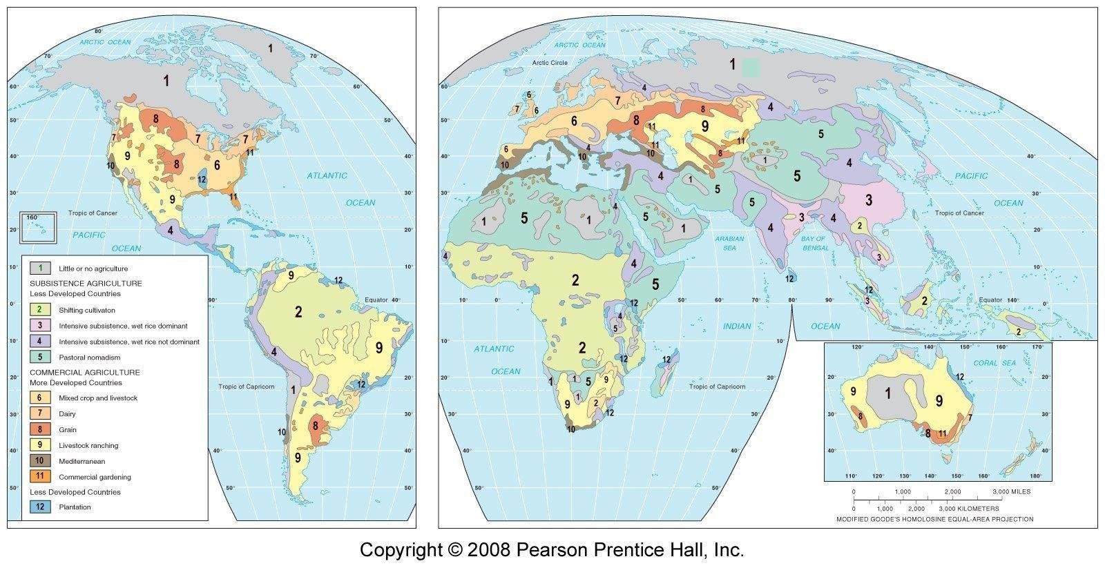
- ①2 and 5
- ②6 and 7
- ③8 and 9
- ④10 and 11
- ⑤3 and 4
5.A family in East China farms a small plot mostly by hand, using double cropping of rice. This is best classified as [3.4점]
- ①extensive subsistence, shifting cultivation
- ②extensive subsistence, pastoral nomadism
- ③intensive subsistence, wet rice dominant
- ④intensive subsistence, rice not dominant
- ⑤commercial plantation agriculture
6.Based on the graph, net income falls most steeply with distance from the market for which land use? [3.4점]
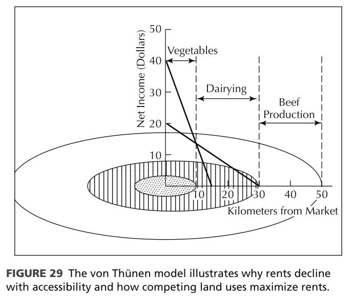
- ①Beef production
- ②Vegetable growing
- ③Dairy production
- ④Wood and fuel production
- ⑤All fall at the same rate
7.Which of the following best explains why the rigid concentric zones of the Von Thünen model are blurred today? [3.4점]
- ①Farmers now sell their crops only in nearby local markets.
- ②Land rent no longer varies with distance to a city.
- ③Soil quality and climate have become uniform around the world.
- ④Refrigerated transport and global supply chains blur them.
- ⑤Most farmers have returned to subsistence agriculture.
8.The aerial photo shows a large livestock facility set among crop fields in Iowa. Which type of agriculture is it most closely associated with? [3.5점]
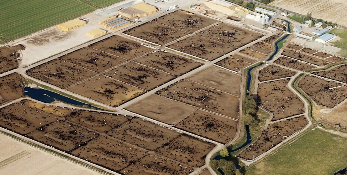
- ①Mixed crop and livestock farming
- ②Livestock ranching over extensive arid land
- ③Pastoral nomadism with seasonal migration
- ④Commercial gardening for urban markets
- ⑤Plantation agriculture based on a single cash crop
AP 인문지리 (예상) · 1 / 4
9.Kansas is highlighted on the Great Plains map. In which wheat belt is Kansas located, and when is the wheat planted there? [3.5점]
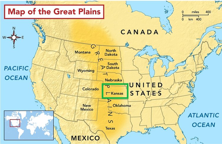
- ①Spring wheat belt; planted in spring
- ②Spring wheat belt; planted in autumn
- ③Winter wheat belt; planted in spring
- ④Dairy belt; planted in autumn
- ⑤Winter wheat belt; planted in autumn
10.Plantation agriculture is practiced in tropical and subtropical __(A)__, but is often owned or managed by transnational corporations based in __(B)__. [3.5점]
- ①(A) MDCs / (B) LDCs
- ②(A) MDCs / (B) MDCs
- ③(A) LDCs / (B) MDCs
- ④(A) LDCs / (B) LDCs
- ⑤(A) polar regions / (B) MDCs
11.Which item moved from the Old World to the New World in the Columbian Exchange? [3.5점]
- ①Tobacco
- ②Cassava
- ③Cattle
- ④Tomato
- ⑤Maize
12.All of the following describe the potato's path EXCEPT: [3.5점]
- ①It originated in the South American Andes, a mountain region
- ②It became a staple crop, especially in Ireland and Northern Europe
- ③After reaching Europe, it later diffused to the rest of the world
- ④It originated in Southwest Asia and reached the Americas later
- ⑤It came to play a vital role in global food security
13.Which Green Revolution characteristic is correctly paired with its description? [3.5점]
- ①Advanced irrigation: dams, electric pumps, and center-pivot systems for thirsty HYVs
- ②High-yield varieties: nitrogen fertilizers, pesticides, herbicides, and mechanical inputs
- ③Agrochemical expansion: tractors, combine harvesters, and seed drills
- ④Mechanization: dwarf wheat and IR8 Miracle Rice
- ⑤Agrochemical expansion: dams and center-pivot irrigation
14.In an arid region, heavy irrigation water evaporates in intense heat and mineral salts build up on farmland. Which environmental consequence is this? [3.5점]
- ①Soil salinization
- ②Water pollution by eutrophication
- ③Loss of biodiversity from monoculture
- ④Aquifer depletion
- ⑤Deforestation for fuelwood
15.Food security means access to sufficient, safe, and nutritious food __(A)__; the pillar concerning proper food processing, nutrition, and clean water is __(B)__. [3.5점]
- ①(A) at harvest time only / (B) Utilization
- ②(A) at all times / (B) Availability
- ③(A) in cities only / (B) Access
- ④(A) at harvest time only / (B) Stability
- ⑤(A) at all times / (B) Utilization
16.Which problem and example are correctly paired? [3.5점]
- ①Desertification: the Ogallala Aquifer
- ②Aquifer depletion: the Ogallala Aquifer
- ③Water conflict: the Sahel region
- ④Salinization: the Aral Sea crisis
- ⑤Aquifer depletion: the Sahel region
17.Which pairing of factor type and example is correct for rural-to-urban migration? [3.5점]
- ①Push factor: loss of agricultural jobs due to mechanization
- ②Push factor: superior healthcare and higher education facilities
- ③Pull factor: poverty and land scarcity in rural areas
- ④Pull factor: armed conflict in the countryside
- ⑤Push factor: job opportunities in manufacturing and services
AP 인문지리 (예상) · 2 / 4
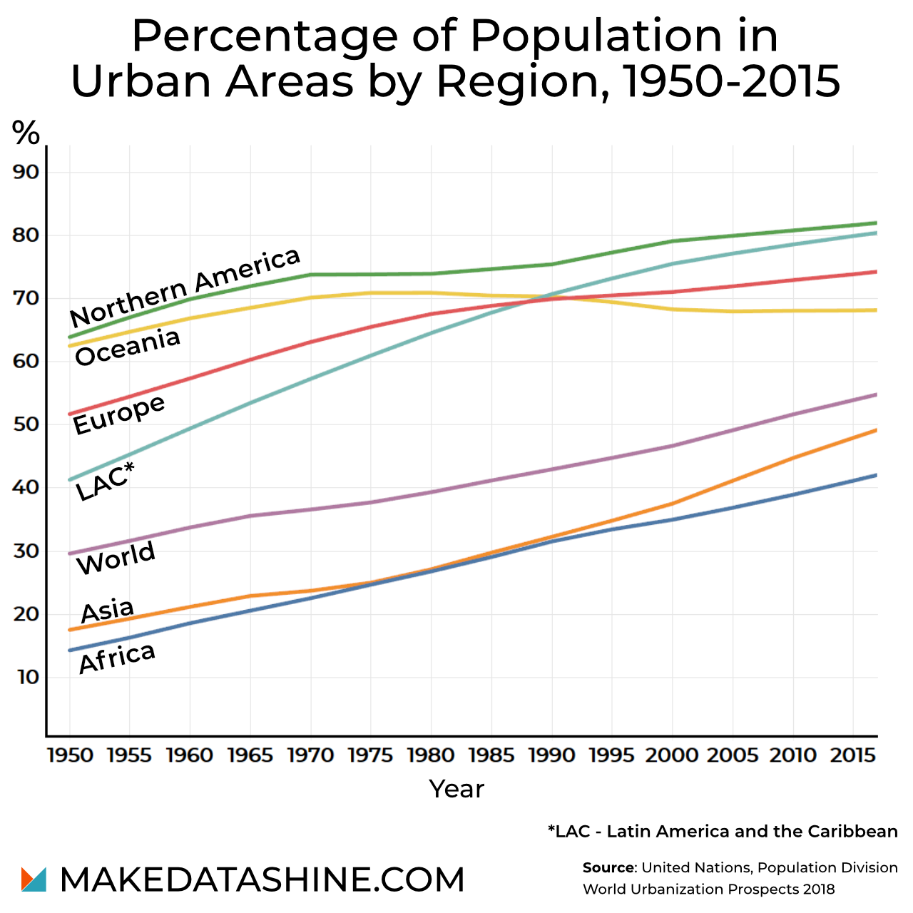
18.On the graph, which region's urban percentage shows little change in the later decades? [3.4점]
- ①Africa
- ②Latin America (LAC)
- ③Oceania
- ④Asia
- ⑤World
19.Why does urban sprawl drain municipal budgets? [3.4점]
- ①Most residents use public transit, which needs costly subsidies in low-density areas.
- ②Greenbelts require cities to buy every farm on the urban fringe each year.
- ③High-rise buildings in the city center require services for fewer people.
- ④Tax revenue always rises faster than the cost of providing new services to residents.
- ⑤Water, power, roads, and emergency services must be extended over large distances.
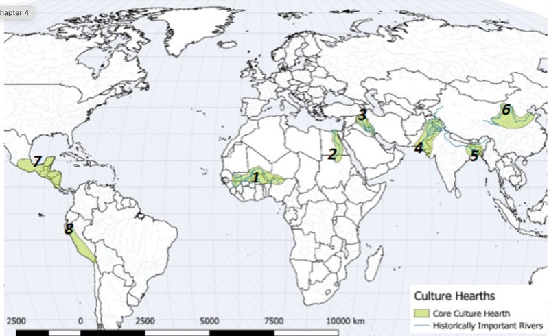
20.The river-valley hearths of urbanization shown on the map shared which set of conditions? [3.4점]
- ①Cold climates, mountain terrain, and scarce water
- ②Fertile soil, a reliable water supply, and a favorable climate
- ③Fertile soil but an unreliable water supply and harsh climate
- ④Deserts, volcanic soils, and coastal ports with no river access
- ⑤Dense forests, heavy rainfall, and no major rivers
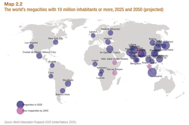
21.On Map 2.2, which city is shown as a new megacity expected by 2050 rather than a megacity in 2025? [3.5점]
- ①Lagos
- ②Al-Qahirah (Cairo)
- ③São Paulo
- ④Dar es Salaam
- ⑤Kinshasa
22.Metacities result from continuous urban growth leading to vast __(A)__ and megalopolises, and managing them requires __(B)__ coordination that local municipal governments often lack. [3.5점]
- ①(A) squatter settlements / (B) cross-jurisdictional
- ②(A) conurbations / (B) single-neighborhood
- ③(A) conurbations / (B) cross-jurisdictional
- ④(A) greenbelts / (B) single-neighborhood
- ⑤(A) rural villages / (B) household-level
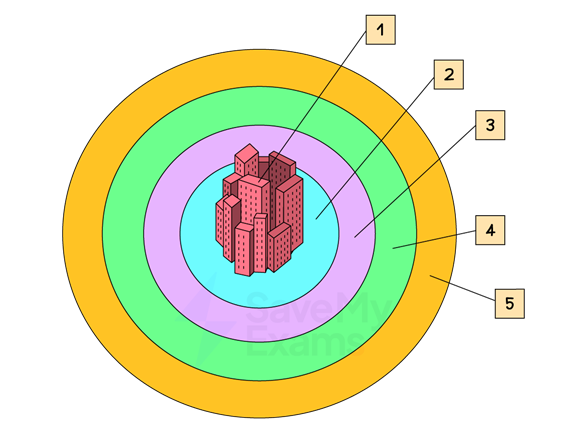
23.In the numbered diagram, the zone labeled 3 is best described as which of the following? [3.5점]
- ①The commercial center of the city
- ②The richest part of the urban agglomeration
- ③Where most working-class CBD employees live
- ④Newer buildings with better amenities
- ⑤A slum area with tenements
24.Which statement is supported by the bid-rent graph with Retail, Manufacturing and Residential lines? [3.5점]
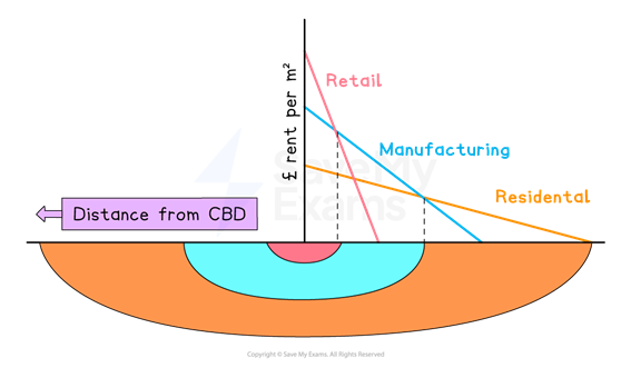
- ①Retail bids the highest rent near the CBD
- ②Residential has the steepest line
- ③Manufacturing bids highest at the CBD
- ④Retail forms the outermost band
- ⑤Rent rises as distance from the CBD grows
25.Which statement correctly contrasts the CBD with the Commuter's zone? [3.5점]
- ①The CBD has many skyscrapers; the Commuter's zone has no buildings at all
- ②The CBD is the poorest; the Commuter's zone is the most valuable
- ③The CBD relies on cars; the Commuter's zone on subways
- ④The CBD has high daytime population; the Commuter's zone has spacious housing
- ⑤Both have low land values and few jobs
26.Which of the following is NOT given on the slides as a limitation of the Concentric Zone Model? [3.5점]
- ①It lacks applicability outside North America
- ②It was drawn from Tokyo rather than a North American city
- ③It does not account for geographical limits
- ④It does not account for gentrification
- ⑤It assumes an isotropic plane without barriers
AP 인문지리 (예상) · 3 / 4
※ 서술형 — 완전한 영어 문장으로 답안란에 서술하시오.
서술형 1 [4점] — 4점 (원 4점 × 1)
The Concentric Zone (Burgess) model is a model of urban land use.
(a) Identify the person associated with the Concentric Zone model, the year it was proposed, and the type of city it depicts. (1 point)
(b) Describe ONE characteristic of the Central Business District (CBD) in the model. (1 point)
(c) Explain how invasion and succession operate in the Zone in Transition. (1 point)
(d) Explain ONE criticism of the Concentric Zone model. (1 point)
(a) Identify the person associated with the Concentric Zone model, the year it was proposed, and the type of city it depicts. (1 point)
(b) Describe ONE characteristic of the Central Business District (CBD) in the model. (1 point)
(c) Explain how invasion and succession operate in the Zone in Transition. (1 point)
(d) Explain ONE criticism of the Concentric Zone model. (1 point)
| 문항 | Task | 배점 |
|---|---|---|
| (a) | Identify the person, the year, and the type of city the model depicts. | 1점 |
| (b) | Describe ONE characteristic of the CBD. | 1점 |
| (c) | Explain how invasion and succession operate in the Zone in Transition. | 1점 |
| (d) | Explain ONE criticism of the Concentric Zone model. | 1점 |
서술형 2 [3점] — 3점 (원 4점 × 0.75)
Answer the following questions about suburbanization and urban sprawl.
(a) Define urban sprawl. (1 point)
(b) Identify TWO causes of suburbanization in the United States. (1 point)
(c) Explain ONE negative impact of urban sprawl. (1 point)
(d) Describe ONE consequence of suburbanization for the city center. (1 point)
(a) Define urban sprawl. (1 point)
(b) Identify TWO causes of suburbanization in the United States. (1 point)
(c) Explain ONE negative impact of urban sprawl. (1 point)
(d) Describe ONE consequence of suburbanization for the city center. (1 point)
| 문항 | Task | 배점 |
|---|---|---|
| (a) | Define urban sprawl. | 0.75점 |
| (b) | Identify TWO causes of suburbanization in the United States. | 0.75점 |
| (c) | Explain ONE negative impact of urban sprawl. | 0.75점 |
| (d) | Describe ONE consequence of suburbanization for the city center. | 0.75점 |
서술형 3 [3점] — 3점 (원 6점 × 0.5)
The Green Revolution was a period of rapid technological, agricultural, and scientific innovation that transformed global food production in the mid-to-late twentieth century. However, its impact was geographically uneven.
A. Identify TWO specific technological innovations associated with the Green Revolution. (1 point)
B. Explain ONE major success of the Green Revolution in boosting global food security. (1 point)
C. Explain TWO reasons why the Green Revolution had a limited impact in Sub-Saharan Africa. (2 points)
D. Explain ONE negative environmental consequence resulting from the practices of the Green Revolution. (1 point)
E. Describe ONE economic barrier faced by small-scale farmers in Developing Countries (LDCs) when adopting Green Revolution technologies. (1 point)
A. Identify TWO specific technological innovations associated with the Green Revolution. (1 point)
B. Explain ONE major success of the Green Revolution in boosting global food security. (1 point)
C. Explain TWO reasons why the Green Revolution had a limited impact in Sub-Saharan Africa. (2 points)
D. Explain ONE negative environmental consequence resulting from the practices of the Green Revolution. (1 point)
E. Describe ONE economic barrier faced by small-scale farmers in Developing Countries (LDCs) when adopting Green Revolution technologies. (1 point)
| 문항 | Task | 배점 |
|---|---|---|
| A | Identify TWO specific technological innovations associated with the Green Revolution. | 0.5점 |
| B | Explain ONE major success of the Green Revolution in boosting global food security. | 0.5점 |
| C | Explain TWO reasons why the Green Revolution had a limited impact in Sub-Saharan Africa. | 1점 |
| D | Explain ONE negative environmental consequence resulting from the practices of the Green Revolution. | 0.5점 |
| E | Describe ONE economic barrier faced by small-scale farmers in Developing Countries (LDCs) when adopting Green Revolution technologies. | 0.5점 |
- 끝 -
AP 인문지리 (예상) · 4 / 4